I saw this truck when I stopped for a red light.

I couldn’t tell what kind of rescues Super Dave performs, so I looked him up online. He’s a handyman. The attitude displayed on his truck makes me want to call him when I need something handy done.
I saw this truck when I stopped for a red light.
I couldn’t tell what kind of rescues Super Dave performs, so I looked him up online. He’s a handyman. The attitude displayed on his truck makes me want to call him when I need something handy done.
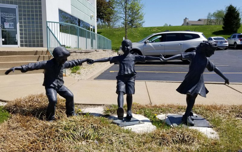
I saw this playful sculpture in front of an orthodontist’s office.
When Ted and I ordered a replacement bay window for our kitchen last August, I decided new windows deserved new valances. Those currently on the windows might be twenty years old. (Time flies. Who’s counting?) At the time, I didn’t realize it would take six months to get the windows.
When Ted and I excitedly (?) re-hung the blinds–which are only three years old, not twenty–on the new windows in February, we discovered that they didn’t look very nice. To allow for the window-opening cranks on the old windows, the two outer blinds were made shorter than the center one. The new windows have recessed cranks, so the two shorter blinds looked like mistakes on the new windows.
I talked to the decorator about this and she suggested sending the blinds to the manufacturer to have the cords made two inches longer. (Because of the style of my blinds and the mechanism that operates them, re-stringing the cords is not a simple thing.) There was enough fabric in the length of the blinds to accommodate the extra two inches, so the adjustment was covered by my lifetime warranty. Great!
I stalled again on making the valances, deciding to wait until I had blinds on all three windows. In today’s market, however, instant gratification is becoming harder to find. It took eight weeks to get my adjusted blinds back. On the bright side, we now have three equally long blinds on these windows.
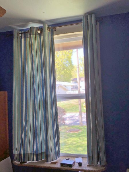
Eight months after deciding to replace the kitchen valances, with the windows replaced and the blinds adjusted, I headed for my sewing machine. It was a quick project. These are the old valances . . .

. . . and these are the new ones. There’s not a striking difference, but the lighter color is a nice change.

We had a new pool liner installed a few weeks ago and we thought we were ready to swim. Then, one day while Ted and I were working in the pool area, we noticed that the pool surface had a lot of leaves on it. They should have been sent to the skimmer, but we discovered that hadn’t happened because the pump wasn’t running. I couldn’t get it started, so I called the pool company. The service manager (Jim) told me “That doesn’t make sense. I’ll come out and look at it.” He tried everything in his bag of tricks, but nothing started the pump. He told us he’d be back the next day with a new pump.
Jim and his daughter came back the following day and replaced the old pump in about 30 minutes. Now that we have a new liner and a new pump, we should be good for at least ten years.
The arrow points to the old pump. The new one is in the box on the right.

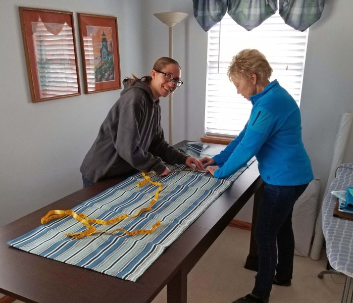
For several years, Kari has has been telling me she wants to learn to sew. A few years ago, I gave her a Christmas gift coupon for free sewing lessons, and she finally cashed it in. She decided to make draperies for Teddy’s bedroom. Her theory for choosing that project was that draperies would be pretty easy because they’re all straight seams.
Kari and I shopped together for fabric. We talked about different styles of draperies she could make and then we did some browsing. She took pictures of fabrics she thought Teddy would like, then went back to the store a few days later to purchase her final selections.
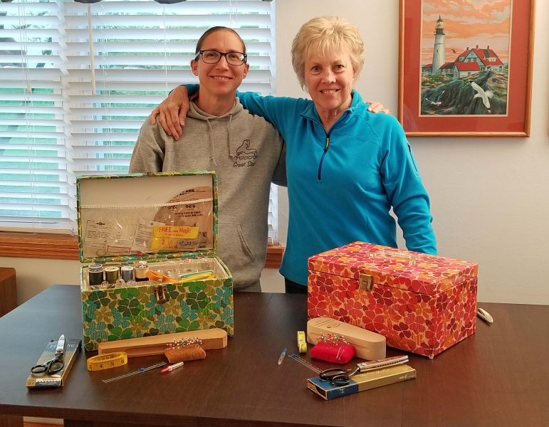
We decided to work at my house because I have a project room where we could simply leave things in progress. Kari measured Teddy’s window, then brought her fabric and her sewing box to my house. Before we went to work, we took some time to compare our sewing boxes. We have matching boxes because my mother bought one for herself and one for me when I was in college, and Kari has my mother’s box, including its contents. We shared memories of my mom / Kari’s grandma while we looked through the sewing boxes. Some of the items in our boxes match because my mom provided me with the same items she had.
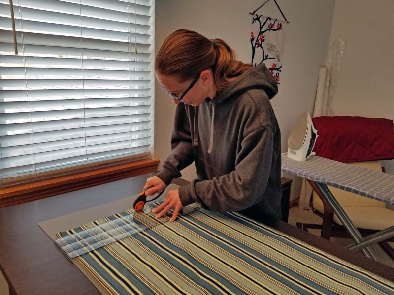
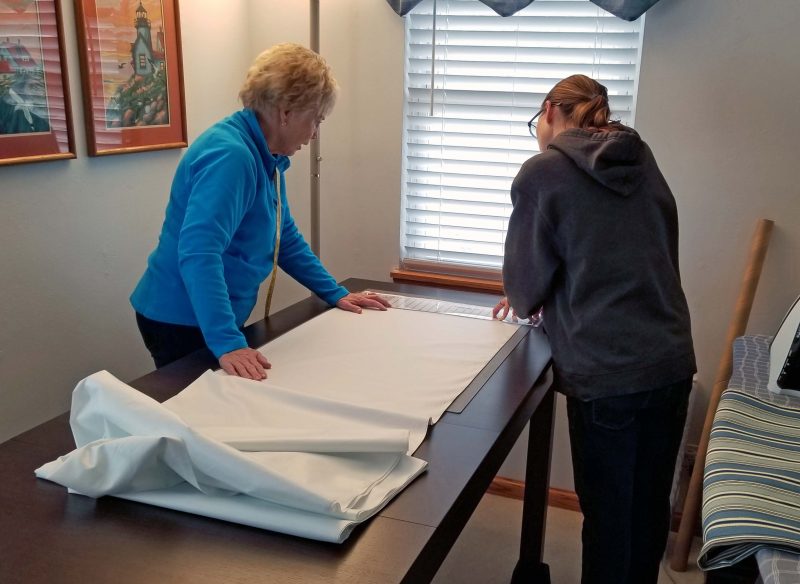
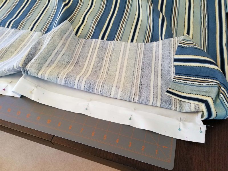
The first day of a sewing project is kind of dull because it’s all prep work: figuring, measuring, squaring the fabric, marking, cutting, etc. At the end of the session, you have nothing to show for those hours except a pile of cut fabric. We started by measuring and cutting the fabric. I had some leftover lining that I convinced Kari to use for Teddy’s drapes, so we measured and cut the lining too.
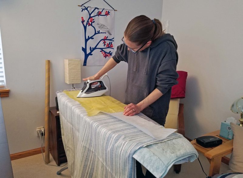
Because Kari decided to hang the panels from grommets, I suggested a heavyweight interfacing at the top to keep the fabric in the header from becoming floppy. Kari got a lesson on how to use a pressing cloth to apply iron-on interfacing.
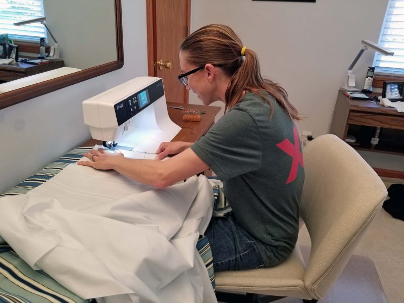
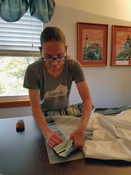
The spool pin on Kari’s sewing machine is broken and the replacement she ordered hasn’t arrived, so we used my sewing machine. Here’s a picture of Kari attaching the lining to the fabric. After sewing the fabric and the lining together, Kari told me I was right about the lining. (I knew she’d like it.)
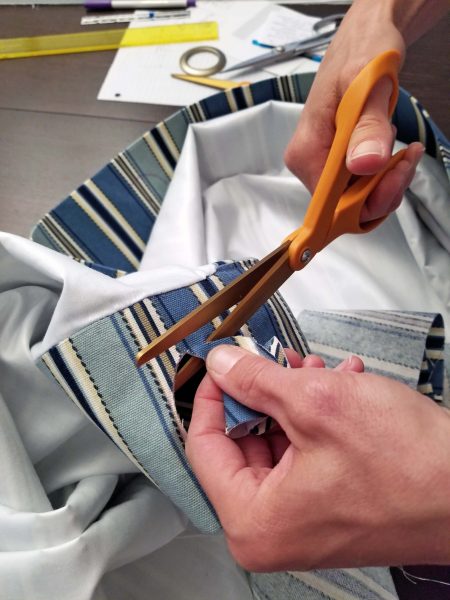
Neither of us had ever used grommets, but we discovered that they’re pretty easy to install: mark, cut, and snap together. Kari did a perfect job of grommet installation.
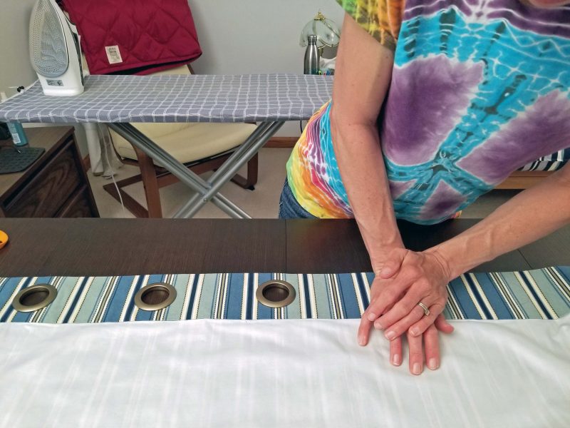
Then it was time to hem the first panel. Using Kari’s window measurements, we pinned the hem in place and she took the panel home and hung it from her new rod to check the length. All that time we spent measuring paid off: it was perfect. When she brought the panel back to my house, we marked and sewed the lining and the drapery hems.
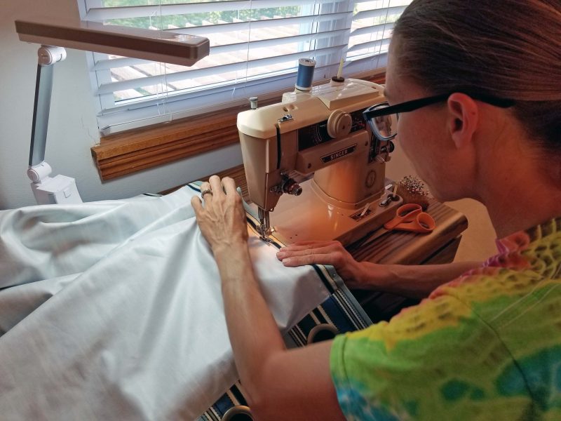
It took four sewing sessions to finish both panels. After the first session, Kari said she would enjoy using my “heritage” sewing machine. (That would be my now-58-year-old sewing machine, which I haven’t had the heart to get rid of. I bought it in college and it has sentimental value to me.) I set up my vintage machine for Kari and she used it for the remaining sewing sessions. In the photo below, she’s finishing the topstitching on the side hems of the second panel.
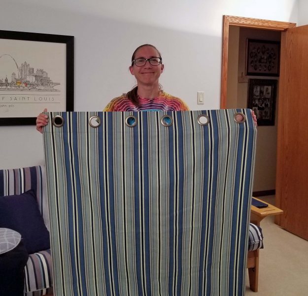
Kari said she wanted a picture of both of us with her finished draperies, so we called Ted to play cameraman. Here we are showing off Kari’s successful first sewing project.
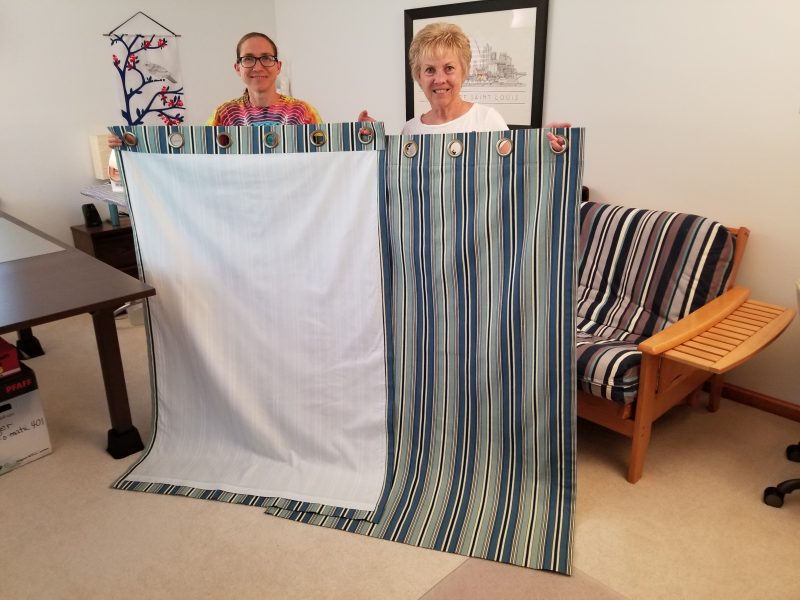
And voilá! Teddy has new draperies in his bedroom. Don’t they look nice?
Kari told me this project has inspired her. Now she wants to make a cover for her sewing machine, draperies for other windows in her house, and Christmas gift bags. She was disappointed when I told her we’ll have to wait for late summer or early fall for the Christmas fabrics to be available in the stores. I’m looking forward to sewing together again. It reminds me of my mom teaching me to sew. Pass it on, right?
Three years ago, we planted an arborvitae hedge. The trees on each end are doing very well, but the trees in the middle don’t want to grow. One tree died in the first year and was replaced under the warranty, but now we have four trees in the center area that are failing. The difference in size between the trees on the ends and those in the middle is obvious. You can’t see between the end trees, but there’s lots of space between the stubby center ones–just where we want the privacy. The trees were all planted at the same time except for the totally brown one, which was replaced after the first year. The replacement lasted about 18 months. That spot in the ground has now killed two trees in three years. When we ordered this round of replacements, the landscaper suggested having the crew overdig the holes and put in new soil.

The landscaper’s suggestion made us think a soil test might be a good idea. I thought we’d have to go through the county extension service, or at least a nursery, to get an expert to perform a soil test. I shouldn’t have been surprised, but when I searched online for someone to do a soil test, I discovered that soil test kits are available at–where else?–Wal-Mart.
This is the stuff included in the testing kit. As I set out the instructions, the soil samples, the test tubes, the chemistry tablets, the distilled water, and the color chart, I felt like Bill Nye the Science Guy. All I needed was safety goggles. It brought back memories of high school chemistry class when we did experiments on Fridays.
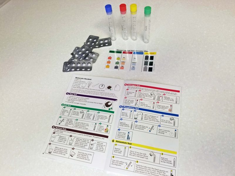
Soil testing isn’t hard, but it’s definitely time-consuming. It took me about four hours to test six soil samples. The results showed that our troubled center section of arborvitae trees could use some pH and a lot of nitrogen, and our magnolia trees could also benefit from some nitrogen. Ted bought some nitrogen and treated the magnolia trees. The landscaper’s plan to add new soil might solve the arborvitae problem, but I guess we’ll have to test the new soil to find out.
I saw this picture of Dr. Anthony Fauci (Tony to those who know him) and noticed that he has an appropriately clever face mask, covered with test tubes, beakers, Bunsen burners, etc.

Check out today’s seven-day forecast for our area.
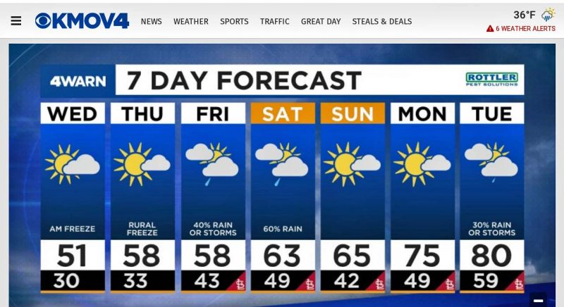
The record low for tonight (Tuesday) is 32 degrees, set in 1904. We’re probably going to break that record with a low in the mid- to upper 20s. We spent today in the 30s and, just for fun, we had a late season snowfall.


The ground is above freezing, so the snow will disappear quickly. The temperatures will stay cold for another day and night, probably dropping below freezing again tomorrow night. The normal high and low temperatures for today are 68 and 48, so this cold weather is definitely unusual.
Did you notice that the high for next Tuesday is expected to be around 80 degrees? It’s quite a ride, going from a record low in the 20s to a warm 80 degrees six days later.
Spring: the least predictable season.
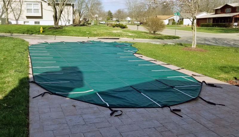
Last week, we needed to get our pool ready for the scheduled installation of a new liner. The first step was to remove the winter pool cover. Ted estimates the cover weighs about 80 pounds, not counting the water it picks up as we drag it over the pool to remove it. I think his estimate might be low. I had already washed the driveway so we could spread the cover out to hose it off before we pack it away until late fall. Our neighbor, Will, saw us washing the pool cover and said, “Oh, no! If you guys are opening your pool, it’s going to snow next week!” Hahaha.
While the cover lay drying in the sun, we started draining the pool. With the pump pulling the water out through a two-inch hose, that took about 5 hours. While waiting for the pool to drain, I power washed the winter dirt from the pool deck and the patio, and hosed off the sidewalks and the front porch. Ted brought out a few more pieces of lawn furniture for the nicer weather, then mowed the lawn.
With a new liner coming, we wanted the pool steps and the upper edge around the pool to be sparkling white. It’s much easier to clean the edge by standing in the pool than to kneel on the pool deck, leaning over the water to scrub it. Since the pool was empty, Ted got to work.
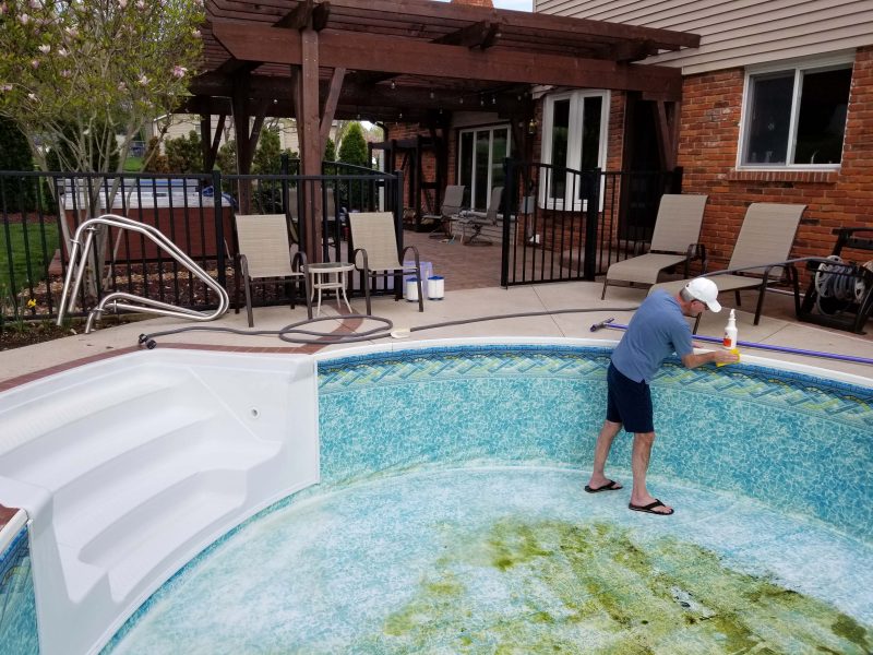
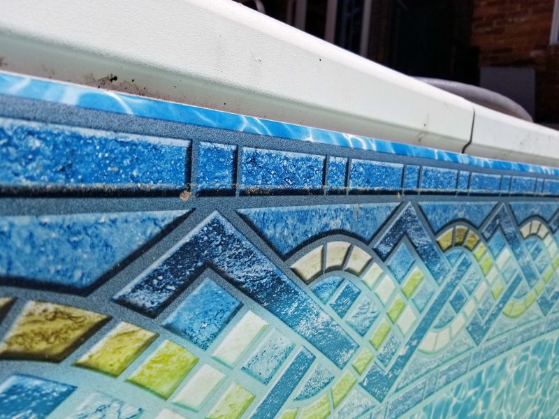
If you’re a long-term reader, you might be thinking, “Didn’t they just put in a new liner a few years ago?” You’re right; liners should last at least 10 years. Look at the top edge of the liner in the photo above. It looks like there’s a dark border, but that’s not a border; that’s how much the liner faded in 3 years. When the pool guy saw that, he said it should have lasted much longer (say, 10 years), so he activated the warranty to save us a chunk of money on the new liner and on the installation labor. A closer look at the liner in the photo below clearly shows the fading. It also shows why Ted is scrubbing dirt off the top white edge.
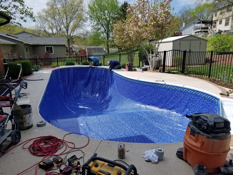
The pool crew arrived bright and early the next morning. They cut around the bottom edge of the liner and removed the bottom piece, then released the sides, and carted it all away. There was some clean-up to be done before dropping the new liner. Hard objects and / or deep depressions under the vinyl liner can result in puncture holes, so a complete and detailed vacuuming and some touch-up fill work were needed.

Two hours after the crew arrived, they had the new liner dropped and they were making some final adjustments before working out all the wrinkles and installing the jets, the light, and the drain covers.
The guys started filling the pool before they left and told us to turn off the water when it reached the bottom step. The next morning, they came back to adjust any remaining stubborn wrinkles that had been pushed ahead of the water. After that, we were “go” to fill it all the way. With two hoses running, it took 16 hours to fill the pool to the top. One of the pool crew guys came back the next day to install the ladder and the railings, to turn on the pump, and to check the equipment to make sure everything was running well. We are now ready for the 2021 swim season.

Having a new hot tub means having one more thing to clean up in the spring and in the fall. We’ve been enjoying the hot tub for almost six months, so it’s time to freshen it up. That job turned out to be a lot more time-consuming than we’d expected.
The obvious first step was to drain the hot tub. It sounds easy and there really isn’t anything to do except connect a garden hose to the hot tub drain. BUT, first you have to bring the water temperature down from that lovely, relaxing 104 degrees. The owner’s manual suggested 24 hours, but the overnight temperature dropped to the low 40s, so cooling the water wasn’t a problem–we just took the cover off and let the night air do its thing. The water was more than cool enough by morning, so while the pool was draining, we connected a garden hose to drain the hot tub. Draining it took a surprising 5 hours–the same amount of time it took to empty the pool, which has about 34 times more water than the hot tub. We did not see that coming! Talk about a setback in your schedule! The pool’s two big drains, its pump, and its two-inch drainage hose work a lot faster than a 5/8″ garden hose counting on gravity to do the work.
When the hot tub was (finally) drained, I started cleaning it while Ted cleaned up the pool. It sounds amazing when the literature and the salesman tell you that your hot tub has 6 gazillion jets. “Ooh, aah,” you say. “Is that the most we can get?” It’s a different story when you have to remove every jet to clean it. My sore fingertips felt like I unscrewed and pulled out about 6 gazillion jets, but I reasoned there probably weren’t more than 120. Hah! When I finished, I counted them and came up with only 62 jets–half of what my fingers “reasonably” felt like I had removed.
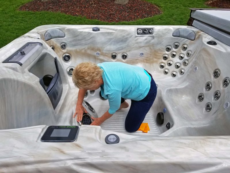
The jets had to be soaked in a vinegar/water mixture for 3 hours to remove any built-up residue in them. The two extra large jets that provide an awesome foot massage didn’t fit well in our pail and dishpan with the other jets, so we put them in the pail after the first load of jets was finished soaking. As a result, the total soak time was 6 hours. We opted for the extended time because we’d already used 1.5 gallons of vinegar and we didn’t feel like making another trip to the grocery store for more vinegar to do only two more jets.
While the jets soaked, I scrubbed. The pool store sold us some awesome non-sudsing cleaner for the tub surface. I just sprayed it on and wiped it off, and it left the surface as smooth and clean as if it had never been used. No hard scrubbing needed. I bet it would work great for cleaning the bathroom.
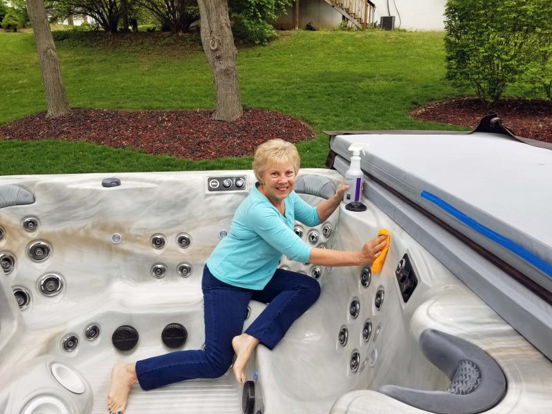
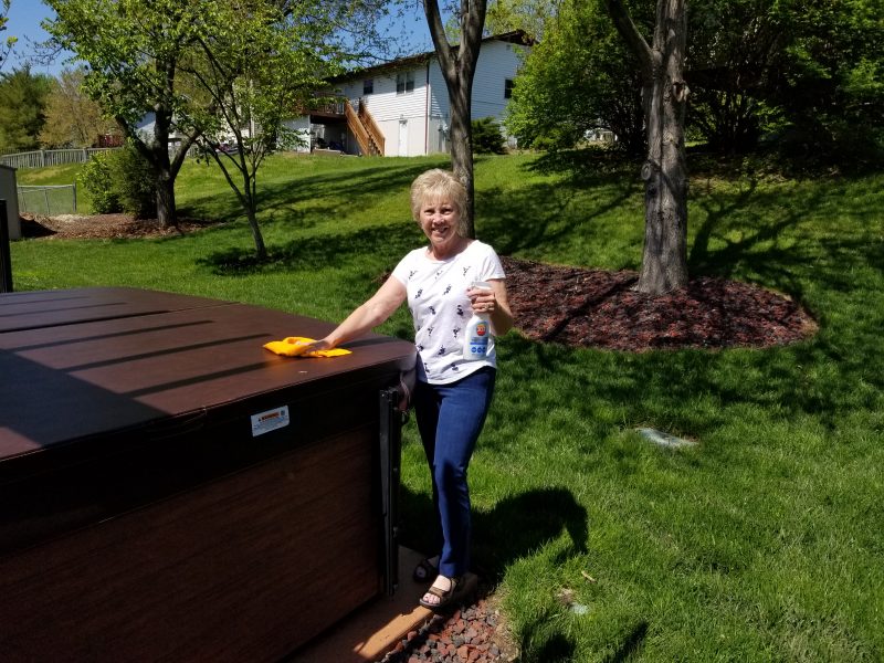
After removing and washing the headrests, I moved on to the exterior of the hot tub and wiped down the sides to get rid of the winter grit. The final cleaning task was to wash the cover and apply a coat of protectant to help prevent premature fading and weathering. That was pretty simple too–just time-consuming. Aren’t you impressed that Ted’s pictures show me smiling while I work? I feel like a TV ad. The truth is, the job wasn’t awful, but I’m good with only needing to do all of this twice a year, and we both feel that way about the pool too.
At last, I could put the garden hose inside the hot tub to fill it. It filled in about 45 minutes, but it wasn’t warm enough by evening to relax our sore muscles from all the work of cleaning the pool and the hot tub.
After spending two days getting our waterworks cleaned up for the summer season, there’s a change in the weather forecast. After a high temperature of 75 degrees today, tomorrow’s forecast includes falling temperatures, rain possibly mixed with up to one inch of snow, and an overnight low in the mid-20s. More of the same is predicted for the following day and night, except the temperatures might be a few degrees warmer. Will was right. It’s been a week since we opened the pool and we’ll probably see some snow tomorrow.
It’s time for the Dr. D Spring Award. One of the reasons I love spring in Missouri is because we have so many blooming trees. There’s beauty wherever you drive in the spring. This year, I had more than the usual number of contestants because not many trees were affected by the late frost.
I don’t know what kind of tree this is, but there are a lot of them in the area and they have very thick white flowers. You can see a redbud peeking over the white tree.

Here’s a flowering crabapple tree.

The white dogwoods are always pretty, especially when they are sprinkled throughout a wooded area.

Pink dogwoods are gorgeous. I’m not crazy about the setting, but this is a beautiful pink dogwood.
This is another flowering crabapple tree. The color is so vivid!
The judge’s (my) decision was really tough this year. I finally decided to include a new category and named this stunning star magnolia the first runner-up in this year’s spring show.

For the first time, the winner is a group of trees. It was a tough decision, but the color and scope these redbuds display to passers-by (and my love of redbuds) gave this group the edge to be named this year’s best display. Presenting . . . the Dr. D Spring Award.

I was searching for something on the internet and, to my surprise, I came across an image of an Arvin 7 transistor radio. That brought back so many memories!
Transistor radios were first mass produced in the late 1950s and were the most popular electronic communication devices of the 1960s and 1970s. (What else was there at that time? I’m drawing a blank.) Transistor radios were popular because they were pocket- or purse-size and portable (battery operated), allowing us to listen to music wherever we went.
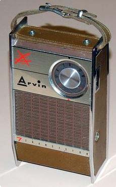
I was a pre-teen at that time and, of course, my friends and I all wanted transistor radios. I saved my allowance money and, in October 1958, I went shopping. My mom came along because I needed a driver. My choice was the Arvin 7. This was an upscale transistor radio. It was named the Arvin 7 to indicate that it had seven transistors. Wow! I think it cost about $30 when the cheaper models cost around $10-$15. It was so cool! It looked like this and was about 4″ x 6″.
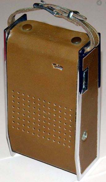
It came with a leather cover for the front. You can see the earphone jack on the side. That was a nice feature.
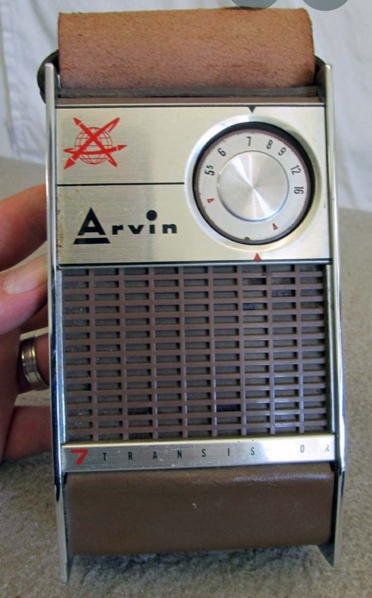
The cover had one snap on the bottom and two on the top and could be attached over the back as well. Really cool!
These radios offered only AM frequencies, but that was fine because my friends and I all listened to the same AM station that every teenager in the Milwaukee frequency area listened to: current pop music on “WOKY in Milwaukee–920 on your radio dial.” My parents (and my friends’ parents) hated WOKY (pronounced “walk-y”). In fact, my mom once told me that the same song sounded better on any other station. Yeah, right. If Bing Crosby sang it instead of Elvis!
One of the really neat things you used to be able to do with AM radio was pick up far-away clear-channel stations on especially clear nights. With my awesome little transistor radio, I occasionally heard Wolfman Jack in New York and I remember picking up New Orleans and Chicago too. Those were the days.
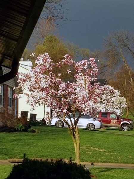
March: In like a lion, out like a lamb, right? Well, early March was cold. (Lion?) Then the weather started warming up in mid-March, and late March was beautiful. (Lamb.) In fact, we had so many warm days in the 60s, 70s, and even a few 80s, that spring flowers, shrubs, and trees burst into bloom. Our magnolia tree is as eager for spring each year as I am. As a result, it usually loses its blooms to a late frost. This year, it reached full bloom and held it for several days. I dared to hope that spring was really, truly here.
Here’s my favorite tree–the magnolia that loves to bloom ASAP every spring.

When we had our maple tree cut down, we also had the tree-cutting crew shape a smaller magnolia to grow more evenly out of the shadow of the maple tree. The tree-cutter said the little magnolia wouldn’t bloom this spring, but it will by next year. No, sir! These trees can’t wait to bloom! Here’s the little tree, blooming like crazy in spite of last summer’s pruning.

Our cherry tree in the back yard gets noticeably taller and blooms more fully each year.

The daffodils around the pool are in full bloom. I love them!

And then, . . . And then, . . . And then, . . . Hah! April Fool! In the early morning hours of April 1, our temperature dropped to 26 degrees. As if that wasn’t bad enough, in the early morning hours of April 2, it dropped to 25 degrees! And that was the end of the beautiful magnolia blossoms.


The cherry tree blossoms, the daffodils, and the not-yet blooming different variety of magnolia trees in the back yard all look fine. I think it might be that our back yard is more protected with houses and a hill behind us and didn’t get hit as hard by the frost. The two magnolia trees in the front yard are more exposed because of the wide street and the open space between houses across the street.
The temperature got back into the mid-70s today and is forecast to stay in the 70s and maybe even low 80s the rest of this week. We had spring, then a hard hit of frost, and we’re right back to spring. The Midwest is a great place for variety in the weather in March and April. I could do without the mid-spring frost, but I love all the things that bloom, making spring my favorite season every year.
Author’s note: Ted and I are optimists. We’re scheduled to open our pool in nine days.
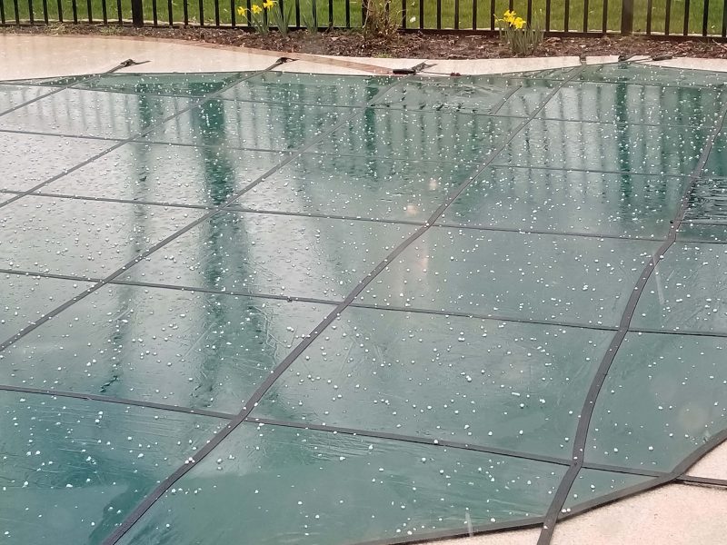
It’s spring in the Midwest, so severe thunderstorm and tornado watches and warnings are not unusual. We had a severe thunderstorm warning and a tornado watch a few days ago. Our area experienced thunderstorms; the tornado hit east of us, just across the Mississippi River.
There was a wicked-looking dark sky.
And then the wind and hail hit. We only had pea-sized hail, but just a few miles away, two-inch hail was reported. The temperature dropped from 83 degrees to 67 degrees in 12 minutes!
Today, more storm watches were issued by the NWS. We only had rain with a little thunder, but tornadoes were reported about 15 miles north of us. They were small tornadoes resulting in nothing worse than property damage and fallen tree limbs.
You have to keep tuned to the weather in the spring if you live in the Midwest.
As Ted and I were taking our walk one day, we noticed fossil imprints in the concrete. We identified them as leaf imprints from ancient oak and maple trees.


Ted and I estimated these fossil imprints to be at least 15-20 years old, dating back to the last time the street was repaired with new concrete.
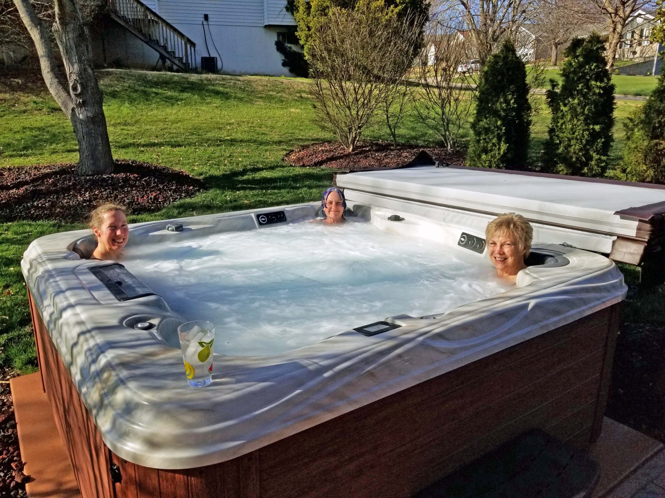
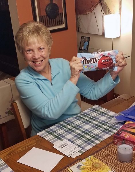
My birthday “season” usually lasts 6-8 weeks, meeting several friends for lunches and spending time with family members. Thanks to COVID, my 2021 birthday season was much shorter. The first two days of the season were spent with family. Kathy and Annette came for a visit and Kari’s family joined us for part of that time.
While Kari and Sky were at work, Kathy, Annette, and I made use of the hot tub. In the evening, Kari and Teddy joined us to relax in the hot tub again. Annette enjoyed it so much, she didn’t want to get out. Ted thought we might have to prop her up so she wouldn’t drown while she slept in it overnight.
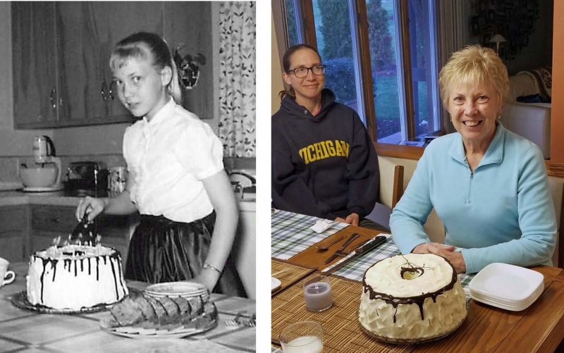
As usual, I made Vienna Torte for my birthday. This dessert is a long-term annual tradition for me, dating back to my childhood. The chocolate drizzle on the cake looks pretty blah this year. It cooled too much before I poured it, so it set almost as soon as it hit the cake. It wasn’t as pretty, but it was a thicker piece of chocolate with each serving of cake.
There were gifts, including my favorite m&ms: Easter pastels.
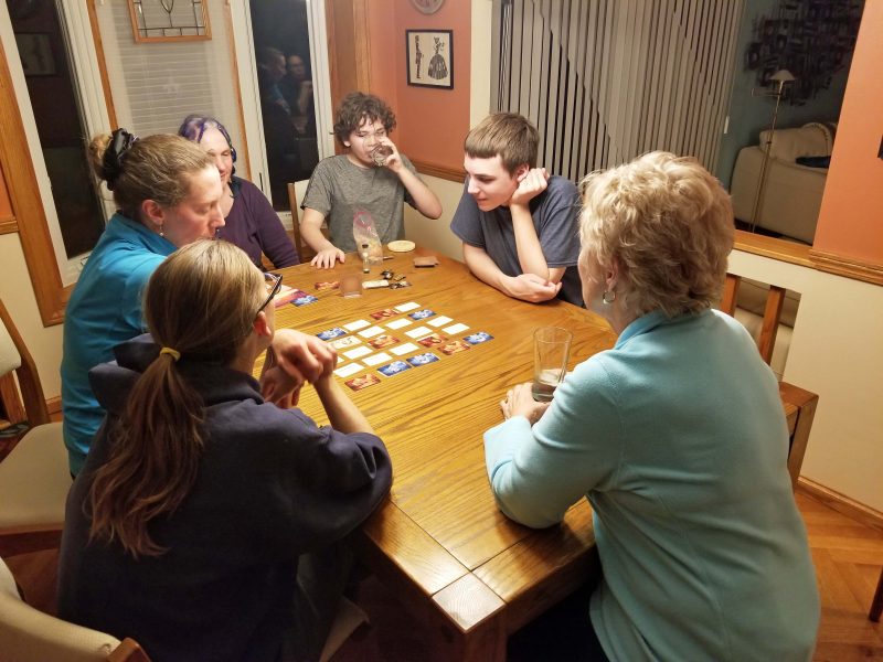
Another great gift was Codenames. It’s the perfect game for a family group. It was easy to learn, a little bit challenging, fun to play, and didn’t require too much deep thought to prevent us from having fun with each other while we played.
The day after Kathy and Annette’s visit, I had a birthday lunch with one of my friends. The weather was beautiful, so we went to a restaurant that has an outdoor patio overlooking a pond in a pretty landscaped setting. The food was good and the company was great. That birthday lunch was followed by a birthday video call with Jeff and La in the evening and another video call with Thom, Katie, and Sefton two days later.
And that was it: five days of celebrating my birthday this year. I always enjoy my birthday, and this was no exception. It’s the quality of the time spent celebrating, not the quantity of it, and I definitely had quality time with my family and my best friend. Until next year, . . . .
Ted and I are great-grandparents! Our first great-grandchild was born last week. His name is Oliver Quentin and he is the oldest son3–the oldest son of the oldest son (Alex) of our oldest son (Jeff). We’re definitely going to add Ted to the group and take a four-generation photo of the men when we meet Oliver. Ted and I are excited about the new addition to our family and we are looking forward to visiting Alex, Kaitlyn, and Oliver later this year. I’ve decided to be GG (Great Grandma) to our great-grandchildren; Ted wants to be GP (Great grandPa).

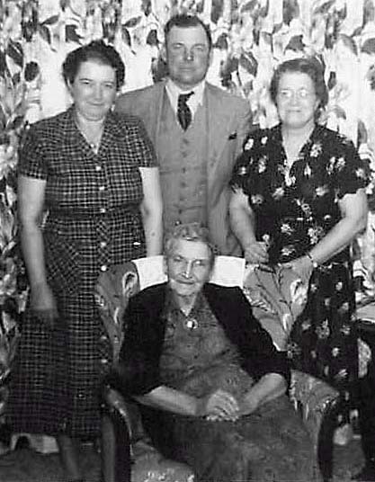
Meanwhile, I need a mental great-grandma image adjustment. Here’s my great-grandma (seated) with her three children. The lady on the right is my grandma. I was three years old when this picture was taken. To be fair, my great-grandma is eleven years older in this picture than I am now.
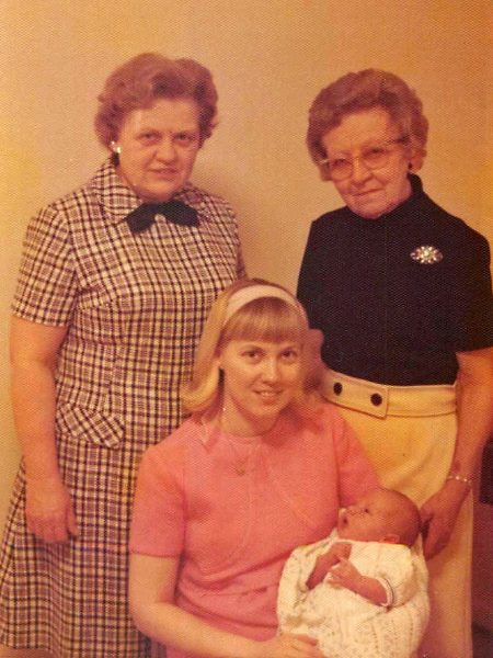
Here’s a four-generation picture of baby Jeff with his mom (me), his grandma (my mom) and his great-grandma (my grandma). Jeff was Grandma’s first great-grandchild and she is the same age in this picture as I am now.
Here’s Oliver’s great-grandma. I think there’s a bit of a contrast between those other two great-grandmas and me.

Great-grandmas aren’t what they used to be, but great-grandbabies are still just as cute as ever.

When I saw this cartoon, my passion for improving reading comprehension skills kicked in. When we read, we recognize an arrangement of symbols as words; when we comprehend, we create meaning from those recognized words. There’s a big difference between these two skills. Have you ever heard someone say, “It doesn’t matter how many times I read it; I just don’t get it”? That’s clear evidence of a lack of reading comprehension skills.
There are many studies of children’s academic skills through twelfth grade. The most well-known of these is the NAEP (National Assessment of Educational Progress), the largest nationally representative and continuing assessment of what America’s students know and can do in various subject areas. The NAEP began in 1969 and is published every four years. It assesses students’ academic skills in 4th, 8th and 12th grade. Among developed countries in the world, the United States spends, by far, the most money on education overall and the second-most per student: $810 billion overall and about $12,800 per student in public education. In spite of that, the U.S. 2019 NAEP scores in reading, math, and science are disappointing.

Given those results, is it any wonder adults have reading comprehension difficulties? There are very few studies of the academic competencies of adults. The biggest reason for this is that children can be tracked and followed fairly easily through the school system for a number of years. Adults, on the other hand, relocate and change jobs, making them harder to find for follow-up studies.
The first national comprehensive study of adult literacy was the 1992 National Adult Literacy Survey (NALS). The 2003 National Assessment of Adult Literacy (NAAL) was the first time a follow-up adult literacy study was done. The results were not good for either study. In fact, the results of the follow-up NAAL showed a decline in adult literacy when compared to the earlier NALS. Both surveys indicated that the “golden age” of literacy in the United States is made up of the group of adults who learned to read between 1955 and 1965. And yet, only thirty percent of that group scored at a proficient literacy level.
The chart below describes the assessed literacy levels from each study. The NAAL combined Levels 3 and 4 of the NALS to describe intermediate level readers. I was honored to be selected as a member of the group of educators invited to Washington, D.C. to work with the U.S. Department of Education prior to administering the NAAL. Our group set cut-points for the described literacy skills on the NAAL. It was an exciting experience to work on this project. You might find it interesting to see how literate you are. Read the descriptors below and decide.

Now the bad news–and the reason the above cartoon is too true. These are 1992 NALS results. The 2003 NAAL results were worse.

As if half the adult population being barely literate isn’t bad enough, I found the following results to be even more surprising. Again, these are 1992 NALS results.

What does this mean for you? It means that if you could make sense of this blog post (and the national study odds are 52 to 48 that you couldn’t), don’t assume that the people you’re interacting with are equally skilled in literacy. Far too many of them are not.
Author’s note: It is possible to improve reading comprehension. Two of the biggest misconceptions regarding good readers are that good readers read quickly and that they instantly comprehend what they read. In fact, good readers read for meaning, not for speed, and they re-read texts to improve their understanding of the content. If you need to improve your reading comprehension, here are seven simple strategies you can use to work on your comprehension skills.

When I was in eighth grade, the University of Wisconsin played Southern California in the New Year’s Day Rose Bowl game. I don’t remember which team won, but that was when I decided that, when I went to college, I was going to attend UW in Madison so I could go to Pasadena for the Rose Bowl. Hahahahaha! UW had its worst football teams ever while I was in college. The University of Iowa was the bottom-ranked Big 10 team, and UW lost to them with a score of 51-0. We cheered for first downs as if they were touchdowns because first downs were about as good as the team got, and they didn’t happen that often. Even without a Rose Bowl holiday, UW was a good choice for me. Football weekends were great and I never had enough money to go to Pasadena anyway.
I paid for college with scholarships and grants–a good deal because I didn’t have big student loans to repay. Ted’s college education was covered by the GI Bill, so he didn’t have big college loans either. I needed to work 10-15 hours/week during the school year and full time in the summers to avoid loans, so I did. During the summer between my sophomore and junior years, I worked two jobs–40-hours/week at the university library and 20 hours/week as a Kroger checker.
During the school year, I qualified for work/study jobs, which were partially funded by the federal government and paid more than minimum wage. Minimum wage was $1.25/hour; work/study paid $1.50/hour–20 percent more. Unless you were a boy, that is; then the pay was even better. My first work/study job was in a campus administration office as a “typist.” This job was very educational because it introduced me to unfair salary practices for men and women. Example: There were also three or four male students working in that office, but they were “draftsmen.” I did a little typing, but I never saw any of the men drafting. The reality was that we all stuffed envelopes for mailers regarding meetings and conferences on campus. I stuffed much faster than the men (I can show you the trick of rapid stuffing because I still do it with our Christmas cards), but the men made $2.25/hour–80 percent above minimum wage. Is it any wonder that the next episode in an historic series of women’s rights movements was ramping up during my college years?
In the spring semester of my freshman year, I was invited by the UW history department to be one of twenty students attending a six-week seminar at Smith College (one of the elite Seven Sisters schools) in Northampton, MA with all expenses paid. I have no idea how I was selected because I hadn’t even taken a history course, but it was a fun summer. I needed a job for the other six weeks, so the Financial Aid office found a work/study opening at the Old Wade House in Greenbush, WI, not far from my parents’ home. The job allowed me to work before and after the six weeks at Smith. That was a sweet deal!
The Old Wade House was essentially a hotel/restaurant in the days of traveling by horse. It was located halfway between Sheboygan and Fond du Lac–the distance a horse could travel in a day. It’s on the National Register of Historic Places. I was a tour guide and have tales to tell about the visitors. During slow times, another work/study student and I had time to goof off. One day we took pictures of each other, just for the fun of it. Here I am in my tour guide dress. It won’t surprise you to know that my mom made this dress and another one for me to alternate on my work days. It’s hard to see, but I’m touching the hand of a male mannequin as if I’m flirting with him.
Colleen, my best friend, attended Cardinal Ritter College in Milwaukee, but didn’t like it because it was an all-girls school. During her junior year, she convinced her parents to let her transfer to UW Madison. Her dorm was near mine and we frequently spent time together. Our favorite times were when her mom would make a batch of turtles (big ones with four pecan “legs” and a pecan “head.” When one of those boxes would arrive, Colleen would call me and say, “I’ve got turtles. Want to come over?” You bet! In this photo, we were on a double date going to a fraternity theme party. That’s not my dress, sweater, or scarf. I think the sweater was Susan’s (a dorm mate), but I don’t remember the rest. It looks like we were having a good time.
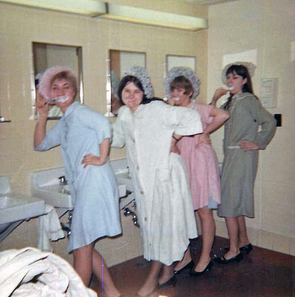
You do crazy things in college and spend the rest of your life saying, “It was college, for heaven’s sake!” Why would we decide to smear our faces with toothpaste, wear our shower caps as if they were high fashion fascinator hats, put on dress heels and flats with our bathrobes, and get someone to take our picture? Crazy, but fun. That’s me on the left, then Eileen, Becky, and Susan.
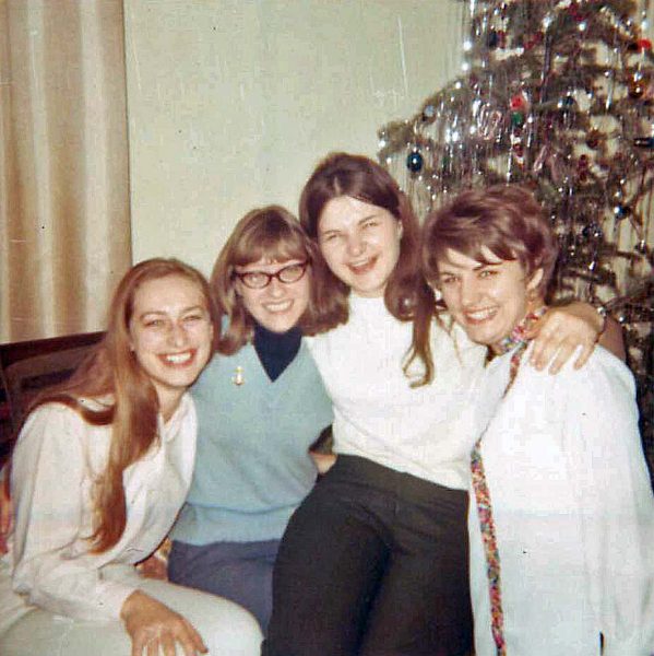
I loved my college years, but my senior year was the most fun of all. I shared a house in the summer with three former dorm mates. In the fall, we moved to a bigger house and added another dorm mate plus a friend of Eileen’s. The six of us had a ball and we still keep in touch and get together. Here we are at Christmas. Barb isn’t in the picture because she got married on December 21. We all kidded her about it being the longest night of the year. It looks like we had a Charlie Brown Christmas tree, but I remember we had a ball decorating it. Left to right, it’s Leila, Carol, Eileen and Lin. I took the picture.
The late 1960s were a politically active time on American college campuses. UC Berkeley and UW Madison were among the most active, with regular protests against the Vietnam War, including protests against Dow Chemical Company, which produced agent orange, a carcinogenic defoliant used in the jungles of Vietnam. In February 1969, there was a campus protest against Dow, and I guess it was expected to be unusually violent (by 1960s standards, not by today’s protest standards). I didn’t want to go to jail or get beat up, so I didn’t participate in protests. I attended my early morning class and was shocked when I left the classroom and saw National Guard troops with rifles standing in every hallway. I’d never been that close to a soldier with his gun ready to use and I was frightened.
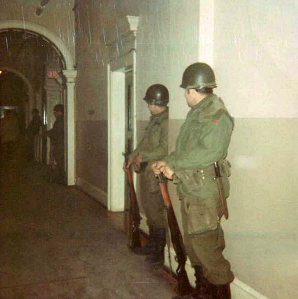
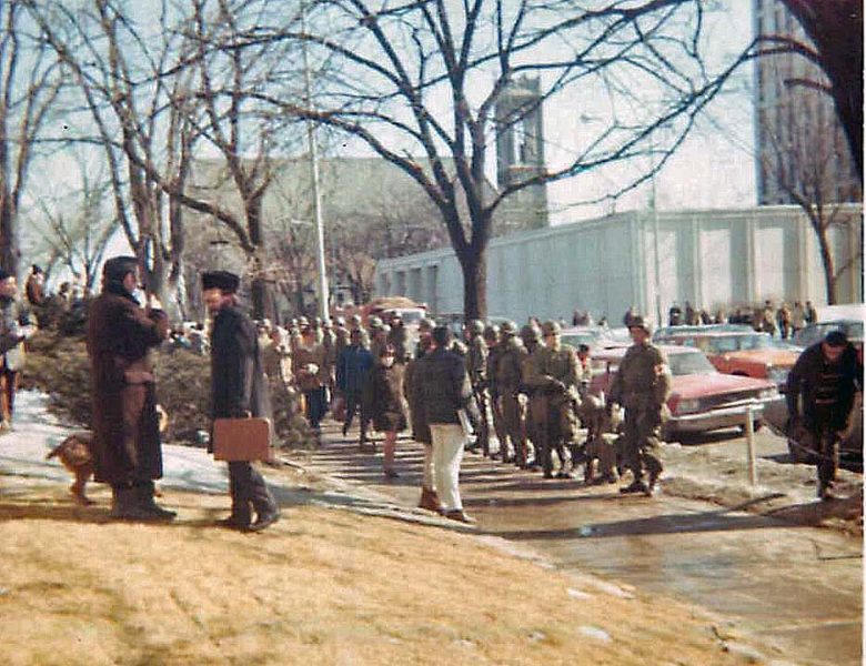
On the way to my next class, this is what I saw–more armed National Guardsmen standing shoulder-to-shoulder on the southern boundary of the campus. After class, I headed home for lunch. I had to cross University Avenue to get home to the house I shared with the other five women. By that time, the four-lane street had been closed to traffic and there wasn’t a car in sight. The guardsmen were more scattered, standing farther apart. With no traffic, I assumed the guardsman at the corner would be happy to see a non-threatening person (me) leaving the campus and carrying nothing but books. Wrong! As I stepped off the curb, the guardsman stepped directly in front of me, raised his rifle with a bayonet attached to it, and pointed it at me only a few feet from my chest. “Get back on the sidewalk!” he shouted. “I’m only going home for lunch,” I squeaked. He looked both ways (no cars in sight) and said, “Then wait for the light.” So I stood there on the sidewalk and he stood there at the curb with his bayonet pointed at me until the “Walk” light came on. Then I legally crossed the empty, deserted street and went home for lunch. I think I skipped my afternoon classes, or maybe I didn’t have any that day.
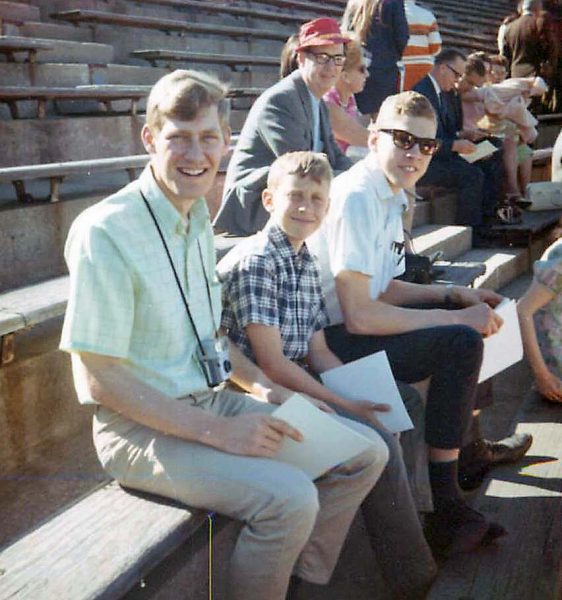
Time moved on, things calmed down, and June 10, graduation day arrived. My parents and brothers and my Grandpa L. came to watch me graduate, and so did Ted, who was working at the Weather Service Forecast Office (WSFO) in Washington, D.C. at the time. Here are three of my four brothers at my graduation–Denny, Russ, and Steve.
There were thousands of graduates and it was quite an efficient, if meaningless, operation. We were called by schools, so I walked with the School of Education students. You knew it was your turn when you heard “School of Education” on the loudspeaker. No individual names were called, and that was a good thing with so many graduates. The line never stopped moving. We walked toward the stage in a random group, received a quick handshake from everyone along the way (don’t stop or pause as you pass), and returned to our seats carrying an empty red faux leather folder for the diplomas that were mailed to us later. The picture of the graduation ceremony (below) was taken by my mom. Graduates (in black) are seated in the lower rows of the stands. I have no idea where I am in the crowd and maybe Mom didn’t either. I assume she timed the shot to at least show the School of Education graduates with our light blue tassels.
Graduation was held in Camp Randall, the UW football stadium. You can see the field and some of the stands on the other side in the picture below. As I mentioned earlier, football weekends were fun times. Students could buy season tickets for a pretty low price, and it seemed like everyone turned out for the games. I don’t think it was about winning or losing; it was about going somewhere that was a lot of fun and only incidentally watching UW lose the game. Seniors and grad students got the best tickets, so when I went to a game with Ted in my senior year, we sat near the front of the stands on the 40-yard line. As a freshman, I was at least two-thirds of the way up on the bottom level and probably on the far side of the 30-yard line. I remember having to look away to the left to see the cheerleaders. Camp Randall seated 70,000 people and was sold out for every home game. In contrast, Lambeau Field, where the Green Bay Packers play, only seated and sold out 55,000 seats at that time. Yes, football weekends were great!

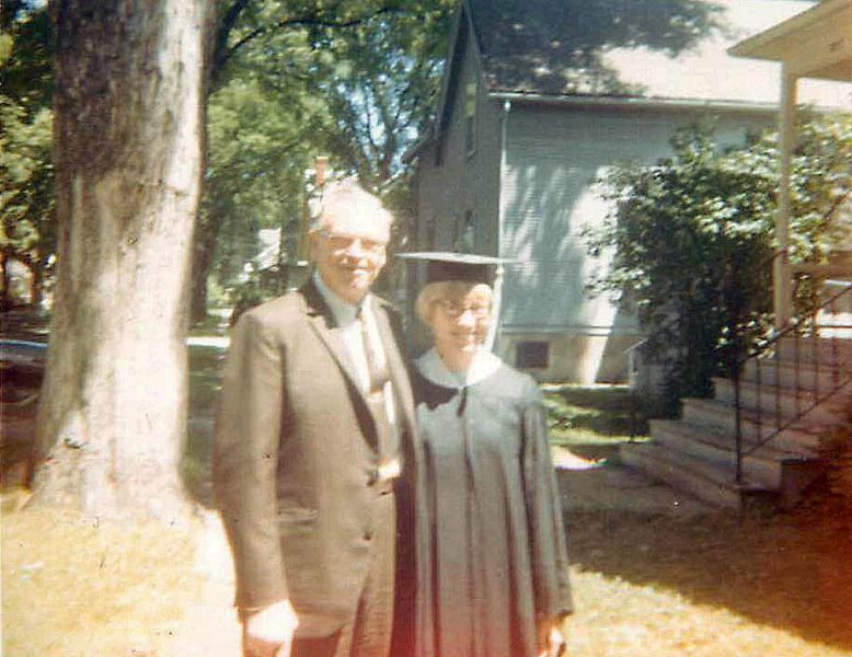
Grandpa wanted a picture with me in my graduation regalia. Our six-woman fun house porch and steps are on the right. Can you believe Grandpa and my dad wore suits to a June graduation where they had to sit in the sun on bleachers?! So did the other adult men in the pictures above. Dress codes for graduation ceremonies have certainly changed over the years.
Four days after my college graduation, Ted and I were married and headed for Washington, D.C. where we were going to live. This is our first Christmas tree. It looks normal, although a little wide, but it was so full and so crooked that we couldn’t get it to stand up in any way that resembled straight. We settled for hiding a kitchen chair in the corner behind the tree, weighting the chair with lots of Ted’s Encyclopedia Britanica volumes, and tying the tree to the back of the chair. You can’t see the chair through that thick Christmas tree, but you can see my sewing machine cabinet on the right. I bought it used during my freshman year in college and I still use it. The picture on the wall was my first gift from Ted. It’s a watercolor of Lombard Street that he bought while he was in San Francisco the summer we met.
Ted and I learned our lesson. When we moved to a larger (two-bedroom) apartment, we bought an artificial tree for our third Christmas. It stood nice and straight. By this time, we had accumulated some furniture. Pole lamps were in style, so we had one of those. The picture on the wall is one that Ted bought when he was on R&R in Japan during his Army service in Korea. We bought the black and white TV to watch Neil Armstrong and Buzz Aldrin walk on the moon. When we bought it, I said to the salesman, “Doesn’t it even come with a stand?” He went into a back room, came out with a stand, and gave it to us for nothing. The drapes cover an entire wall where we had sliding doors to a balcony. I made the drapes on my sewing machine, sitting at the sewing cabinet in the previous picture.
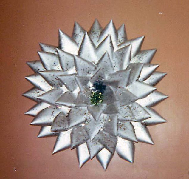
This was the time of data punch cards and everyone with access to discarded cards was making Christmas wreaths out of them. I worked at the Bureau of the Census and the Bureau was tabulating the decennial census by computer for the first time ever. Did I have access to used punch cards? More than you can imagine. Here’s my punch card wreath, sprayed with silver paint, decorated with sparkles, and highlighted with a sprig of artificial greenery in the center. Very vogue in the early ’70s.
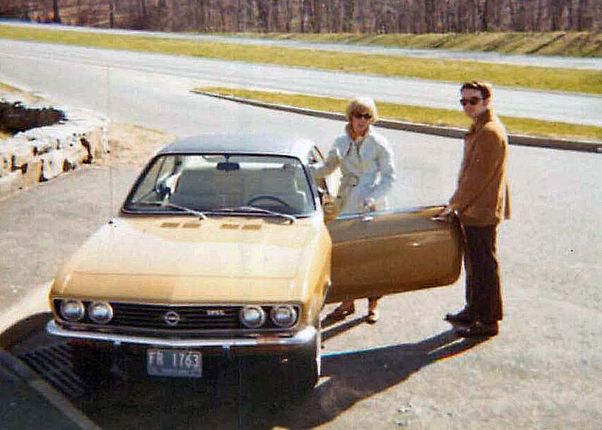
When we got married, Ted was driving a 10-year-old Pontiac Bonneville tank he bought when he was discharged from the Army. The heater didn’t work, so we had to cover our legs with a blanket in the winter. In Spring 1971, we bought an Opel Sport Coupe with the big engine–2.2 liters. The small model had only a 2.0 liter engine. That extra 0.2 liters made a difference, right? The car cost $2,200 and it was awesome! In all the time we had it, it only needed one major repair. The head gasket blew off when the car was 14 years old and it was a $400 repair. We debated whether or not the car was worth the money, but since it hadn’t cost us more than regular maintenance (oil, filters, tires, etc.) for 14 years, we fixed it and drove it for three more years. By that time, the brakes were failing and the clutch was so worn out, you had to start the car in second gear. Ted and I could manage that, but Jeff was 16 by then and he was learning to drive. We didn’t think it was a safe car for a 16-year-old to use, so we replaced it with a used Nissan Stanza. We never saw many Opels in the U.S. but we lost count of how many we saw in Germany when we were there.
A little over a year later, it was time to buy a car seat for the Opel. I was pregnant with Jeff and wanted a rocking chair to rock the baby. We bought this chair at “the world’s most unusual lumberyard” where they sold more than raw lumber. It was unfinished, so I stained and varnished it The stain and varnish cans are sitting on the floor. On the right, you can see the bookcase that held the encyclopedias we used to hold our first Christmas tree upright. When the varnish on the chair was dry and the chair was ready to use, I made a seat cushion and a back cushion for it (with my sewing machine at the sewing cabinet, of course). I rocked all four kids in this chair and it’s still in excellent condition in our upstairs library.
I think that’s all the photo history I have of myself–elementary school, high school, college, and marrying Ted. The next phase of Ted’s and my lives is raising our children. Good times, all the time.
I’ve had three photo albums sitting on my desk for months, waiting for me to go through them to scan some more photos. The first album has photos of me from my parents’ albums. The second album includes photos I took when I got my first camera–a hand-me-down Kodak Brownie Reflex from my mom when she bought a new camera for herself. The third album has Kodak Instamatic 110 mm pictures beginning with my college years and ending when Ted and I were first married–four days after my college graduation.
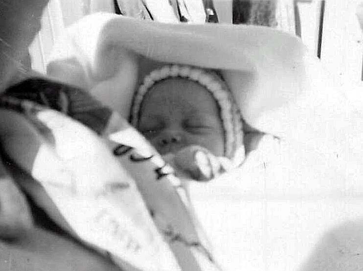
Let’s start at the beginning. Like David Copperfield, I am born. Here I am at one month old. What a cute baby!
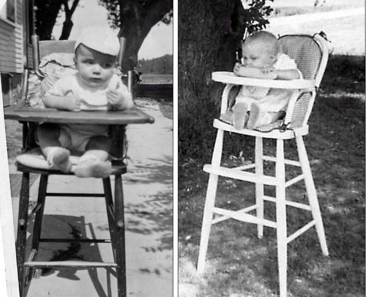
Ted and I obviously had similar interests in our first year of life, even though we didn’t meet until 20+ years later. Bringing the baby’s high chair outside for the picnic must have been the thing to do in those days. Ted is on the left; I’m on the right, several years later. The difference: my family actually gave me food!
Here’s how I took a bath when I was a baby. I remember the “bath table” from when my younger brothers used it. When the cover was down, it was a changing table. See all the diapers below the basket? It also has handy pockets on the front for diaper pins, baby’s hair brush, etc. With the top up, Mom could put water in the basket, bathe the baby, then open a plug and drain the water through an attached hose. It seems more complicated than bathing the baby in the kitchen sink, but nobody asked me for a better idea at the time.

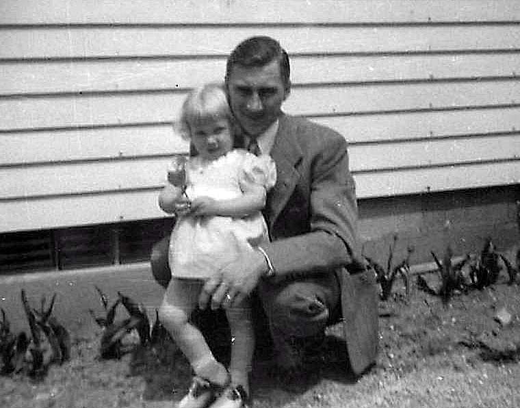
I remember people telling me I was “Daddy’s girl,” but I never really thought I got special treatment for being the girl. Maybe my four younger brothers would disagree. I don’t know–I’ve never asked them. I always thought I had it tough because I was the oldest and my younger siblings seemed to get away with a lot of things I didn’t as my parents eased up on some of the rules.
When my oldest brother, Denny, was born, I stayed at Grandma’s house while Mom was in the hospital. Mom’s younger sisters, Shirley and Ruth, still lived at home. They played with me and hung a swing for me from Grandma’s washline posts. Here I’m on the phone, talking to Mom about my new baby brother. Grandma lived in the city and already had a telephone with a dial. It was several more years before we got a telephone with a crank out in the country.
My mom–like everyone else–had a wringer washing machine when I was little. I used to “catch” the clothes as she ran them through the wringer. On my third birthday, I reached too close and my left hand got caught in the wringer. You can see the merchurochrome on my hand. That was the year I got a tricycle for my birthday.
From the time I started first grade, I’ve always loved school. I learned not to flaunt my love of learning when, during the summer before second grade, I mentioned to my friends that I couldn’t wait for school to start again. They were aghast! None of them liked school and they made fun of me for saying I did. I think I was about eight years old when I first heard someone talking about getting a doctoral degree. “Wow!” I thought. “You can keep going to school that long?” That’s when I decided I’d like a doctorate. Receiving my doctorate and being hooded by Dr. Henschke was a high point in my life. My love for school might have started when I was at least four years old. Here I am at my Aunt Ruth’s high school graduation and already practicing for my own graduation day(s).
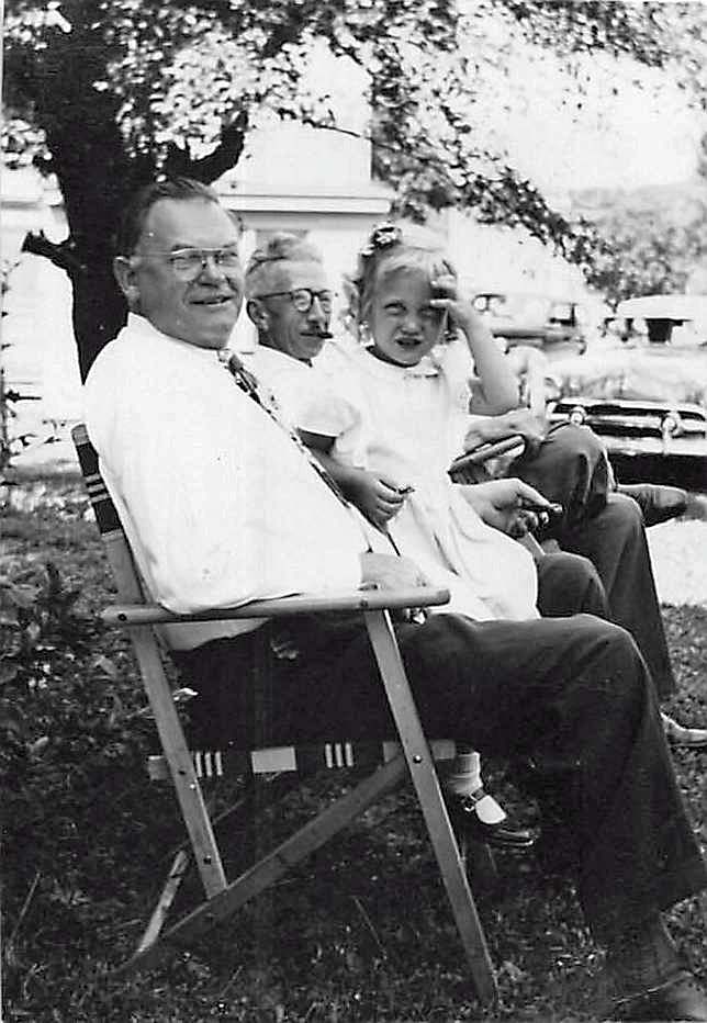
I think I was four when this picture was taken. I’m sitting with my two grandpas.
When I was five years old, I was the flower girl in my Aunt Shirley’s wedding. My Aunt Ruth was the maid of honor. Here we are before leaving for the church. I still wonder why Aunt Shirley picked lavender for Aunt Ruth’s dress and light green for mine. Really?? Purple and green??
My elementary school had about 50 students in eight grades. Ted’s was smaller, with about 20 students–6 of whom were his siblings and cousins. Ted’s was a true one-room schoolhouse, so I tease him that I went to school in town (population: 200) where we had two–and later, three–classrooms. On your birthday, it was the general rule to invite all the girls in your classroom (i.e., half the girls in the school) to your party. I was in 5th grade here, so these are the girls from the fifth through eighth grade room. Only Colleen (dark hair, lower left corner) and Mary Beth (behind Colleen on the left side, back row) didn’t go to my school. They went to parochial schools. Colleen’s mother and my mother grew up together and were best friends, then were pregnant with Colleen and me at the same time. Colleen and I have always said we were friends before we were born. Mary Beth was in my Sunday School class.
I’m in the center front row beside Loita, a Mexican girl whose family were migrant workers. Loita taught me my first Spanish sentence: Mi casa es blanca–My house is white. Her older brother, Onesimo, was 16 years old and in the eighth grade. I don’t know what happened to Loita, but Onesimo became a Wisconson Supreme Court judge.
As I look at this picture, I could probably tell a story about every one of the girls, but I won’t.
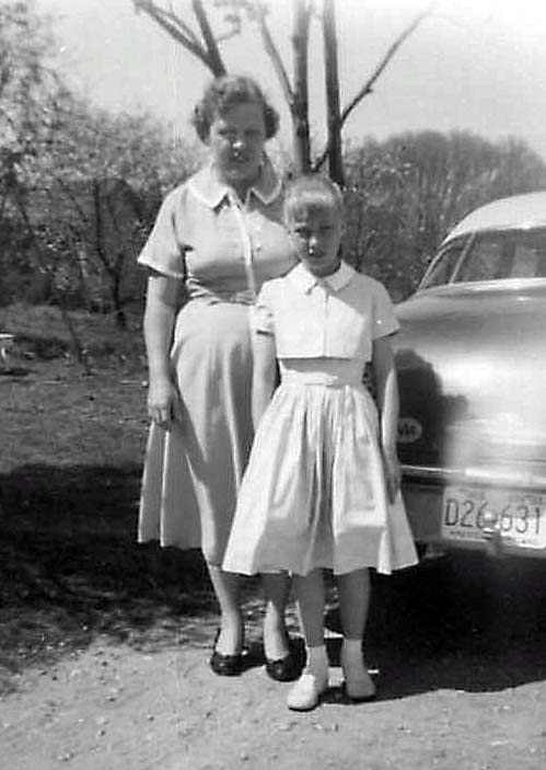
It’s summer and I’m going on a picnic with the other three girls in my fifth grade class. I’m on the left and then it’s Ruth, Judy, and Lynn. Fashions have certainly changed! Those halter tops are a thing of the past, and that’s probably a good thing. Look at our footwear! Not flip-flops or sandals, but leather buckle shoes or Keds with socks. We didn’t have a city park in my little town, so “going on a picnic” meant taking our bikes and riding to some farmer’s field, spreading a blanket on the ground, and eating our lunch. Look for cow-pies before spreading the blanket! It looks like it was my turn to bring the blanket.

Kids were eligible to join 4-H when they were ten years old, so I did, and so did all my ten-year-old friends. We had a boys’ 4-H club (the Handy Helpers) and a girls’ club (the Wide Awakes). I was named the Outstanding 10-Year-Old Girl in the county that year, based on the activities I described in my 4-H Record Book, which I still have. That’s the Outstanding 10-Year-Old Boy beside me and the two older honorees are the Key Award winners. You had to be 15 to be eligible for the Key Award. This picture was printed in the local newspaper.
This was the time when poodle skirts were in style. A poodle skirt was made of a full circle of felt fabric with a poodle appliqué on it. If you spun around, your skirt would flare straight out. A hem would have turned downward, so felt had to be used because it’s a pressed fabric and doesn’t ravel. My mom was an expert and superior seamstress. When I was growing up, you could sew a very nice garment for about one-third the cost of purchasing it, so a lot of women in our town brought patterns and fabric to my mom and she sewed clothing for them. She also sewed one-of-a-kind garments that a friend of hers marketed to a high-end clothing boutique in Chicago. Anyway, Mom made my “poodle” skirt. Unfortunately, I think the pattern included a design for a horse appliqué instead of a poodle, but I never minded. It was the concept that counted: full-circle, felt, and appliqué.
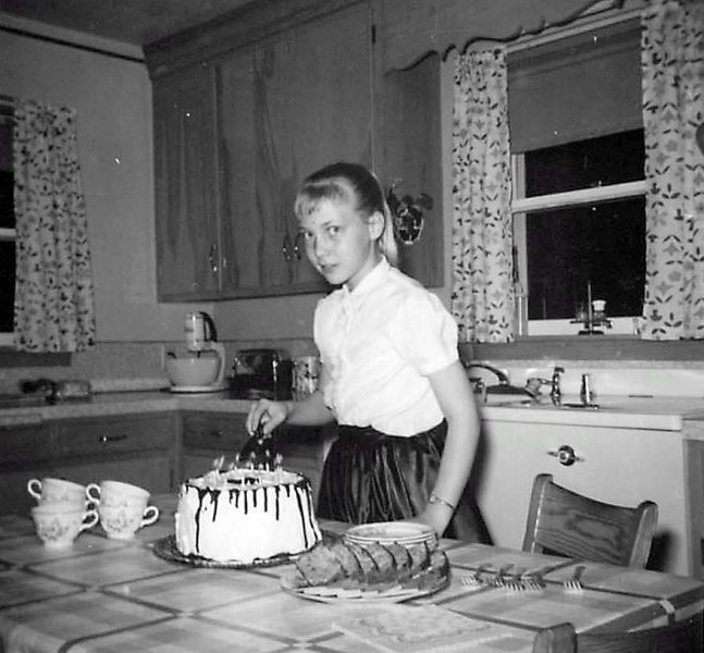
Here I am on my tenth birthday. I loved the skirt I’m wearing. It was a full skirt and made out of taffeta, so it swished when I walked. Awesome! Hey, kids, do you recognize the cake? Yes, that’s the well-known Vienna Torte my mom always made for my birthday and for my brother Tom’s birthday because we both liked it so much. I’ll be making it again for my birthday this year–as always. Check out the kitchen décor–curtains, stand mixmaster, woodcut trim above the sink and–ta-da!–one of the two automatic dishwashers in our town (the white appliance behind me with a flat top that lifted to load the dishes). The wooden kitchen chairs pre-date the faux-marble Formica top tables with chrome trim and legs, complete with matching chrome and vinyl chairs. We had one of those kitchen sets later on.
My mom was the oldest and my Aunt Shirley and Aunt Ruth were the youngest of six siblings. That made my aunts old enough to go to proms and formals when I was young/old enough to play “dress-up” with their used party dresses. It was one of the things my friend Nina and I liked to do. After we were all dressed up, we would walk a block to the local grocery store and buy some candy for a penny or a popsicle for a nickel. We just knew everyone who saw us would admire our fancy dresses. You can do that kind of thing in a small town.
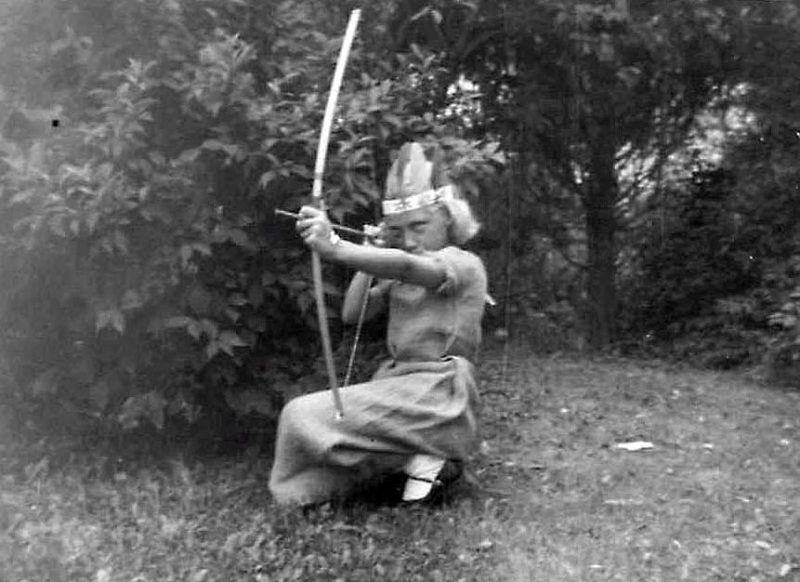
In fifth grade, we must have studied American history because we had to dress as our favorite historic character. I remember Kathy had to do the same thing when she studied Missouri history. Kathy dressed as Laura Ingalls Wilder. Do you recognize my character? That would be Sacajawea. I think one of my brothers had the bow and arrow set. My “dress” was made out of a burlap potato sack (washed, of course) and decorated with painted macaroni and spaghetti noodles. I doubt that Sacajawea was blonde or ever wore burlap and noodles, but it made sense at the time. I still remember how scratchy it was.
Like me, my mom was usually the one who took the pictures, so I don’t have many of the two of us together, but here’s one. Naturally, we’re both wearing dresses that Mom sewed.
Remember how I said I went to a small school? Here’s a school picture of the sixth, seventh, and eighth graders when I was in sixth grade. I just showed this picture to Ted and said, “Can you believe this is three grades of kids?” He scoffed and told me that, when he was in sixth grade, his school had only seven kids in those three grades. Yes, Ted, but I went to the big school in town.
Here I am in my eighth grade confirmation dress and heels, holding my new hymnal–the traditional confirmation gift. My dress is my favorite shade of blue–made by Mom. Confirmation was always on Palm Sunday in those days. This might have been examination day, the week before confirmation. On examination day, members of the confirmation class had to answer random questions from the pastor about what we learned in catechism classes about the Bible and church doctrine while the rest of the congregation watched and listened. It felt like high stress, but I don’t remember anyone ever flunking examination Sunday and being turned down for church membership. Transitioning from eighth grade to high school used to mark the age when a girl changed from bobby socks to stockings (cf Frankie Avalon) and from flats to high heels. I remember when Kathy modeled her confirmation dress and heels, Thom (nine years old at the time) said in awe, “Kathy looks like a lady!” That age is certainly when you begin to move from childhood to adulthood.
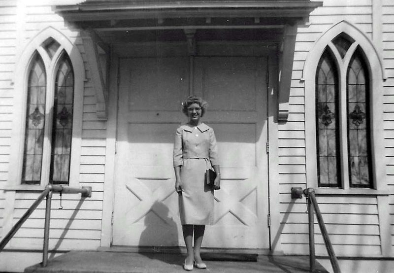
This is surely confirmation Sunday, because I’m in a white robe and I have a pink carnation corsage. We’ve got all the obligatory poses. First, with my parents, . . .
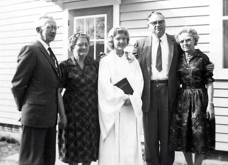
. . . and then with my grandparents. That’s G & G S. on the left and G & G L. on the right.
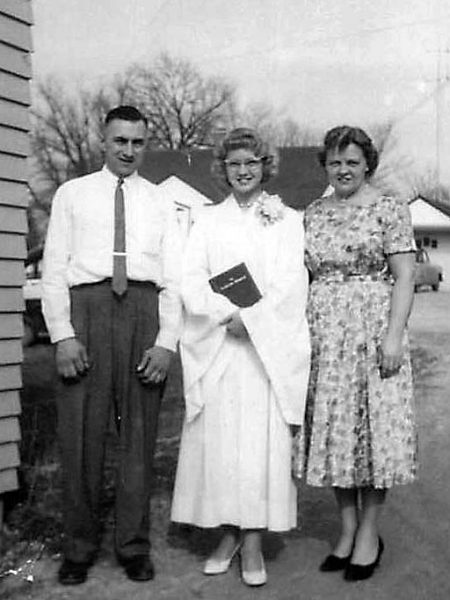
Last, but not least, we have me with my sponsors (godparents), Aunt Jerry and Uncle Gibby.
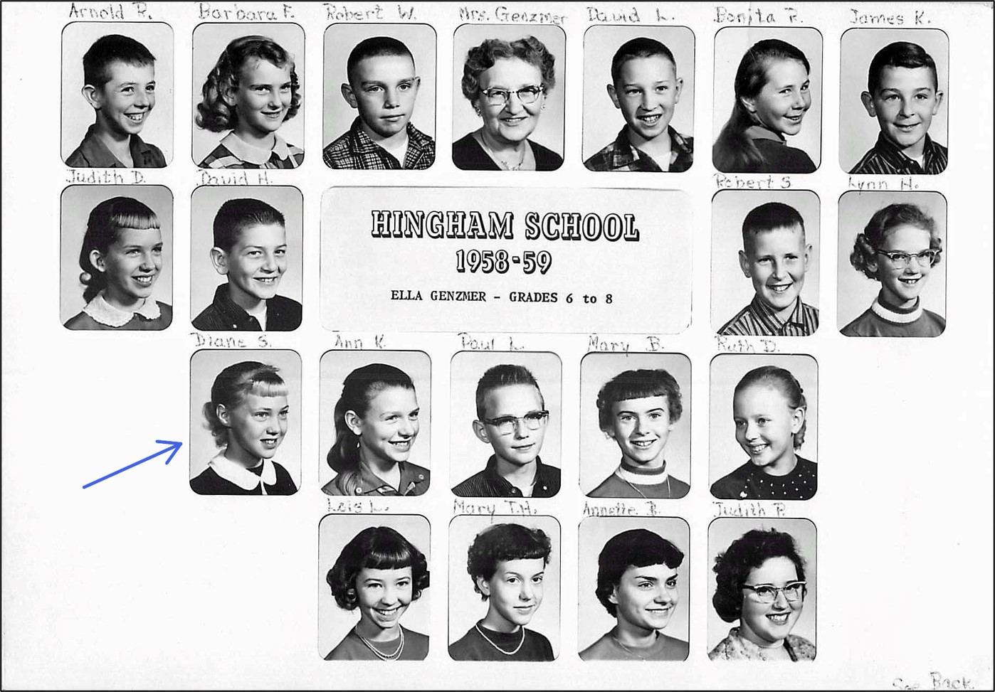
After confirmation, the next big highlight is eighth grade graduation. Here’s my seven-member eighth grade class, the largest class to graduate from my school at that time. Our official photographers were our mothers. The teacher was Mrs. Genzmer. In all of my school career–elementary school, high school, bachelor’s degree, two master’s degrees, and a doctorate–I have been fortunate to study with four teachers who could easily be named the National Educator of the Year every year. They exemplified what it means to be a teacher, and they were: Mrs. Genzmer (elementary school); Mr. Meyers (high school physics and advanced math); Dr. Zeni (masters program, English); and Dr. Henschke (doctoral program, adult education).
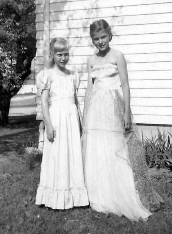
The last photo from these two albums shows me in my junior-senior prom dress just before my high school graduation. Naturally, Mom sewed my dress. I went to the prom with David, my steady boyfriend at the time. We thought we’d get married, but we broke up at the end of the summer. Ahh, young love.
Next time: The College Years
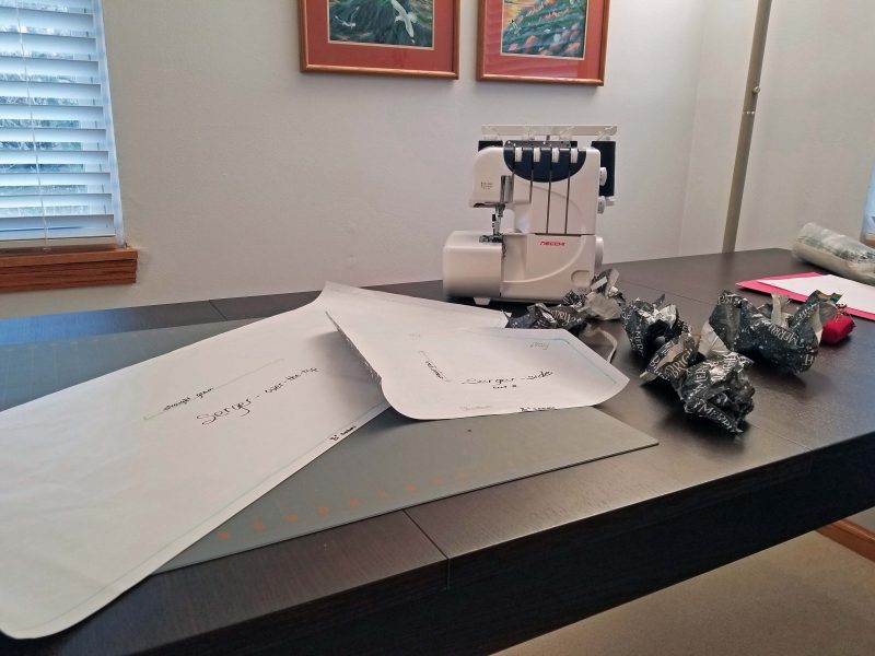
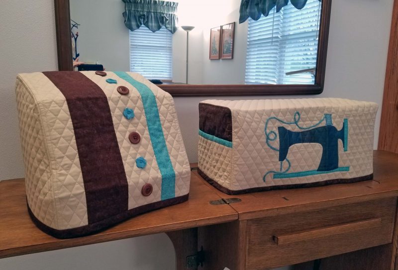
Now that my sewing machine cover is finished, I’m on a roll and decided to sew a cover for my serger as well. We had five rainy days in a row, so it was a good indoor project. My sewing machine came with a made-to-fit case, but my serger was sold in its birthday suit, so it needs a pretty dust cover.
Drawing a pattern for the serger was more of a challenge than doing that job for my sewing machine. My sewing machine is basically block-shaped, so I only needed to measure the dimensions of the block, then draw two rectangular pattern pieces.
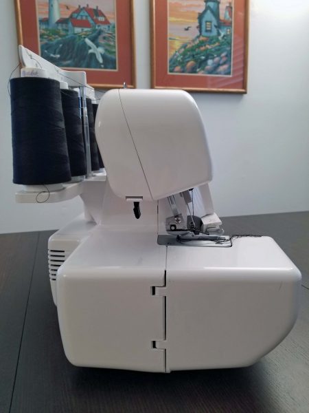
The serger, on the other hand, is–let’s say–“irregularly shaped.” That sounds nicer than “weird.” The spool stand and thread holder extend beyond the hand wheel on the right side of the machine. The cloth plate extends beyond the upper body of the serger on the left and in the front.

The top of the serger is offset from the bottom, and the back of the top is higher than the front. I can let the back side of the cover hang from the thread guide (the white top bar), but if I make the front square like a box, the upper part is going to sag. Where does one put the ruler to measure an odd shape like this?? I set each extended section against a wall and measured outward from the wall.
The next step was to translate those measurements into a flat paper pattern. I drew the long, over-the-top piece first, because that was the easy part. Then I had to take my height, width, and whatever measurements to draw a side piece that would shape the over-the-top piece to my serger. I drew and cut out a side piece and held it up against the serger to see if the angles and corners were in the right places. They weren’t. After a number of tries, I eventually got it right. It’s a good thing I have a lot of this ugly gift wrap left on the roll.
Ok, I’ve got a pattern, but what will I do to make the finished product more attractive than the plain fabric I’m using for the cover? This was my original decorative idea (thank you, Google), but it’s a sewing machine cover and my serger is too narrow to attach a fabric band, then sew the word “Stitch” large enough to be read from more than a foot away.
I got out my box of scrap fabric and tried different ideas, including decorative pockets. The fabrics weren’t necessarily the colors I wanted to use; I was just looking for a design style that appealed to me. My plan was to worry about the details after I created a design I liked. BTW, creative design is not my long suit, so don’t laugh.
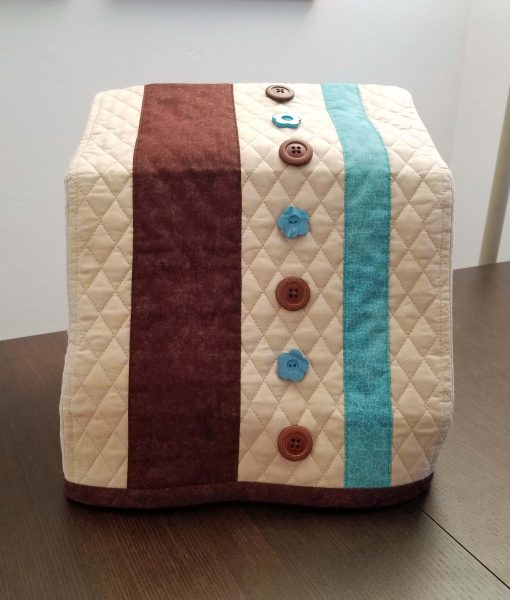
This process took hours. I finally set it aside to ponder the problem overnight. The next day I asked myself why I was trying so hard to come up with a new idea. I really like the colors I used on my sewing machine cover, so why am I avoiding using the same colors to make a coordinated set of covers for my two machines?
The answer: Because I used scraps for my sewing machine cover, so I’d need to buy more brown and turquoise fabric. I was trying too hard to avoid shopping for fabric when I have a boxful of scraps. I didn’t have any suitable large buttons in my button box either, so I had to buy buttons too. When I did, I finally felt good about sewing my serger cover pieces together.
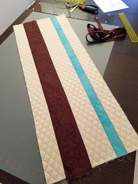
My sewing machine cover had two 90-degree rounded corners on each side that needed clipping and notching; my serger cover has a 90-degree rounded corner at the back and two angles on the front that needed clipping and notching on each side. I edge-stitched the seams to keep them flat. Just like with my sewing machine cover, I cut some extra length on my fabric because it’s easier to trim it off than to add it later. I’ve got to start trusting my measurements. Again, just like with my sewing machine cover, I needed to cut off the extra length I added.
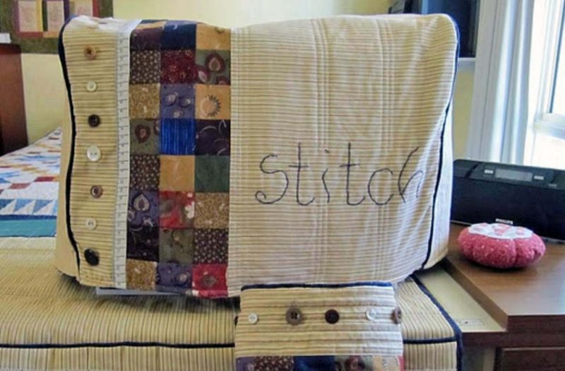
When I finished the cover, I was very pleased. The fit is perfect, all the corners and angles are in the right places, I like my decorative design, and I like the colors. I also like having a coordinated set of covers.
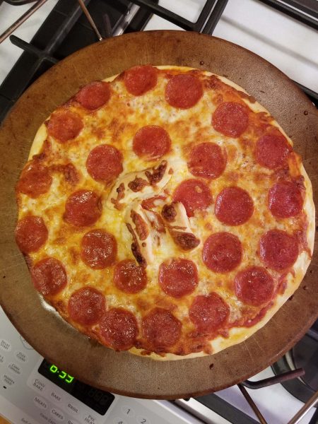
If you missed it, look for the Greek letter in the center of the pizza.
2020 kept all of us close to home and, as a result, inspired many homeowners to improve their property in a variety of ways. Yesterday, Ted and I couldn’t help noticing that our usual walking route is becoming increasingly kitschy. This might be a sign too much time at home.


The gnome lover in the last photo has barely begun, compared to what Ted and I saw in Townsville, Australia. Shhh! Don’t tell the neighbors where to buy more gnomes!
Before–March 7.
After–March 14.

Ten consecutive days of warm, sunny weather have added signs of spring to Ted’s and my walking route: green-again grass, tulips and daffodils beginning to bud, one patch of daffodils in full bloom, magnolia trees budding and beginning to bloom, and red maples dropping their red blossoms on the streets where we walk.
Spring is the best!
In early February 2020, Ted and I scheduled our next overseas vacation. Our plan was to arrive in South America on February 14, 2021 and to return home on March 16. Our first scheduled destination was a few days in Peru, including an excursion to Machu Picchu. After that, we were going to cruise our way around the continent, stopping in a variety of places in Chile (including Patagonia), Argentina, and Uruguay. Today, we would have been in Buenos Aires, and tomorrow we were scheduled to return to Patagonia for an additional five days in that area. Thanks to the pandemic, our travels this year were far more modest. The farthest we’ve been from home since we returned from Australia on January 15, 2020 was Kirksville, MO where we spent a day with Kathy and Annette in August.
This is beginning to look tempting.

I know this pain. The cure? Avoid reading book series; stick to stand-alone stories.

P.S. Once I read a book review that said something like “A new Jude Devereaux book is out. There’s a late night ahead.” Yes, I’ve done that, and not only with Jude Devereaux.
luxury–noun; (1) the state of great comfort and extravagant living; (2) hot tub.

Definitely (2) hot tub.
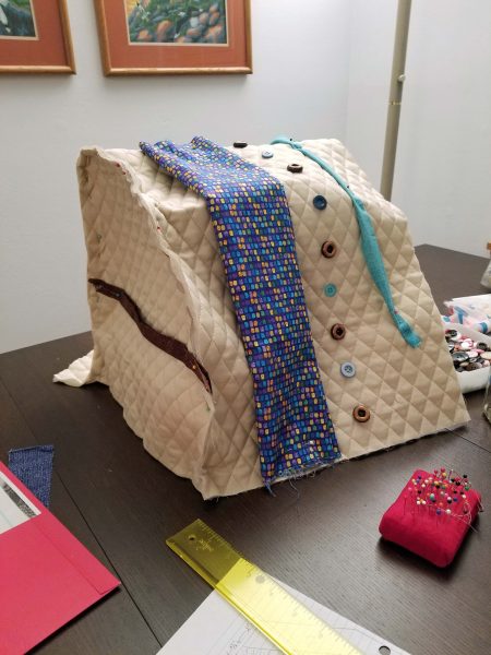
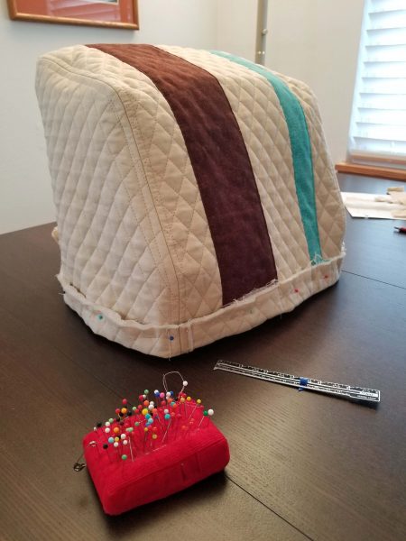
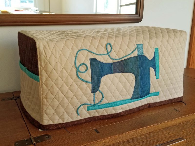
When I bought my sewing machine (December 2016), I also bought some fabric to make a cover for it. Do I have a cover for my machine? Of course I do–a matching custom-fitted carrying case came with the machine–but when I’m working on a project and want to leave my machine out for a few days or weeks, I want a simple dust cover to drop over it. I decided the time has come to dig out that four-year-old piece of fabric and make my dust cover. After mulling over ideas for a few days, I searched online for patterns and designs.
I couldn’t find anything closer to a pattern than “how to measure your sewing machine,” so I had to be a bit more creative than I’d planned. Not that sewing a basic box to fit over my sewing machine is that complicated. There were serious (?) decisions to be made, however, such as whether to make the long piece fit over the top of the machine from side to side or from front to back (I chose front to back) and how to make the finished product a little more exciting than a blah fabric box.
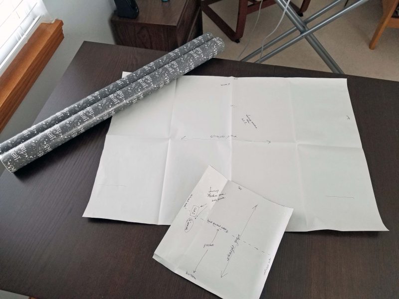
Ok, we are go to sew. I measured my sewing machine as directed and created a pattern (a large rectangle and a small rectangle–woo-ee!). I even remembered to add seam allowances, and I measured generously for the hem on the theory that it’s easier to cut an inch off than to add an inch if it’s too short. I didn’t have paper large enough for my over-the-top piece, so I used a roll of Christmas gift wrap that I don’t like.
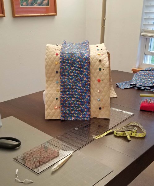
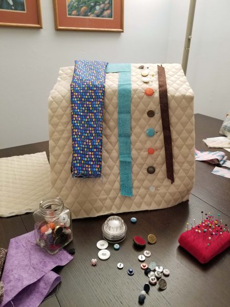
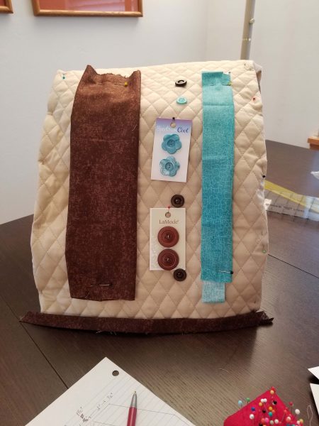
Pockets or not? Because I keep all of my sewing tools in the drawers of my sewing machine cabinet, I doubt if I’ll ever need pockets on my dust cover to keep my tools handy. On the other hand, I can make the pockets decorative and–who knows?–maybe someday I’ll wish I had them. It’s easier to include them now than to add them later. I added contrasting fabric above the pockets and bound the top edges of the pockets with colorful bias tape to give my cover a little pizzaz. I decided to divide one side pocket into two smaller pockets for smaller tools, just in case I ever want to store them above my cabinet.
My fabric is plain, so how will I liven up that large rectangle? In what colors? I decided to appliqué the silhouette of an old-fashioned sewing machine to the front of the cover. I had to do another internet search for an old-fashioned sewing machine image that was “straight-on” so I could graph it to the size I needed for my appliqué. Then I pinned the appliqué in place to see if I liked it. I did.
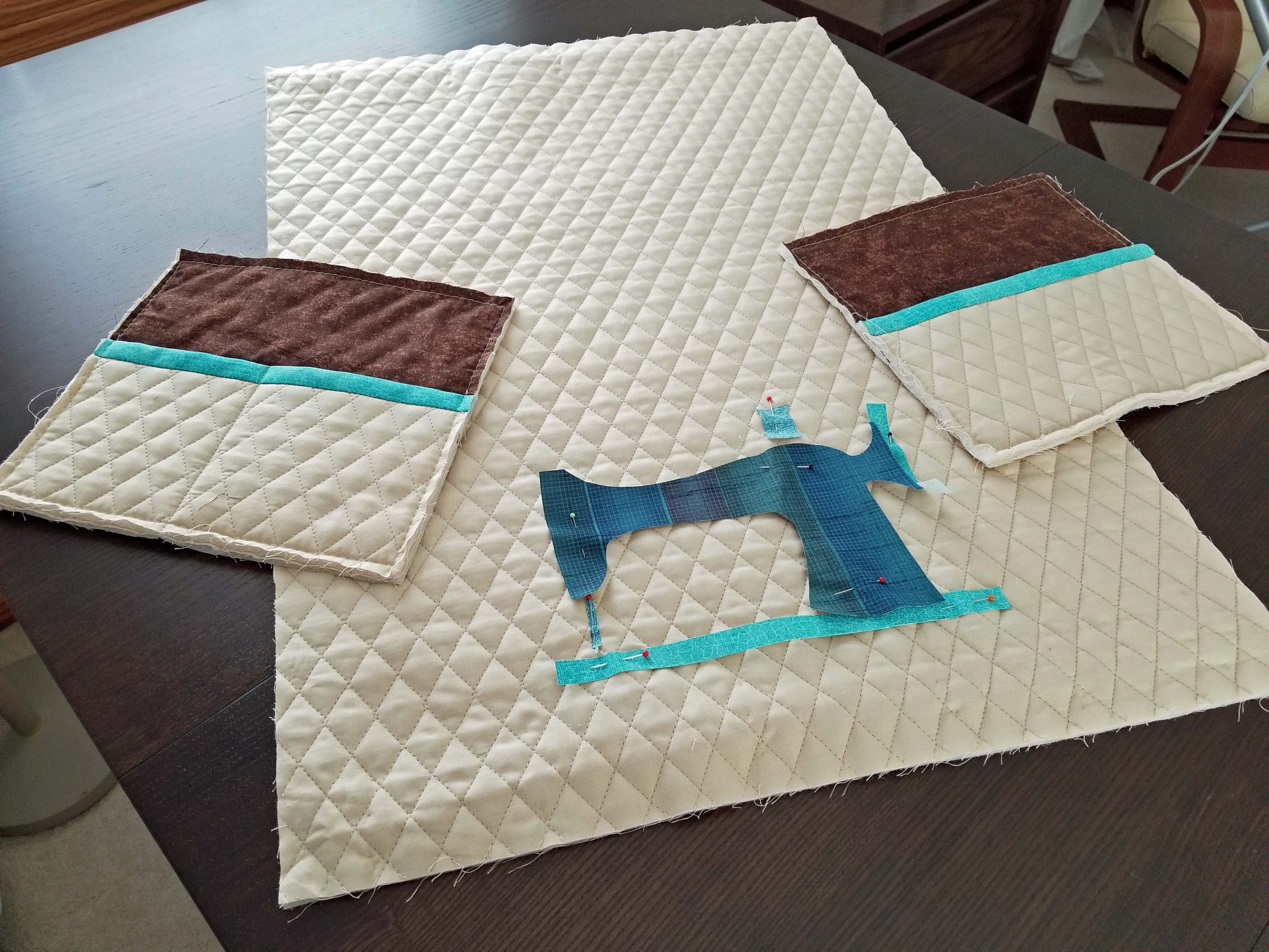
I pinned the three pieces together to make sure they were the right size. There’s that extra inch I added at the bottom. I’ll cut it off after the second fitting session when the pieces are actually sewn together.
That looks good. I had loads of fun (hah!) sewing those tight rounded corners at the tops of the pocket pieces. Clipping and notching was needed big-time.
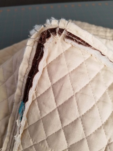
To keep the seams flat on multiple layers of quilted fabric, I edge-stitched on each side of the seams.
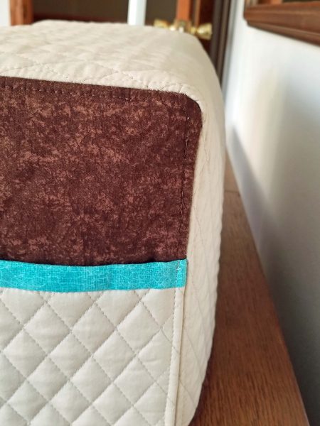
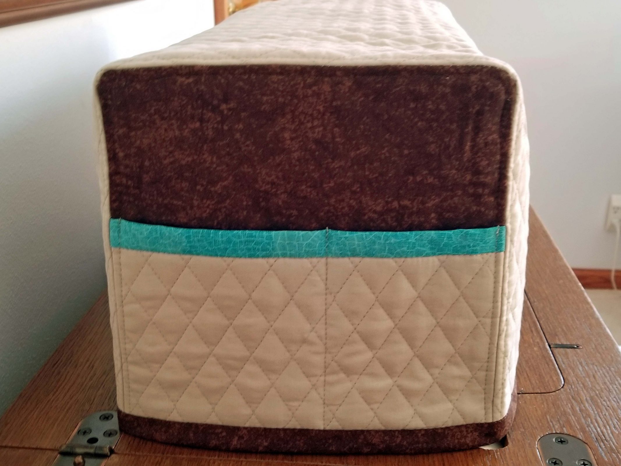
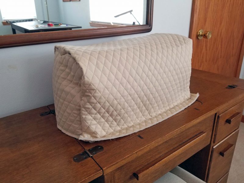
Then I cut the cover to the length I needed and decorated the bottom edge with bias tape made from the same fabric as my pocket tops. Last, I ironed the appliqué in place and attached it with a zigzag stitch. HeatnBond can’t be beat for appliqués. (That was hard to type. It should be Heat ‘n’ Bond. Yeah, grammar nerd here.) I added a piece of yarn “thread” for a whimsical effect. Voilà! I like it!
Oh, happy day! It’s definitely spring. Temperatures are in the 60s and Ted and I saw tulips along our walking route.
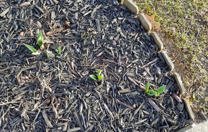
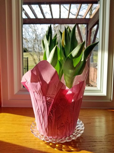
Ted made a trip to the hardware store this afternoon and he also made an unscheduled stop to buy me his traditional spring gift. He knows how much I love spring. There are six yellow tulip buds in the pot and I’m looking forward to every one of them.
Is it any wonder I keep hanging out with this guy?
I’ve had both of my COVID vaccinations and Ted has had his first. We were lucky in scheduling our vaccinations. Our doctor’s health system contacted us and provided a number to call. When we called, we were scheduled within a few days and when we had our first inoculation, we were immediately scheduled for the second one to be administered in three weeks. From what I’ve been reading, the scenario below is more common.

This reminded me of how Ted and I felt last week when we wanted to go out to lunch.

Maybe federal regulation of utilities isn’t all bad. Texans suffered greatly during the recent winter storms, due in large part to planning and operational failures among Texas utility companies.

Each of us has our own individual skill set. Is it common for people to wish they had different skills, or is it just me? I wish I had more creative skills. For example, I’m an excellent technical writer and can easily write a one-sentence summary of nearly anything, but I wish I could write a creative story. I played first chair clarinet in my high school band and I later took piano lessons, but I wish I could play more musically rather than note-by-note. I can make changes to just about anything changeable to meet the need, but I wish I could come up with the original idea.
I never recognized many of the skills I have until I became an adult and realized that I can effortlessly do some things that other people struggle with. From across a room, I can spot a crooked picture hanging on the wall. Once I took a level to a picture that Ted thought was straight and showed him that it was off by 1/8 inch. I’m very spatial as well. I can eye up a room and tell you whether or not a given item will fit in the space available. When my GED classroom site was moving, I worked with the campus facilities director to move the furniture and set up the classroom in the new space. After looking around the room, I told her where I needed to have things placed. The director later told me she was amazed that everything fit on the first try. On a smaller scale, I can look at a pile of stuff and stack it in the most efficient way in the least amount of space in no time at all. Once, when we had overnight guests, I decided to leave the dishes until later. One of the guests commented that she’d never seen that many dishes in such a small pile. I’m also excellent at organizing things. It’s no problem for me to examine a task and decide what should be done first and what will be needed to do it.
So what’s my problem? My discontent is that these don’t seem like skills to me and, even if they are, they’re dull and boring.
Today I was reading LaVyrle Spencer’s book, Years, and recognized another skill of mine. The characters in the book are dealing with the aftermath of a terrible blizzard in North Dakota in the 1910s. Two family members are missing and a search party goes to work in the dark. When they return to the house in the early morning, we learn that “It was clear Nissa hadn’t slept at all. It was equally clear that she was one of those who functions well under stress, whose thought processes clarify in direct proportion to the necessity for clear thinking.” That is so me! I tend to get frustrated by little annoyances, but in a crisis, I’m probably the person you want. If it’s an emergency or a big deal of any kind, my mind clears, a calmness comes over me, and I can see exactly what needs to happen and who I should direct to do what.
As I read about Nissa, I thought, “That’s actually a great skill to have.” I probably just need to recognize how my boring skills are practical and generally make my life easier. And yet, I can’t help wishing . . . .

It’s been over a year since our Pilates classes were cancelled due to the community college closing at the beginning of the COVID-19 pandemic. That was our first sign that COVID was getting too close to us for comfort. Ted and I have been very careful to avoid becoming infected by this awful virus. We started wearing masks as soon as the CDC recommended that practice for prevention; we have practiced social distancing; and our hands are the cleanest they’ve ever been. We have a very small social bubble, and we get a little bit excited if we need to cross the line into St. Louis County for something–about 10 miles away.
The National Weather Service recognizes March 1 as the first day of meteorological spring. Therefore, spring has sprung! The sun is shining, and Ted and I just felt like we wanted to go out for lunch to celebrate. We haven’t eaten in a restaurant since March 16 last year–the day before the total lockdown started. (I had a lunch and a dinner coupon for free birthday meals and I didn’t want to waste them.) We ordered a take-out pizza once last summer, but the ambience of eating it in the car just didn’t measure up to sitting in the restaurant. I like to cook, so I’ve actually enjoyed preparing meals at home, but still, . . . . Did I say it’s been a year???
We decided that we’d celebrate the first day of spring by making something for lunch that we would have ordered in a restaurant. We (used to) like the grilled cheese sandwiches at Panera, so we made grilled cheese and French fries. Instead of our usual milk as a beverage, we blew our healthy diet and had Pepsi. To change things up a little, we decided to eat somewhere different from the kitchen table. It was only 52 degrees outside, so we chose the basement as our setting–someplace different than we’re accustomed to. We named our casual restaurant Unser Haus.
It wasn’t crowded, so social distancing was easy.
There were people chatting at the bar, so there was a little crowd noise.
We were seated in a booth, and the food was good.

Best of all, it’s the kind of restaurant that provides a chocolate after the meal.
Yes, it was a self-serve restaurant, but it was fun to do something different.
Yesterday, Hasbro announced that it is neutralizing Mr. Potato Head. Hasbro’s senior vice president and general manager announced, “The way the brand currently exists—with the ‘Mr.’ and ‘Mrs.’—is limiting when it comes to both gender identity and family structure.”
The outcry was loud:
Dr. D exclaimed, “For crying out loud–it’s a potato! It doesn’t have a gender!”
Media analyst Mark Dice tweeted, “It’s time for the Republican states to secede.”
Piers-Morgan tweeted, “Who was actually offended by Mr Potato Head being male? I want names. These woke imbeciles are destroying the world.”
Steven Colbert’s segment on Hasbro’s announcement asked, “What part of this do you see as gender-based?”
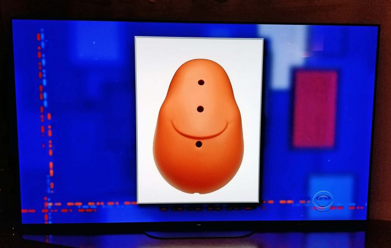
Sean Hannity tweeted, “MR POTATO HEAD 1953-2021, Hasbro: He Was ‘Limited When It Comes to Gender Identity’.” After Hasbro clarified that only the “Mr.” is being removed from the name and that Mr. and Mrs. Potato Head will be continue to be available as “just plain ‘Potato Head’,” Hannity responded, “Mr. Potato Head Lives!”

Long live non-gender potatoes!
Author’s note: When I was growing up, our Mr. Potato Head toy required actual potatoes; thus, the name of the toy. Complaints about rotten vegetables plus new government food safety rules prompted Hasbro to include a plastic potato body along with the facial parts in 1964.
English is a living language and freely adopts and adapts words from other languages. Kathy and I (fellow English majors) were talking today about some of the colorful, folksy terms we use to describe people, specifically words that are difficult to define, but that “we just know” what they mean. Examples include klutz, ditz, putz, doppich, frumpy, and schmuck.
Today, while I was reading The Mystery of Mrs. Christie by Marie Benedict, I came across a new descriptive term: “twee.” In the book, Mrs. Christie speaks of her husband, Archie, and says, “I toned down my natural exuberance and chatter, because Archie found it cloying and more than a little twee.” I had no idea what “twee” meant, so I looked it up.

I like the word. The problem? It’s British slang, so if I use it, it’s unlikely my listener will know what I mean and I’ll have to figure out a way to describe a word that “I just know.”
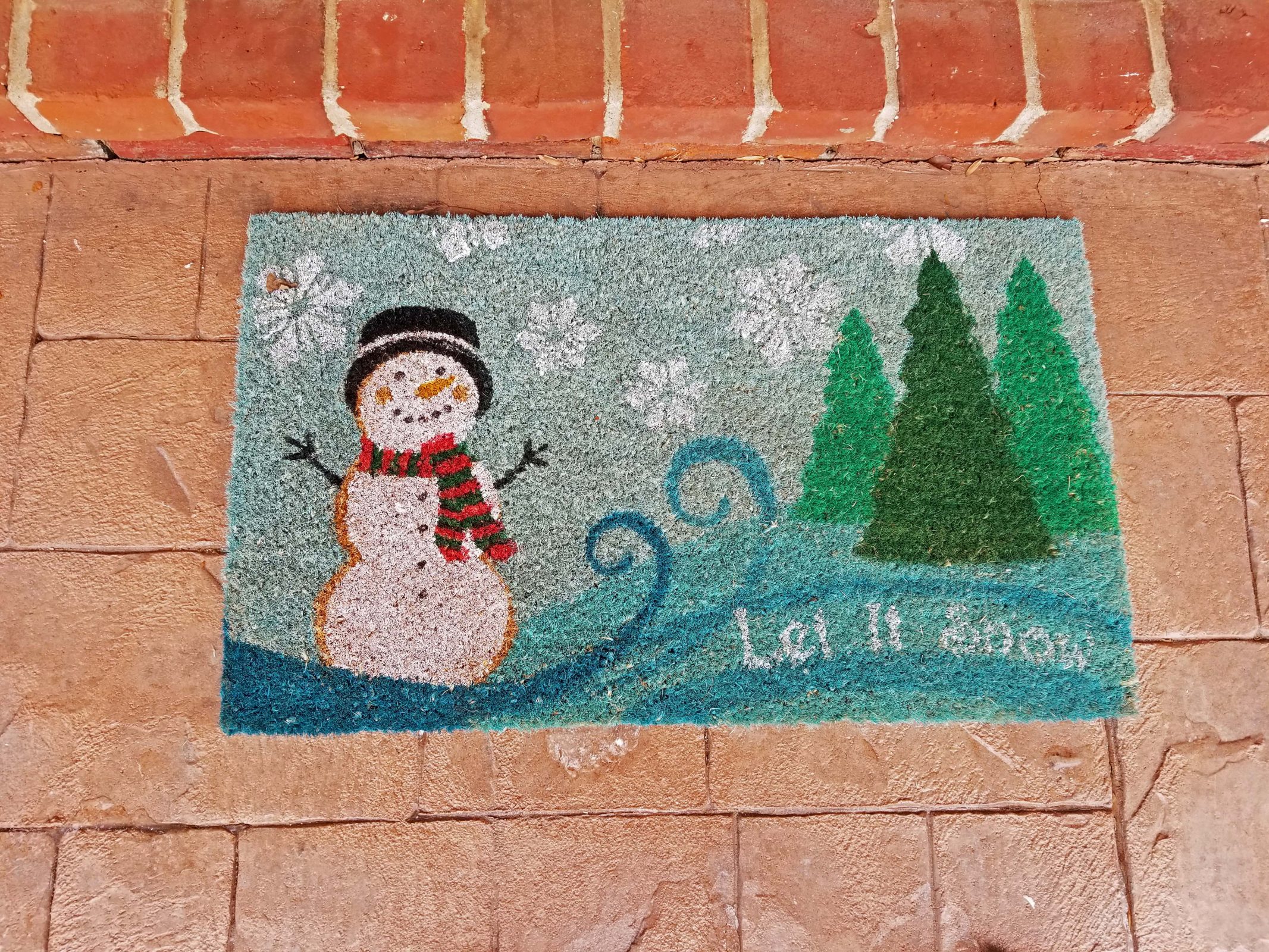
Here’s our winter doormat. Be careful what you wish for.
When our kids were little, it was normal for our area to have 6-8 snowfalls of 4-6 inches, as well as one or two snowfalls of 12-14 inches in a season. After 30 years of climate change, however, it has become more typical for us to have several snowfalls of 1-2 inches and maybe one or two snowfalls of 3-4 inches in a season. More snow than that in a single event is becoming unusual and, therefore, remarkable.
This winter has been a snowy one for a change. After a relatively warm November and December (we took our last bike ride on December 29), we had a few light snowfalls of an inch or less in January. Then the pattern changed. At one point last week, 46 states had snow cover on the ground. Florida, Georgia, South Carolina, and Hawai’i were the exceptions.
January 27. We had four inches of snow. Whoopee! I love using my snowblower and this was enough snow to make a snowblower worthwhile. It wasn’t too cold, so I had a good time. Then Ted took a turn and used the snowblower to clear Jim’s driveway. Jim and his wife are 90 years old and they appreciate the help.
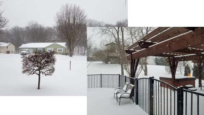
February 15. There’s a forecast for a major snowfall in our area. A big snowstorm always sounds exciting to me. There’s something magical about snow, and a heavy snowfall makes everything quiet and peaceful. It started snowing early in the day, but the flakes were tiny and didn’t accumulate much. By late afternoon, it started looking like serious snow. Our normal temperature at this time of year is in the mid-40s, but today we set a record for the lowest high temperature on February 15: 4 degrees. The previous record was 19 degrees in 1905. We didn’t just break that record–we smashed it! The wind chills were a vicious 25-30 degrees below zero. There went our dream of sitting in the hot tub while snowflakes romantically fell on us. It wasn’t a good day to go outside, but it was fun to watch the snow fall and to watch a movie with a fire blazing in our fireplace in the evening.
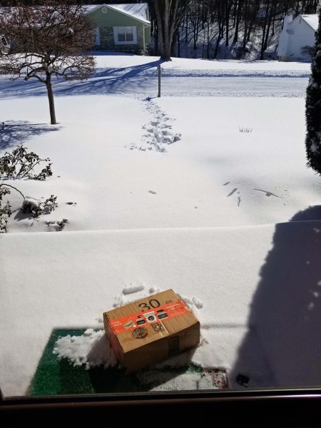
February 16. The snowfall ended, the sun came out, and we set another record low high temperature. This time, we made it to 5 degrees, probably because of the sunshine. The previous record was again set in 1905. Wind chills were still well below zero. It was so cold, the mailman didn’t even walk our package all the way to the door; he only went far enough to throw it to the porch. Luckily, it was a book and it didn’t break.
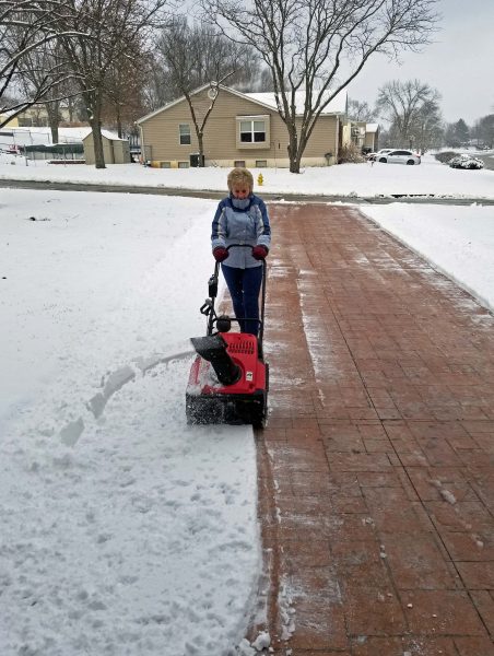
I bundled up in three layers of clothes and a sturdy pair of boots and headed outdoors, feeling like Ralphie’s little brother in “A Christmas Story.” My first task was to stick our trusty NWS “Snow? How much?” ruler into the snow to see how deep it was. Wow! Seven inches!

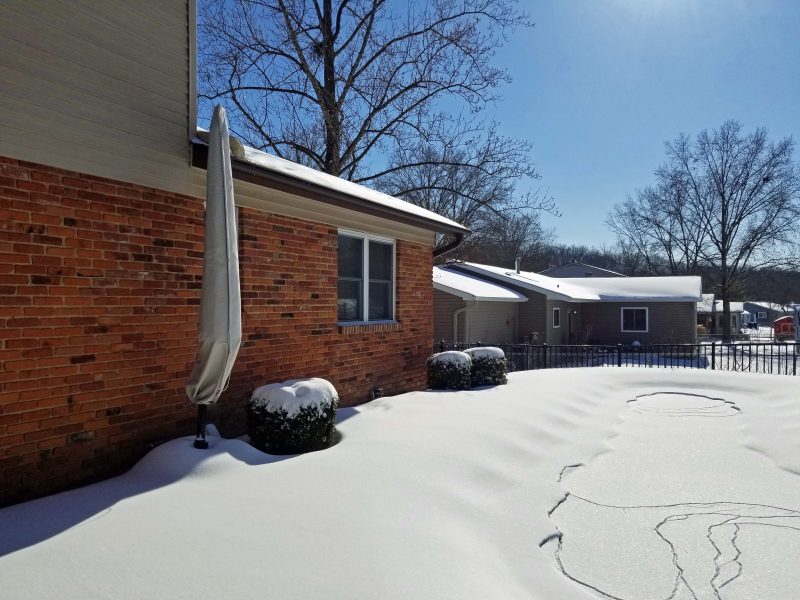
The weight of the snow made our pool cover sag, so pool water seeped through it and froze on the cover.
I took a few more pictures outside, but I could hear my snowblower calling my name, so I got to work. I always go up the middle of the driveway first so I can throw half of the snow to each side instead of having it all pile up ahead of my path on one side.
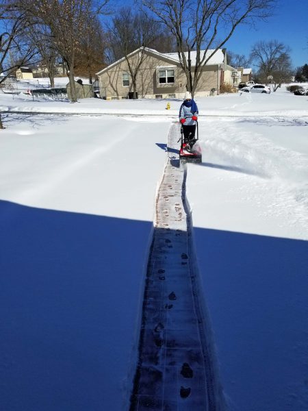
The sidewalks were a challenge. Because it was so cold and windy, the snow was light and the wind blew it across the lawn, making it impossible for me to see where the sidewalk ended and the grass began. The curves in our sidewalks added to the challenge of finding my way through the virgin snow.

The second pass was a little easier, but our snowblower is designed to work with a foot of snow or less, so 7 inches kept me going slowly to give my little machine a chance to blow a path for itself.
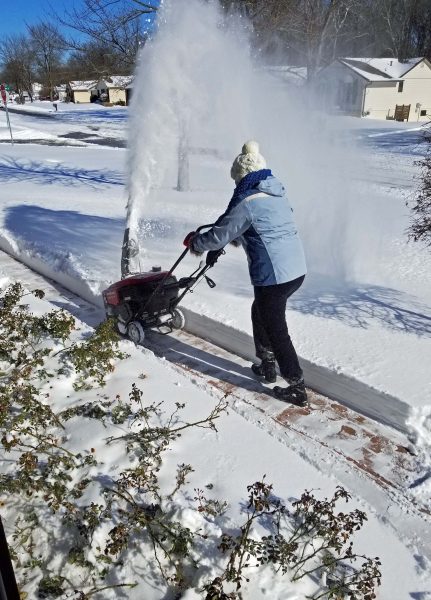
While I was using the snowblower, Ted was using a shovel to clear the places the snowblower can’t go–the back step, the front porch, and the corners. Two-and-a-half hours later, we had all of our concrete clear. Then we cleared Claudia’s driveway. Claudia’s husband died three weeks ago and we know she doesn’t have a snowblower. That was a lot of snow for her to have to shovel in a double driveway. Another neighbor with a snowblower cleared Jim’s driveway. Although it’s only 5 degrees, the sun is melting the snow residue on the concrete. Even a snowblower is hard work–especially with seven inches of snow to move. I was sweating by the time I went back indoors.

February 17. Guess what. We had another two inches of snow overnight. We got out the snowblower–again–and cleared all of our concrete–again. It was easier this time because (1) there was a lot less snow, and (2) yesterday’s paths were visible. It was still mighty cold, however. We had 14 days in a row with temperatures below freezing, and 10 of those days never got above 20 degrees.
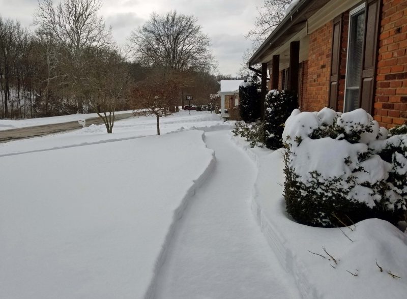
February 18. The skies dropped another inch of snow on us. The temperatures are warming up, however, and with the concrete warmed a little from the sun after we cleared it the last two days, we knew this last bit of snow would melt on its own.
February 23. Talk about extremes!!!! Eight days ago, it was 4 degrees; yesterday we warmed up to 58 degrees and today it was 71 degrees! You could almost literally watch the snow melt. By the end of the day, it was gone, except for a few places where the piles were deep or where there was shade.
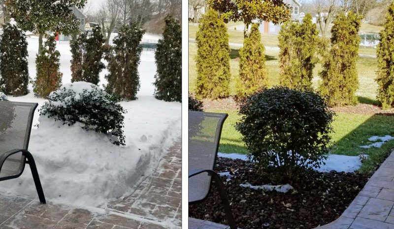

February 24. Today, it was 62 degrees–a little cool to put the top down on my car, but warm enough for Ted and me to take our walk in long-sleeved shirts without wearing jackets. With the snow out of the way, I can smell spring in the air. The snow was fun while it lasted, but I like warm weather much better than cold. Think spring!
Author’s note: Ted and I know how fortunate we are to be able to enjoy this major (for our area) snowfall with the luxuries of heat, light, water, and food. We give thanks for our blessings and offer prayers for those who are suffering because of the storms across the country, especially in Texas.
A local TV reporter presented a human interest story about today’s cold weather and heavy snow. In addition to the cold, hard facts (pun intended), the reporter interviewed some local people. The first person said he wished he hadn’t moved here from the Alabama shore. The second person said he’s loving it and “if it has to be cold, it should be painful.” It is. The wind chills are low enough to cause frostbite in less than 30 minutes of exposure.
The reporter told us there was no one sledding on Art Hill today (wind chills are 20-25 degrees below zero) and neither his car nor his cat would start this morning (video of sleeping cat). Local grocery stores closed early.
To amuse himself, the reporter decided to freeze some clothing. After freezing a wet sock flat on its side on the sidewalk, he used it as a boomerang. He also froze his T-shirt and jeans, but topped his flat clothing with a video of a woman’s dress frozen in 3-D (for lack of a better description) and standing on a porch. It looked like a scarecrow without a head.
The reporter closed by informing us that today’s temperature in Dallas is lower than it’s been in Anchorage all winter. Dallas had a high of 13 degrees today; Anchorage had a high of 23 degrees. Our official high temperature of 4 degrees today broke another 116-year-old record high for the second day in a row. The previous record for the day was (again) 19 degrees in (again) 1905. This time, though, we smashed the record by 15 degrees, not a measly 11 degrees like yesterday.
Our area has had temperatures below freezing for 10 consecutive days and there are 4 more days forecast to remain below the freezing mark. If we’re lucky, we’ll get into the mid-30s after that. Our normal high temperature at this time of the year is in the mid-40s and the daffodils and crocus shoots are appearing in flower beds. They’re probably hibernating under the snow this year. Polar vortex, go home!
Yesterday, February 14, St. Louis set a record low high temperature for Valentine’s Day. If you aren’t married to a meteorologist, that means the lowest high temperature on record or, in other words, as warm as it got. Here are the stats:
Previous record low high: 19 degrees, set February 14, 1905.
New record low high: 8 degrees, set February 14, 2021.
We didn’t just break the record; we smashed it! I’ll just mention that the normal high temperature on Valentine’s Day in St. Louis is 45 degrees.
Today’s forecast: 4-8 inches of snow. We’re right on the line for the heavy snow, so we’ll see which way the storm tracks.
A few days ago, I received an invitation to attend a Zoom baby shower for Kaitlyn, the mother-to-be of Ted’s and my first great-grandchild–a boy.
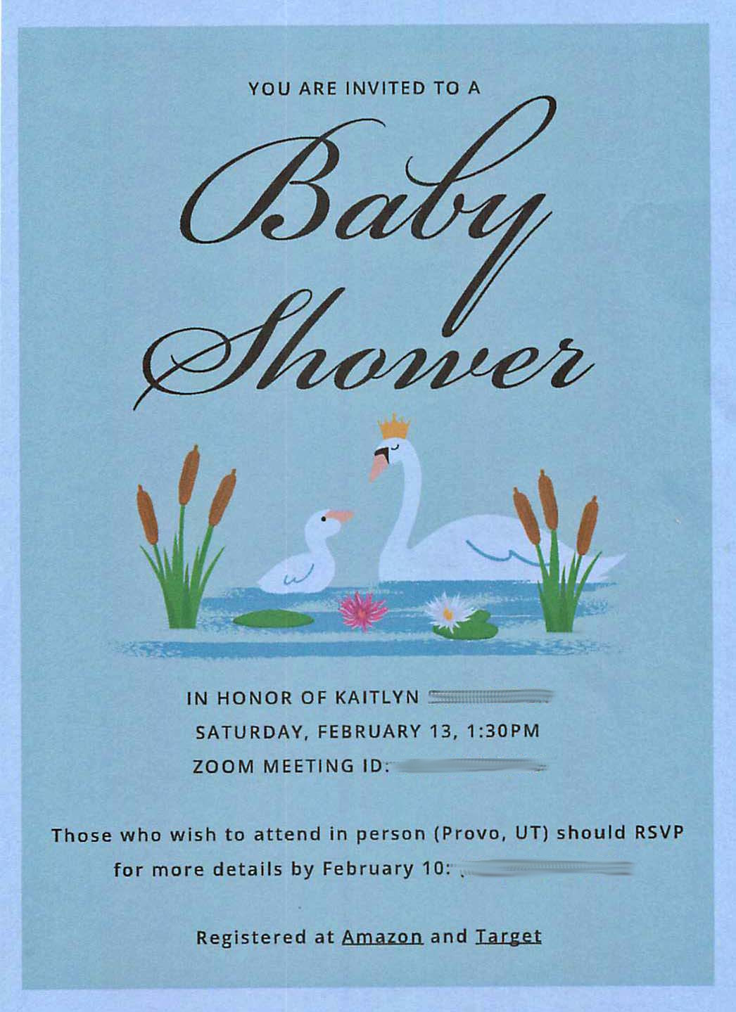

Today was the big day. People who lived nearby attended the shower in person; those of us living farther away logged into Zoom. Eventually, we had five Zoom participants and ten people at the house. We started with Kaitlyn opening gifts.
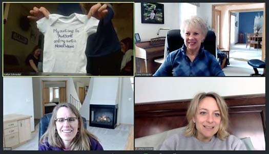
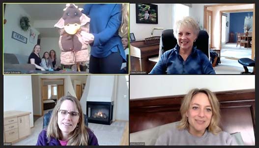
After that, there were snacks. You can see members of the house group (upper left of the Zoom screen, below) leaning over the table to grab some food and a beverage. The woman with the long blonde hair in the house group is Kyra. Kaitlyn is on the far left, facing the camera. One of Kaitlyn’s grandmas, her mother, and her sister were present at the house. The lady on the right in the lower right of the Zoom screen below is Kaitlyn’s other grandma. While the house crowd filled plates and cups, the Zoom crowd imagined snacks. La called me later for an after-shower chat and we agreed the food was delicious.
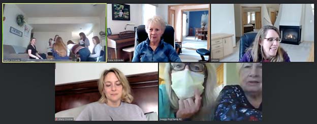
Then it was time to play the obligatory shower game. It was a version of “The Price Is Right.” We guessed the prices of a variety of baby items purchased at Wal-Mart. The item was presented in a close-up view at the camera and each of us gave our best guess. La and Shelley had the most right answers. During our after-shower chat, La admitted that she wasn’t exactly guessing; she had pulled up walmart.com on her computer screen and was looking up the items as they were presented. Checking Shelley’s line of vision (lower left of the Zoom screen above), she might have done the same. I admit that I thought of doing that, but I didn’t feel like going to the trouble.
As we were leaving the Zoom meeting, one of the house attendees told Kaitlyn to stand up so we could see her baby bump (below). Her baby boy is due just three days before my birthday. I will be thrilled if he is born on my birthday. If that doesn’t happen, I will be thrilled that I share my birthday month with my first great-grandchild.
I like seeing my family on Zoom better than just talking on the phone because it seems more like we’re really visiting each other. It was nice to be included in the baby shower, but it will be even nicer when this pandemic is history and we can get together in person again. I’m hoping that will be possible later this summer, so Ted and I can meet our first great-grandchild and our ninth grandchild before they’re all grown up.

While we waited 22 weeks for our replacement windows, Replacement by Anderson treated us to some delicious cookies “to help sweeten the wait.” After completing the installation, they sent us more cookies.
This time, the box clearly indicated the contents.
This time, they came in a nice cookie tin, not a simple plastic bag.
This time, we received a dozen cookies, five more than last time.
This time, they included the recipe. I’ll definitely be making more of these for us. Maybe you will too.