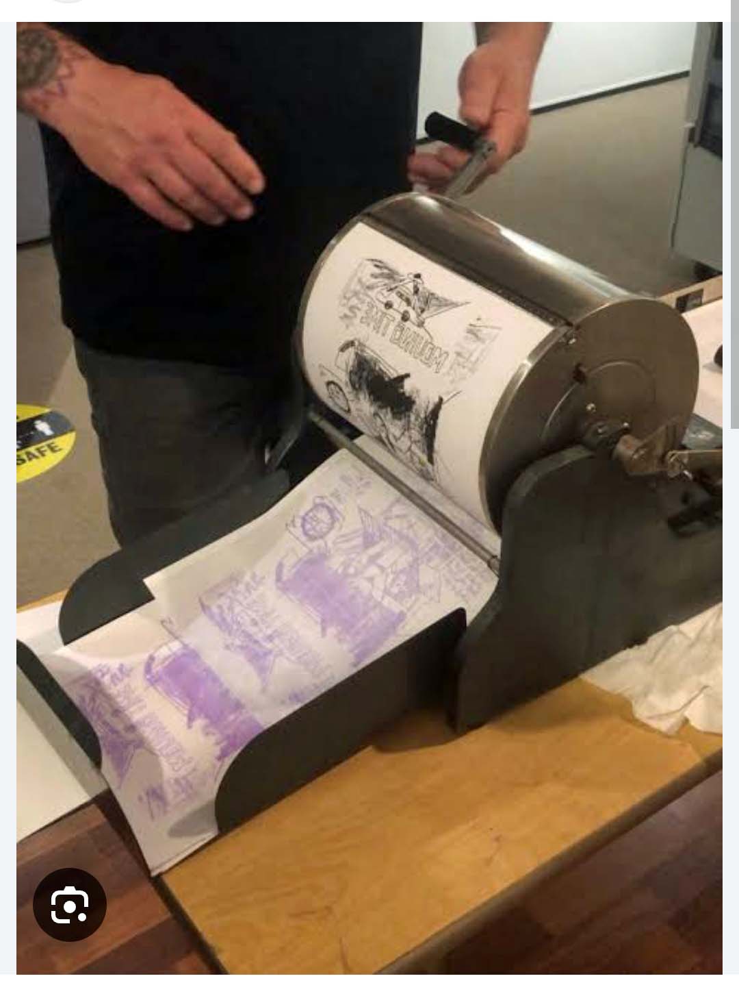
You can find anything online, right? Who documented all this old stuff, and who posts it for the rest of us around the world? Finding mimeographed copies of my elementary school newspaper on Facebook reminded me of the mimeograph and, not surprisingly, I found a photo of a mimeograph machine online.
The stack of blank paper to feed the machine is on the right in the photo below; the stencil is attached to the drum; the man is turning the drum counterclockwise to feed the paper under the drum; and the finished copy appears on the left.
My elementary school teachers used mimeographed worksheets for all of our classwork. First, they typed text or used a specially-designed electric pen to draw an image on a wax-coated paper stencil. The finished stencil had holes in it to allow ink to pass through to a sheet of paper. Our teachers always made the stencils but, sometimes, we students were allowed to make the copies. What fun to turn the drum and watch our worksheets appear! A single mimeograph stencil could be used for thousands of copies, allowing our teachers to save them in a file cabinet for re-use in the next school year.ier
Xerox was the first manufacturer of commercially successful copy machines. Instead of carbon copies or mimeographed copies, we called these “Xeroxes,” as in “I made a Xerox of that page so you’d have a copy,” or “Please make a Xerox of this for everyone at the meeting.” Xerox copies were more easily accessible, more affordable, and produced better quality copies than mimeographs or carbon. As a result, by the 1980s, the mimeograph machine was essentially obsolete, and new copier purchases moved on to Xerox machines.
Still, as one article I read said, the legacy of the mimeograph lives on, and it has a special place in the hearts of those of us (like me) who fondly remember it. When we see a sheet with purple print or drawings on it, we say, “That’s a mimeograph sheet! I remember those!”
Question: Who decided purple ink would be a good idea?
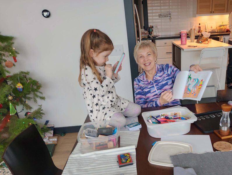
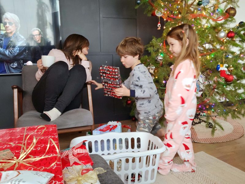
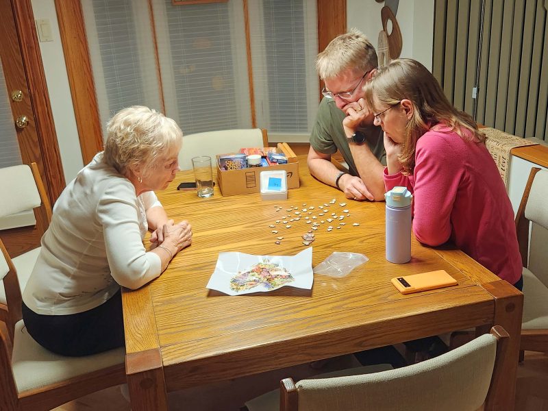
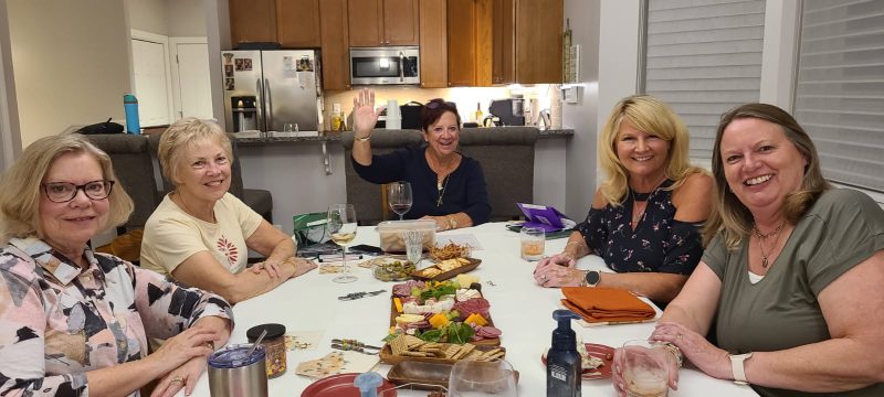
You know how sometimes, you’re looking for something in particular online and you accidentally come across something that grabs your interest? I don’t remember what I was looking for, but I came across a Facebook post that featured pages of my elementary school newspaper. I’m not on Facebook, but it was apparently a public page, because I could scroll through the entire thing. It was fun to read the “news” we reported in grade school and to recognize the names of the kids I interacted with every day in school (50-60 students in eight grades) and around town (population about 200). In such a small school, we didn’t have a newspaper staff. Everyone contributed to the newspaper, with sections dedicated to the primary, intermediate, and upper grades. I selected some pages to post here. Most of them include an article by one of my brothers or by me.
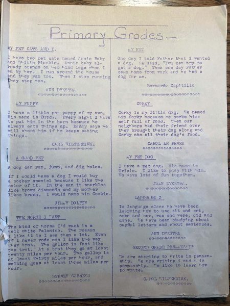
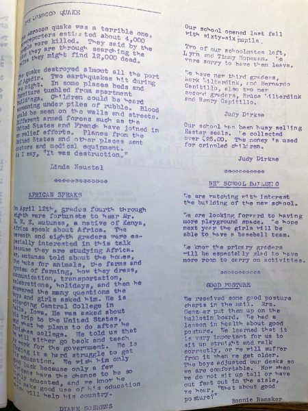
1#I don’t remember the name of the newspaper–if it even had one–but this is how the grade-level sections were labeled. For this edition, the primary grades were apparently assigned to write about their pets. We didn’t have a pet at that time, so the last article in the left column describes how much my brother, Steve, wanted a horse. FYI, there weren’t many horses on the nearby farms, and I never saw a Palomino, but Roy Rogers, a 1950s TV cowboy, rode his Palomino, Trigger, on his weekly show. Maybe that counts as seeing Palominos “a lot,” as Steve writes.
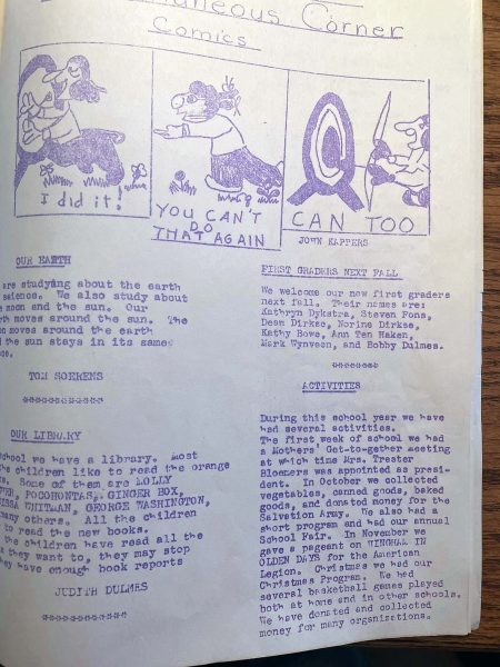
Tom, another one of my brothers and younger than Steve, wrote a short paragraph for the “Miscellaneous Corner” about the earth (first article, left column). It sounds like his class was studying the solar system. Note that the page, like a real newspaper, includes a cartoon, drawn by John Kappers, one of the primary grade students.
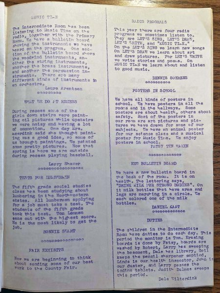
Denny, my oldest brother, wrote about the radio programs that provided the 1950s equivalent of online learning (first article, right column). Small, rural schools like ours could not afford specialized instructors so, four days of each week, our classrooms tuned in to Wisconsin Public Radio for an hour-long program and we followed the radio teachers’ instructions for singing (“Let’s Sing”), drawing (“Let’s Draw”), and writing (“Let’s Write”). We also had some music instruction (“Music Time”). I remember singing along with the “Let’s Sing” teacher, but I don’t recall “Music Time.” Online information indicates it might have included music theory information, and maybe a variety of musical styles (popular, classical, etc.) that we listened to. The article to the left (first one, left column) reports that we also learned about the musical instruments in orchestras.
In the last article in the right column on this page, Dale Wilterdink reports on who had which duties at school. The school janitor was always a woman from our small town (usually a classmate’s mom) who cleaned after school hours for a little extra spending money. Students were required to do minor duties after school to (1) assist the single janitor/schoolkeeper/mom and to (2) learn responsibility. Duties were assigned for either a 1- or 2-week period–I don’t remember which. I don’t think primary grade students had duties because I remember being in first grade and seeing Jimmy, an older student, clapping erasers outside after school to clean them. When Jimmy told me he was doing his duty, I didn’t have a clue what a duty was and I thought it might be a euphemism for a bodily function.
I still remember the African speaker we had at school one day. I wrote about him in the second article in the left column. Our area of Wisconsin was all white, so a person of color was a novelty. Not only that, but he was actually from Africa–a distant and exotic place that we were studying in Social Studies. Above my article, Linda Neustel reports on a Moroccan earthquake. I looked it up and found that on April 29, 1960, the city of Agadir experienced the most destructive earthquake in the country’s history. 12,000-15,000 people were killed, 12,000 more were injured, and 35,000 residents were left homeless. Chances are, we read about this earthquake in The Weekly Reader in school.
My story in the right column (second article) explains a scientific classroom mystery. I’m not sure why dried and spray-painted weeds needed water. Given that all of us had sandboxes at home filled with sand from the Lake Michigan beaches, I’ll bet that’s where the sand in the vase came from. Judging by the process I used to solve the morning glory mystery, maybe I should have been a research scientist!
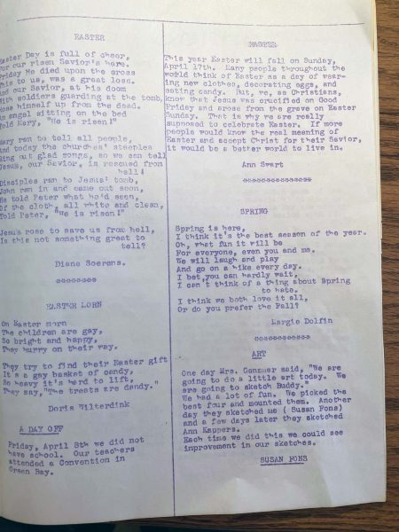
Here’s a poem I wrote about Easter (first article, left column). The poem shows that I can provide rhythm and rhyme, but it doesn’t look promising for my future as a poet.
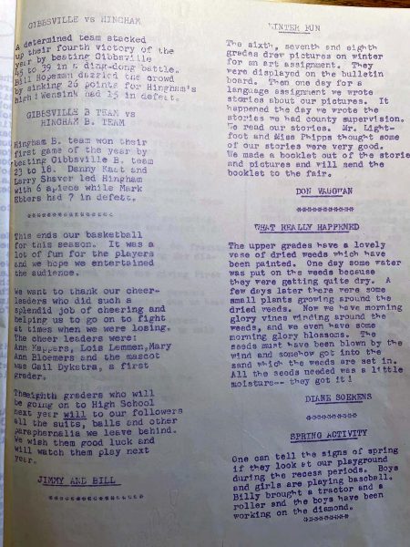
Just like the local newspapers our parents subscribed to, our school paper included a sports section. My brother, Denny, is reported as being a member of the basketball team (list of school team members, top of the left column). We used to play against a few other small rural schools. We even had cheerleaders in matching outfits that their mothers sewed. None of the schools had a gym, so basketball practice and games took place in the local village community halls. Every school had a baseball diamond, so those games were played at the schools.
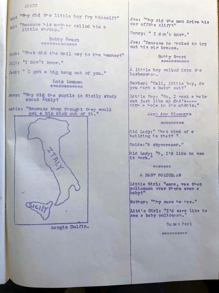
I love grade school jokes, and here’s a full page of them from the school paper. As our kids went through elementary school, Ted and I agreed that the fourth-grade jokes the kids told were the best, so maybe these were written by fourth-graders. Margie could draw very well, and that’s probably why she was drafted to draw the map of Italy and Sicily.
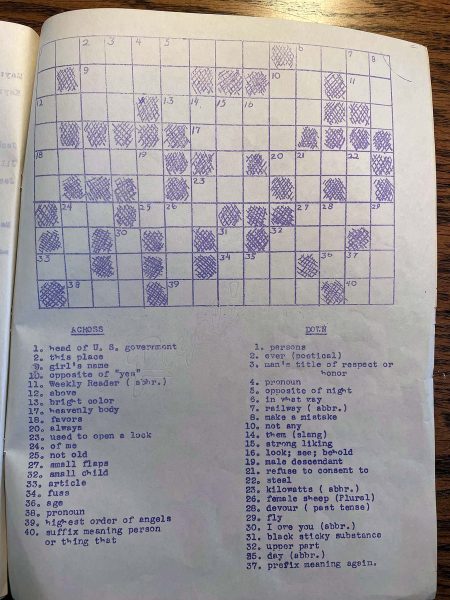
A newspaper wouldn’t be complete without a crossword puzzle. It’s not the New York Times’ crossword, but it’s fun to read and to solve the clues.
The newspaper pages I found on Facebook are apparently from a variety of editions of the school newspaper. Since every student wrote an article for the paper, I can’t imagine a single student contributing more than one article to any edition of the “news.” The former student who saved these pages might have been about my age, and saved the ones s/he was most interested in (i.e., those with articles by people close to her/him), which could explain why I found three articles I wrote, only two with Denny’s name, and only one each for Steve and Tom.
Theo, our grandson, recently had a high school assignment to interview someone who was alive in the 1950s. (I saw all the kids in his group contacting their grandparents for this one!) One of the questions he asked me was, “What would you do differently growing up?” My answer was, “Nothing. It was fun,” and that’s the truth.
While I was working, I regularly attended state and national conferences that always included a keynote speaker. Does anyone ever remember who the keynote speaker was or what s/he said? Probably not, unless it was something exceptionally good or exceptionally awful. I can think of examples of both, but even so, I only remember the tidbit of good or awful and nothing else of the speech.
One of my good tidbit memories is the speaker who began by asking audience members to raise a hand if they’ve been thanked too many times. No hands were raised. The speaker followed up by asking audience members to raise a hand if they are just one “thank you” away from too many times. Again, no hands were raised. A little bit farther into his presentation, the speaker said that it’s always good to say “thank you” and that, if you do, people always appreciate it. On the other hand, he continued, “If you write a thank note, they post it on the bulletin board.”
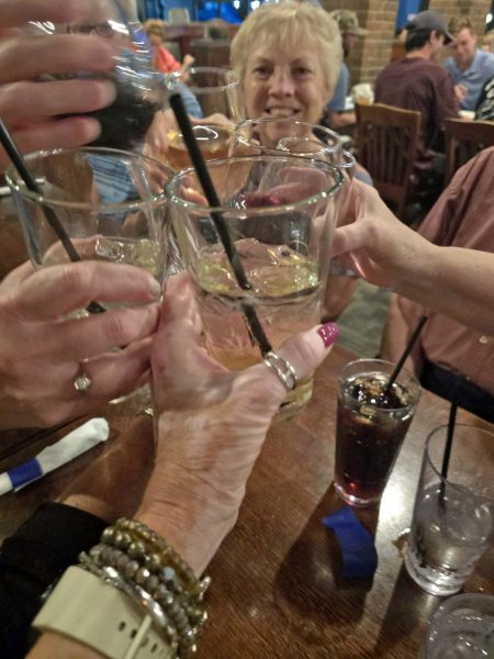
I received some bad news in February. Leila, one of the members of the Orchard Street Gang (OSG) died February 18. She is the first one of us to die, and it will be sad to meet as a group without her in the future.
I met four of the OSG members on my first day at college over 60 years ago (August 1965), and we have been BFFs ever since. Eileen’s dorm room was on one side of mine, and Leila and Barb had the room on the other side of mine. The Orchard Street house had room for six, so Eileen invited two of her friends from nursing school–Carol and Lin–to room with us as well. The six of us had so much fun living together! For all of us, it was our favorite year of college. Even better, we still have just as much fun when we’re together. Four of the OSG members were nursing students; Leila and I were the exceptions, with majors in education. Leila and I frequently rolled our eyes at each other when mealtime conversations turned into medical discussions, and we joked about it being our duty to come up with something to talk about besides blood and guts while we ate dinner together.
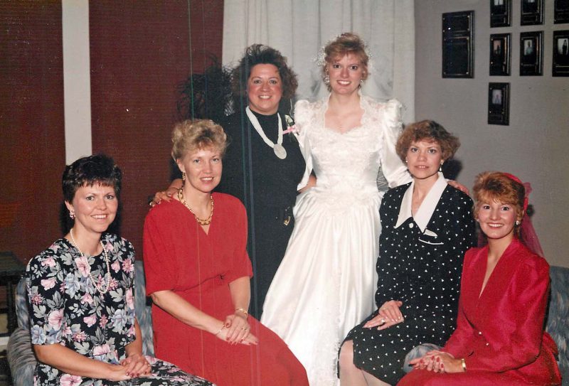
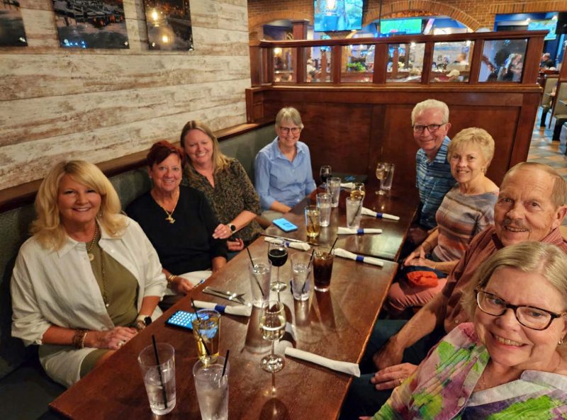
With the six of us living in five states (two live in the same state), it’s hard for all of us to get to every reunion. Here’s a photo of our 2018 reunion in Madison. (Back row L -> R: Eileen, me, Carol. Front row: Lin, Leila. Barb is missing.)
Here’s a screen shot of our 2020 Zoom reunion. (Top: Eileen, me. Bottom: Leila, Barb. Lin and Carol are missing.)
The six of us came up with such a good system for coordinating household responsibilities, that all of us applied the basics of the system in our own households. Breakfast, lunch, and weekend meals were on our own, but we ate weeknight dinners together. We had a rotating cooking schedule for dinner Monday through Thursday evenings, paired with a rotating schedule of two people nightly to do the dishes afterward. On the evening you cooked, you were never assigned to do the dishes. Saturdays were for group cleaning and grocery shopping. Each of us cleaned our own bedrooms, but we had another rotating schedule for cleaning the bathrooms and living areas of the house.
Each of us paid one-sixth of the $350/month rent and contributed $5 weekly to a household kitty. Yes, it was 1968-69, but I still find it hard to believe that $30/week paid for the telephone (the other utilities were included with the rent) and groceries for six people. We grocery shopped together from a list. Luckily, Lin had a car at school and we could drive to the grocery store and didn’t have to carry the bags home. If there was any money left afterward, we stopped at Dunkin’ Donuts on the way home for a treat. Imagine! A week’s worth of groceries for six people plus one-fourth of the monthly phone bill and we often had money left over from the $30 weekly kitty to buy donuts!
The University newspaper was called The Daily Cardinal. During Fall semester Orientation Week–a madhouse at a school with 35,000+ students–subscriptions to the Cardinal were sold at card tables on campus sidewalks. You wrote your name and address on a list at the table and gave your money to the table attendant who put it into a box. The crowds were huge and the process was very free-flowing and very chaotic. More than a half-century later, don’t tell the University that a week after Orientation Week, one of us (no names here) called the Cardinal office and said we’d ordered the Cardinal during Orientation Week, but it wasn’t being delivered. (This was actually very believable.) The result: we got a free newspaper subscription for the school year. When you’re short of money, you need to be clever about making it stretch.
The last time I saw Leila was in September 2024. She was diagnosed with Parkinson’s disease over 15 years ago and had recently moved to assisted living at that time. At our September 2025 reunion, Leila was hospitalized for a few days while the rest of us were in town, so she couldn’t join us.
One of my favorite memories of Leila was an evening when she came home from her waitressing job (all of us worked part-time) and was counting her tip money at the dining room table. One of the other women asked her how she could make that much money in tips in a single evening. Leila replied, “You compliment the women and flirt with the men.” That memory of Leila always makes me smile. She will be missed.
In January, we got a new washer and dryer. More than one person told me I’d hate it, because the new washers and dryers are awful compared to the old ones. I said I wouldn’t, because every consumer site I checked for reviews and ratings put Speed Queen in first place, noting that it comes with a 5-year warranty and has a life expectancy of 25 years. Why? Because Speed Queen makes a mechanical model, as opposed to a hi-tech model. I have dials to turn, not electronic panels with a zillion settings to choose from. Fewer parts, fewer things that break.
Unfortunately, my dryer did not do a good job of drying my clothes, and everything came out damp. Only the timed settings worked, so I couldn’t use permanent press, etc. Before a serviceman came to the house to diagnose the problem, we were advised to have our dryer vent cleaned out. If we didn’t, the first thing he’d tell us to do would be to have the dryer vent cleaned professionally, and he’d charge $115 for the service call to say that.
Although Ted regularly uses our leaf blower to blow out the vent from the laundry room to the outside, it’s been a number of years since we’ve had it professionally cleaned, so we made an appointment for that service. The serviceman said he wasn’t removing much lint compared to what he usually does, but he did hit a blockage at one point. This might be better than most of his customers, but I don’t think having the vent professionally cleaned was a bad idea even though, as it turned out, that wasn’t the problem with the dryer.
With that completed, the dryer warranty serviceman came to the house. Everything he checked seemed to be working properly. He asked me for a damp dishcloth that he could put into the dryer to test it and then diagnosed the problem as a faulty thermostat. How could he tell? When he started the dryer, it indicated that it was heating. He told me the heat cycle turns on and off to avoid overheating, but mine didn’t turn back on. He pointed out that there’s a barely audible click sound each time the heat cycle restarts and my dryer wasn’t making that sound.
He ordered a new thermostat, came back and installed it, and all is well. I did laundry over the weekend and all my clothes dried. Oh, happy day!
I love to see all the blooming flowers and trees in the spring. Unfortunately, we have two “stupid” trees–our two early spring magnolias. Every year, they are as eager for spring as I am, so as soon as we have a few warm days, they open their buds to show off how pretty they look.
Except for one year in the 15 years we’ve had these trees, there has always been a severe frost while these trees are in bloom and, the next day, all the blossoms are wilted and brown. This year, they were happily blooming and, 3 or 4 days after they opened, the overnight temperature dropped to the low 20s and the daytime high afterward was in the upper 20s. Naturally, all the blossoms turned brown. Again.
Our daffodils, on the other hand, must be among the hardiest bulbs in the universe! In Fall 2024, we had warm temperatures through most of November. When the first snow fell, some outdoor growth was still green. Enjoying the warm November, our daffodils started growing and were about 4 inches tall when the first serious frost hit and winter arrived. I was disappointed, because I assumed that, since they had already sprouted, we could forget about seeing daffodils blooming in our yard in Spring 2024. Unbelievably, the 4 inches they grew remained green and above ground all winter and–lo! and behold!–they burst into full bloom in the spring.
This year, they were happily blooming again when we had that killing frost (above). When I looked out the window the next morning, every single daffodil stem had fallen and was lying on the ground. I was surprised to see that the blooms did not look wilted or brown. I was even more surprised when the temperatures warmed up (we topped 90 degrees 3 days after the frost) and the daffodil stems started rising. Only a few lacked the strength to stand, but they all continued to bloom brightly.
Years ago, we had some crocuses at the front door. I loved them, because they were the first announcement of spring, blooming in February, often while there was still snow on the ground. Last fall, Ted planted some more crocuses for me. They weren’t eager to come out into the cold to start growing, so the daffodils bloomed before the crocuses. We had a few blooms, and I thoroughly enjoyed them. I hope we have more next year.
Every spring, when the forced bulbs appear in the grocery stores, Ted buys me a pot of spring flowers. This year, it was red/white tulips.
I’ve never seen tulips with an edge like this on the petals.
Flowering spring bulbs are one of my favorite treats from Ted. You can see why I love that guy so much–he plants and cares for all these spring flowers to bring joy to our yard during my favorite season of the year.
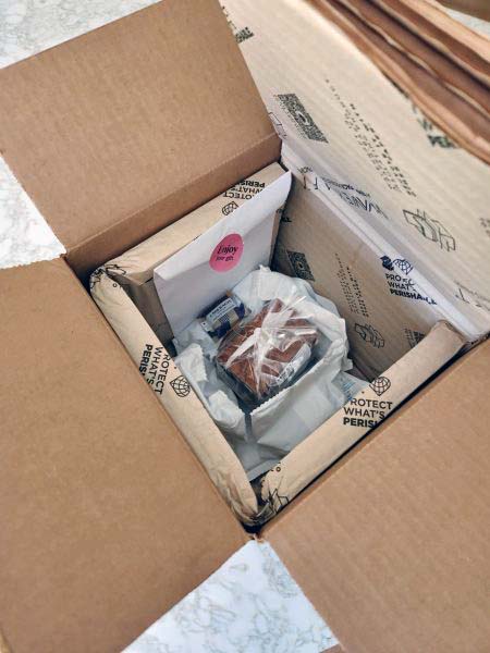
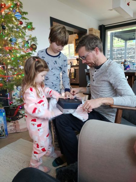
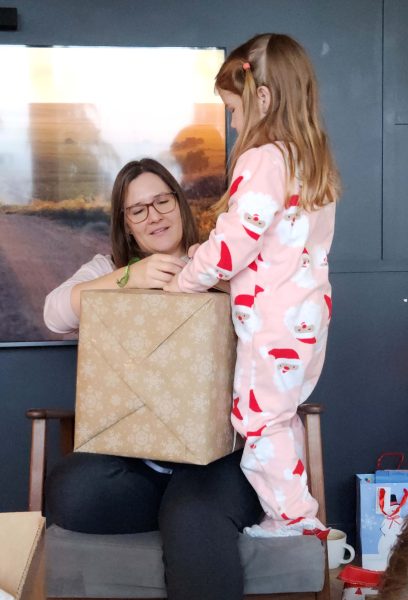
This afternoon, Ted handed me a wrapped gift. It’s not my birthday yet, so I asked him why I was getting a gift. His answer: To celebrate the great news we received on March 6–and also maybe an early birthday gift. I couldn’t imagine what it would be, and he said he didn’t think I’d ever guess what it was. He was right.
After I opened it, Ted showed me how it had arrived. The lumpy white things are cooling packs; the inner lining of the box is insulation to keep the bag in the center from melting. Ted said it was still cool when it arrived today.
I was shocked and might have gasped when I saw what it was: Läderach candy from Switzerland! Later, Ted showed me the enclosure that listed all the places it’s for sale in the U.S. The closest to us is Chicago.
We bought some of this candy when we were in Geneva on our 50th anniversary trip. If it’s not the best chocolate in the world, I can’t imagine how any other chocolate could taste better.
Ted was right. I never would have guessed what was in the box. We occasionally still mention how good this candy was, and it’s nice to know that we can get more of it closer to home. Ted chose the perfect gift to celebrate March 6.
P.S. Ted said it’s all for me, but I couldn’t enjoy it without giving him half. It’s a taste experience that’s much better if it’s shared.
While I attended grad school, I worked full-time, had 0-3 children living at home (depending on the year), and carried 6 graduate credits. That meant I had 6 hours of class plus a 30-minute drive back and forth to the campus every week after my workday, and my study time at home was at least 20 hours per week. The result: I pretty much gave up exercising because I didn’t have time for it. I achieved three post-graduate degrees–two master’s degrees and a doctorate–and graduated for the last time in December 2005. I love to exercise and I missed doing it, so my New Year’s resolution for 2006 was to get back to regular exercising.
One of the employee benefits at the community college where I worked was free use of the Fitness Center and free classes. It was winter, so I started by going to the Fitness Center at the end of my workday and doing “the circuit”–a series of equipment arranged to work out at one piece of equipment, then move to the next one through the circuit, gradually warming up and working every part of your body. One day, while I was doing the circuit, a Fitness Center employee invited me to do Pilates with her, so I did and I loved it. Eventually, Theo (the employee) had a group of 5 people informally doing Pilates with her. She decided to become a certified Pilates teacher so she could be paid to teach Pilates classes and after that, we were able to exercise in a dedicated exercise classroom, complete with mirrors to monitor our form, rather than in an open corner of the Fitness Center.
Ted and I were getting older by then (shocking!) and we were beginning to feel a little stiff when we got out of bed in the morning. I’d been doing some stretches at home to loosen up, but Pilates was even better, so I invited Ted to join the class too. He and I are now in our 21st year of attending twice-weekly Pilates classes taught by Theo. In fact, we’re her longest-term students. The result: we are no longer stiff when we get out of bed in the morning, and we’re both far more flexible than friends and neighbors our age. A few days ago, Ted sent me this screenshot.
The woman on the T-shirt is doing Pilates with a machine called a reformer. Ted and I do classical Pilates, where our body does the work. Our only equipment is a stretch strap, a ring, and some free weights. Regardless of the version of Pilates, the slogan on the T-shirt is so true, that I asked Ted to video me doing some of of the Pilates moves we regularly do. At every class, we stretch for about 15 minutes to warm up and then we do the “hundreds.” We hold this position and repeat the arm motion 100 times in unison as a class.
We don’t do traditional sit-ups; we do three different styles of roll-ups, one right after another, with 5 reps of each style, totaling 15 roll-ups. This is one of them. If you want to try it, keep your hands on your forehead and touch your head to your knees, then slowly roll back and lie down. Slow and controlled is the Pilates motto. We don’t use upward thrust to overcome gravity, nor do we do quick drops to take advantage of gravity. It’s all about our very own core strength.
This is a rollover. We do a variety of rollover styles. Theo saves this until the new students in the class are strong enough to do it without injuring their backs, and then she has us do 3 different styles with 3 reps of each style for a total of 9 rollups. Again, slow and controlled.
When we finish our hour-long sessions, we stretch. I don’t know if this stretch has a name, but we put our hands behind our ankles and pull our foreheads to our knees to loosen our backs and the muscles we’ve worked in our legs.
Yessireebob! The best of us still do Pilates in our 70s–and we love how strong and flexible we are.
Yo-Yo Ma was a guest on the Steven Colbert Late Night Show a few weeks ago. I expected a mostly-serious world-class professional musician and a so-so interview, but he was surprisingly entertaining and funny. At one point during the interview, Ted and I burst out laughing.
Stephen: Is music funny?
Yo-Yo Ma. Of course. Every time I make a mistake, it’s funny.
Stephen: Are there any composers who are funny?
Yo-Yo Ma: Oh, yes. Haydn is funny. And Seiken is funny. Haydn and Seiken.
(Insert laughter here.)
I had to look up Seiken, because I’ve never heard of him. In case you’re wondering, Seiken is the artist name of Sergio Pérez Sànchez, a Madrid-based music producer and DJ. One website described him as a “restless, eclectic and multifaceted electronic music producer” so, yes, maybe funny.
After the interview, Yo-Yo Ma performed a medley of Bach’s Prelude from the 1st Cello Suite and his (Yo-Yo Ma’s) adaptation of “Over the Rainbow.” We didn’t hear any mistakes, so not funny–just amazing and beautiful to hear.
I enjoy snowblowing. I usually use the snowblower to clear the driveway and the patio. Sometimes, I do the sidewalks too, especially if Ted is going to clear a neighbor’s driveway when I finish–then it’s his turn to play with our winter toy.
This year, we had a 2-day snowstorm that dropped 6 inches of snow the first day, followed by 9 more inches of snow the following day. The elderly lady, whose driveway Ted used to clear, has moved away, and the other widow neighbor hired a person to clear her driveway, so Ted played with our snowblower for the first 6 inches. I’m glad he did because, after the 9 inches fell, the snowbanks Ted created along the edges were just visible enough for me to see where I should go on the second day instead of needing to find where the concrete ended. He also cleared the sidewalks while I worked on the driveway and the patio.
The weather was very dry and very cold, so this was a light snow. You can tell by how high the snowblower is blowing it. “Light” is a relative term, however. Even if it’s light snow, 15 inches of it is heavy.
In the photo below, you can see the blown snow accumulating against the hot tub. Yes, even if it’s not clear in the pictures, I’m smart enough to blow the snow to the side, not ahead of myself.
We are a rarity in our neighborhood. Our snowblower can handle a foot of snow–usually enough in our area–but if heavy snow is expected, we take advantage of any breaks in the snowfall to clear the accumulated snow and then we clear it again after more snow falls. We think of this as a great way to get outside and to play in the snow! Our neighbors who usually wait for the storm to pass, had a hard time shoveling 15 inches of snow out of their double-wide driveways. Even those with snowblowers had to resort to using a shovel. Several of our neighbors hired a man with a small tractor and a scoop to clear their driveways.
The scoop did the job for our neighbors in far less time than Ted and I spent with our snowblower, but Ted and I had a lot more fun than those who watched the tractor guy work for a short while. When we finished, we felt invigorated and happy. Let’s hear it for exercise and endorphins!
Every now and then, I find a pile of old photos–sometimes in a box I’m cleaning out, sometimes in an old computer file. I recently found these and enjoyed the memories.
While I was working at St. Charles Community College, I was active in the state organization, MAACCE (Missouri Association for Adult, Continuing, and Community Education), and attended the state conferences every year. I found some of those conference photos.
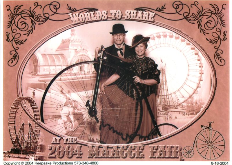
In 2004, Ted joined me at the conference. He amused himself during the meetings and workshops, then met me for dinner and the evening activities. The 2004 conference theme was Worlds to Share, celebrating the 100th anniversary of the 1904 St. Louis World’s Fair. Ted and I had a period picture taken.
#In 2005, I was elected MAACCE president-elect, which was essentially vice president. That meant it was my job to plan and to preside over the conference. Of course, I had lots of committees filled with volunteers to help, but it meant a lot of extra after-work hours for me to coordinate all those volunteers and the plans they were making, plus all the venue details (meeting, vendor, and entertainment spaces, rooms, food, session schedules, etc.). The conference was the end of my president-elect term and the point at which I became president of MAACCE. The board voted to have a Mardi Gras theme for the 2005 conference, so the newly elected president-elect and I presided as the King and Queen of Mardi Gras. We had a ride around the ballroom in a decorated vehicle, waving our scepters to the crowd.
At that same conference, my friend, Liz, offered to be a fortune teller as part of the entertainment for one evening. Here she is, telling my fortune. That was quite the Mardi Gras queen oufit I wore. It even had a hoop skirt.
Here I am at the 2010 MAACCE conference enjoying myself with no responsibilities except for the two session presentations I gave.
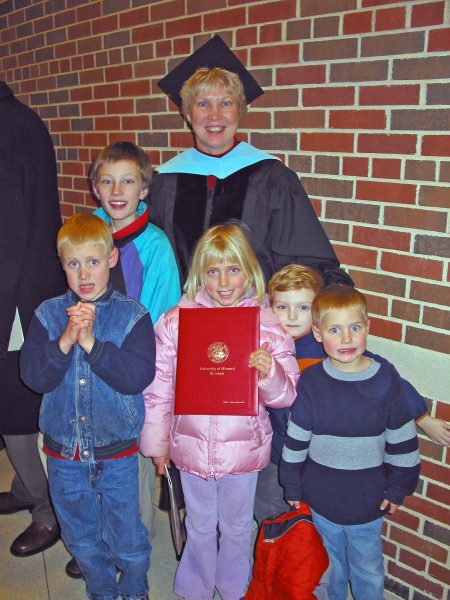
Another photo I found was from December 2005, when I received my doctoral degree. My grandchildren were at the ceremony to celebrate with me, although Zack looks a bit wary.
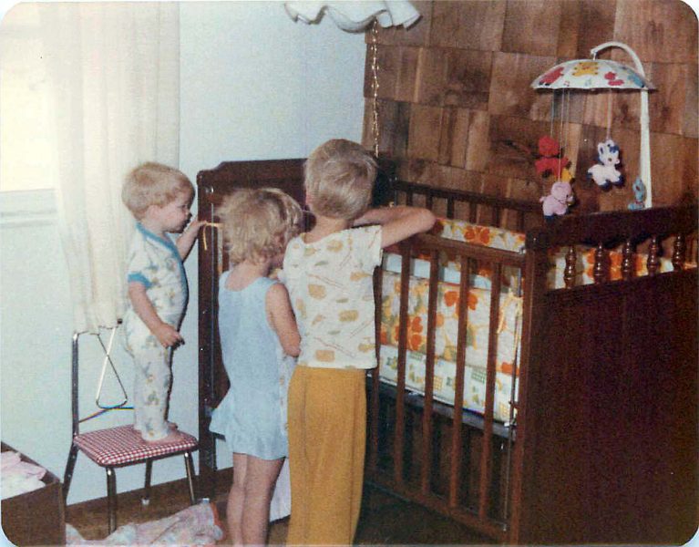
Quite a few of the photos I found by accident were of our family. When Kari was born, siblings were not yet allowed to meet the new baby in the hospital. In the photo below, you’ll see what I saw the morning after we brought Kari home from the hospital. She was the new attraction in the family! I love two-year-old Tommy on the chair so he can see into the crib.
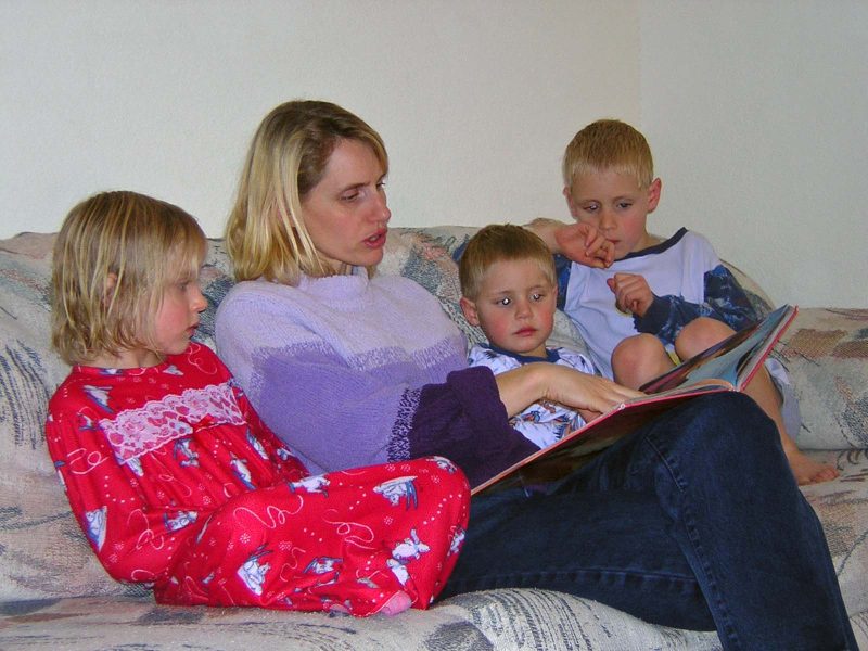
I found some photos of Jeff’s family that made me smile. Here’s La, reading a bedtime story to Kyra, Zack, and Alex.
When we visited Jeff’s family for Alex’s baptism, the bishop took a picture of Alex with his grandparents and siblings after the service.
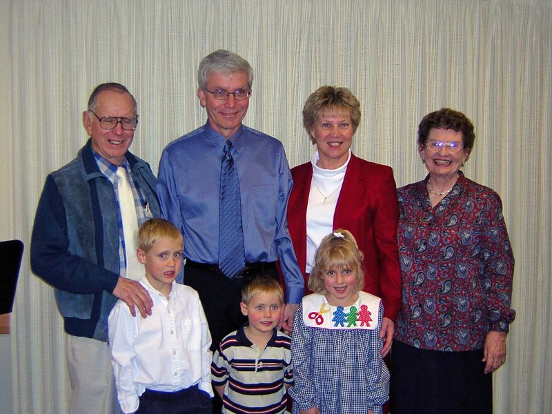
Later, at the house, someone (probably Jeff) took a picture of the kids with their grandparents. That was a happy time, as you can see by all the smiles.
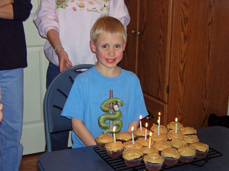
We also celebrated Alex’s eighth birthday during that visit. Here he is with his chocolate cupcakes and caramel frosting–a family favorite.
There was a surprise batch of photos of Kari’s family too. The first one is so cute–Dean mimicking Baby Sky.
Here’s our first photo of newborn Dylan. Notice that his big brother, Sky, put some toys for him within easy reach on Grandpa’s leg.
Moving on, we have party pictures taken at Dylan’s third birthday party. Dad appeared in costume.
Apparently, Dylan recognized him because he doesn’t look the least bit frightened by the red-faced man.
Annette enjoyed the party so much, she needed a little nap to perk herself up for the next part of the fun.
In August 2005, Ted and I took a trip to Niagara Falls.
From there, we drove west and took the car ferry from Ludington, MI to Manitowoc, WI. I don’t remember how long it took the ferry to cross Lake Michigan, but I remember we had to be at the dock to leave at 4:30 a.m. This is a picture taken in Ludington, looking west across Lake Michigan.
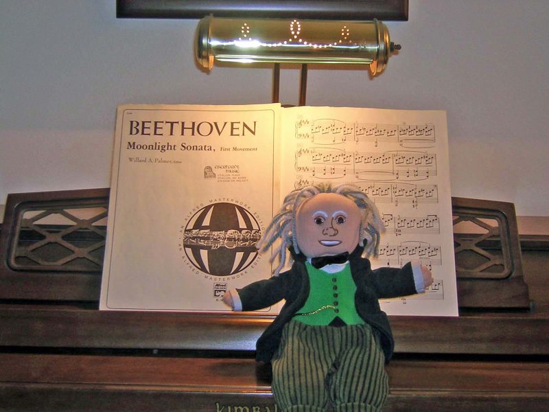
Here are some fun photos. I haven’t seen them for years, but I laughed again when I saw them. Kathy and I found this Beethoven figure when we spent a day in Columbia, MO in 2005. We knew I’d be graduating in December 2005 (above photo) and that, because all of our family was coming for the ceremony, Thom would be there for Christmas. Thom loves Beethoven, and it seemed like the perfect gift for him. After all the gifts were opened and there was a lull in the activity, Kathy and I set up these poses for Beethoven.
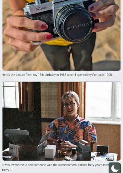
Last, but not least, I saw a photo in Jeff’s blog that requires a minor correction. He did not receive this camera for his 16th birthday; it was a gift on his confirmation, when he was 14. The camera is even older than he thinks it is.
I was reading one of the books I bought at the library book fair last August and found these tucked between the pages. What a sweet little girl the previous adult reader has.
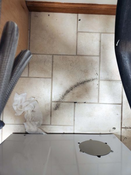
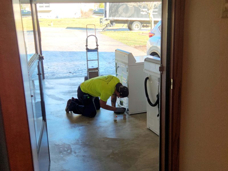
While I was doing laundry before Ted and I left home to spend Christmas with Thom’s family, I noticed water on the floor at one corner of my washer. It didn’t look like a “gusher” leak, and I only had two more loads to wash, so I put a towel on the floor to absorb the leaking water and finished the job. Afterward, Ted and I pulled the washer away from the wall to see what might be leaking. We saw this black circle on the floor. It looked like something was spinning (probably the tub) and threw out some black stuff. It wasn’t oily, and it wiped up easily, but that didn’t seem like a good sign, given that my washer and dryer were 30 years old–almost to the day! (Ted’s and my first washer and dryer–when we bought our first house–were Lady Kenmore appliances from Sears and lasted 22 years.)
I called Henry, my go-to appliance repairman (who we hardly ever need, because we buy brands he recommends), to ask if he thought the black stuff and the leak were fixable. He offered to take a look, but he thought it was probably something coming from the motor and being blown around.
For years, my washer has been missing a solenoid that shuts off the water supply when the washer is not in use. Without the solenoid, there is a constant slow drip into the washer tub. I solve the problem by flipping the handle on the water supply shut-off valve behind the top of the washer to “on” to do laundry and to “off” when I’m finished. The reason the solenoid is missing is that Henry couldn’t find the right part to replace it because solenoids now have a different number contact points than our old one. What are the odds that, 7-10 years after the solenoid part became obsolete, Henry will be able to find the parts he needs to fix the motor? Answer: Low. What are the odds, if he does find the parts, that it will cost less than $500 to repair a 30-year-old washer with a (possibly) failing motor that cost $630 new? Answer: Low. What are the odds that this is only the first in a series of failures for such an old appliance? Answer: High. Ted and I decided it’s probably smarter to buy a new washer and dryer.
Henry has constantly marveled at my old washer. One time, his son came to our house with him and asked, “Is this that old Maytag you tell me about?!” I only remember two repairs on the washer–a new hose, and a leak near the tub–and two repairs on the dryer–2 replacement thermostats–in the 30 years we’ve had these appliances. When we bought them, Maytag advertised that the Maytag repairman was “the loneliest man in town.” No one ever called him. I remember ads like the picture below (I found it online) where he sat at his desk, waiting for the phone to ring. In one ad, his dog led him to an empty dog food bowl and the repairman said, “Finally! Something I can fix!”
When we bought the washer and dryer, the store had a Maytag washer running constantly. Customers could enter a lottery in which they would win a new Maytag washer if they accurately guessed when it would stop running. Ted and I didn’t enter the lottery because we had just purchased a new Maytag washer and dryer. I don’t know how long that washer ran, but the store is out of business and my washer lasted 30 years.
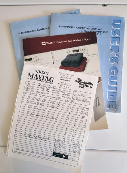
We still have all the user’s manuals and the receipt from the washer and dryer. Anyone who has shopped recently knows you can no longer buy a washer and a dryer for a total of $1,240. Note the date on the receipt: 12-12-95. I noticed the leak and the black stuff on 12-19-2025.
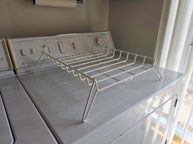
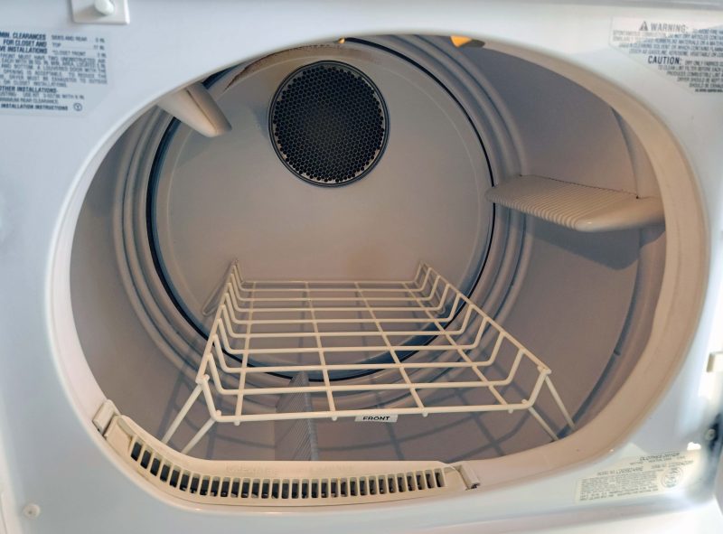
This rack was one of my favorite features on my dryer.
The rack fit inside the dryer without touching the drum, so I could set things on it to dry without tumbling. I used it for garments that need to be laid flat to dry (e.g., sweaters) and for drying athletic shoes. (Yes, I’ve thrown athletic shoes in the washer for as long as I can remember. I laugh when I see articles about how to keep your athletic shoes from smelling bad. Wash them!)
For years–probably since front-loading home washers became popular–I’ve heard nothing but bad things about new appliances from friends, family, and Henry. Henry told me he regularly fixes new appliances that are still under warranty! For a while, it was hard to even find a top-loading washer, and I hoped that my washer would last until people figured out that front-loading is a pain, and until stores included more top-loading machines in their stock. With a front-loading washer, you can’t add an additional item to the load; you can’t remove an item you put in by mistake; and, unless you leave the door ajar to dry out the interior, it stinks.
Before buying a new washer and dryer, I did some online research, hoping to find one that would last more than five years. I checked at least five consumer sites for “best washer and dryer,” and every single one had Speed Queen as the top choice, with information indicating it is expected to last 25 years. It’s not the brand I would have guessed, but when I looked into why Speed Queen lasted so long compared to other washers/dryers, I learned that it’s because they are built for commercial use and do not use electronic panels for cycle selections–just simple knobs and dials. As a result, the mechanisms are simple and have few problems. Ok, Speed Queen it is!
The next problem was finding a retailer that carried Speed Queen. I found one–one!–that had a store within five miles of us: the Slyman Brothers. Anyone who’s lived in the St. Louis metro area during the last 50 years, like Ted and I have, will recognize the Slyman Brothers as the guys who sit on top of the Arch in their ads. Yes, those goofs! I never took them seriously because of the dopey ads, but they are apparently a very reliable–as well as memorable!–dealer, and they were pleasant to work with. Ted and I went to Slyman Brothers when we returned from our Christmas visit with Thom’s family, and they delivered the new appliances two days later.
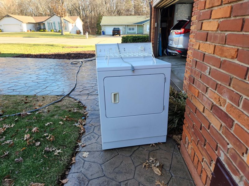
Here goes my 30-year-old washer. It made me a little bit sad, like watching an old (inanimate) friend going to its end-of-life. It was a trusty machine, and it worked hard and well for me. Thank you, Maytag washer.
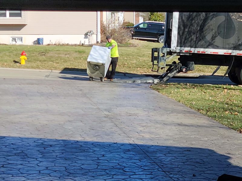
Henry repairs appliances, and he also sells used (repaired) appliances in his store. When I told him we were going to buy a new washer and dryer, he said he’d love to get his hands on my dryer, so we asked the delivery guys to leave it on the sidewalk and to deduct the dryer disposal fee from our bill. Henry’s son picked it up within an hour.
Here’s one of the delivery guys connecting whatever needs to be connected on the new appliances.
Here, they’re connecting the water line to the washer.
This is my last photo of our old Maytag washer and dryer.
Here are my third (in 52 years) brand new washer and dryer. Except for the updated appearance of the panels, they look and operate almost exactly like my old ones. Will it be 22-30 more years before I need to replace these?
Of course, there are some things I’ll miss on my old washer and dryer. For example, the drying rack (above) and also the dials with timers. When I set the dryer timer on my old models, the dial would turn and I would know exactly where it was in the cycle. The new ones don’t turn during the cycle. I set them and, unless I watch the clock, I have no idea how close the load is to being dry. On the other hand, there are things I like on the new washer and dryer, especially the larger tub/drum, so our flannel bedsheets fit better.
The fact that our washer and dryer lasted 30 years is probably more surprising than the fact that the washer failed after 30 years. (The dryer still works perfectly.) Puzzling over this, Ted and I reached a possible cause. When we updated our laundry room cabinets, the carpenters took our washer and dryer out to the garage to make room for them to install the new cabinets. Then, of course, they moved them back into the laundry room. Ted and I suspect that the two moves jiggled an old, fragile part loose on the washer. (Not the carpenters’ fault.) Maybe if we’d left the laundry room with its dated appearance, the washer would still be washing clothes for us, and we’d still have the dryer too. Oh well, they had a good run at an average cost of $41.00/year.
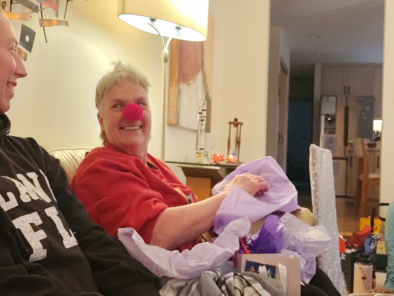
Although we usually take our Christmas decorations down on New Year’s Day, we extended our holiday decoration season a few days to celebrate Christmas and New Year’s with our girls’ families.
Annette’s birthday was in September and Ted’s birthday was in December. Due to unforeseen circumstances, we haven’t all been together since September, so we started the gift exchange with the celebrants opening their belated birthday gifts. Here’s Annette, opening one of hers.
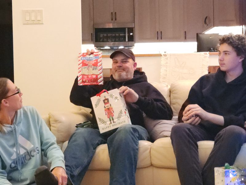
Dean and I both like the Ghiradelli Christmas peppermint candies, so we give each other a bag of them to enjoy. It’s a predictable gift, but ooh, yummy!
Kathy received a highly recommended book from Kari.
Ted didn’t read the gift tag, so he opened a game that Dean gave to me. (I’ll share it with Ted.) After everyone went home, I checked out the rules, and it looks like it’s easy to play. I think we’ll have fun trying it out the next time we get together.
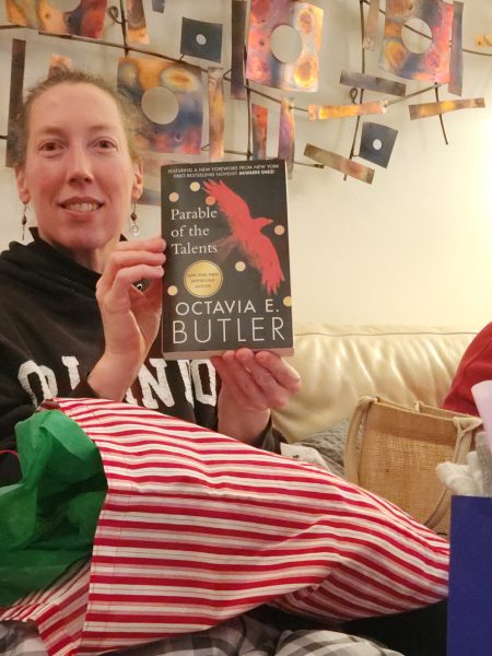
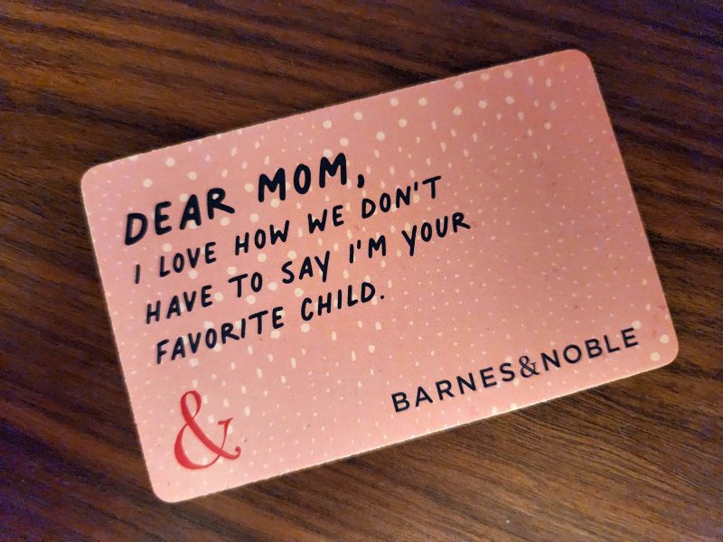
I unwrapped another recommended book from Kari and Dean, a Barnes & Noble gift card, and a silky red scarf from Kathy and Annette.
We all laughed out loud when I showed the group this gift card from Kari and Dean. Wow! I received three B & N gift cards this Christmas! I’m looking forward to an afternoon of browsing at the bookstore!
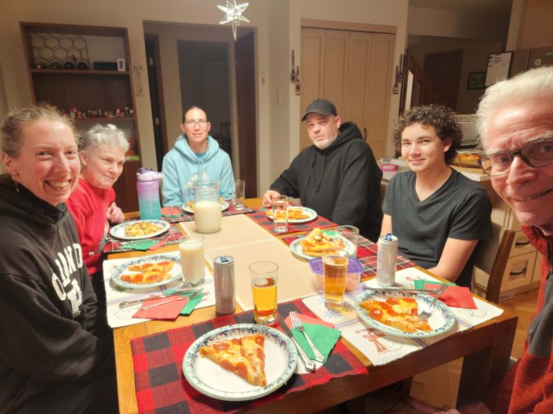
We kept dinner simple. Theo works at a locally owned pizza restaurant, so he helped Kari and me prepare pizzas for dinner. We all like pizza, and it was an easy meal, with Christmas candy and cookies for snacks and dessert.
Here’s our dinner group, enjoying the pizzas.
While we were visiting and catching up with each other, we learned that Annette has never seen When Harry Met Sally. We all wanted to watch it, so Ted booted up our DVD, and we enjoyed margaritas from Kathy and Annette while we watched the movie. Now Annette knows why everyone loves the line, “I’ll have what she’s having.”
The following afternoon, Kathy and Annette went back home, and Kari’s family was either working or involved with other activities. We’re looking forward to our next gathering–probably to celebrate the five spring birthdays in our group.
Jeff and La were here in early November, we spent Christmas with Thom’s family, and our two girls’ families were here for New Year’s Eve and Day. We saw all of our children within seven weeks–a rarity. Now the kids are back in their own homes, and Ted and I have warm memories of this year’s holiday season.
Note: The little Lego snowman on the table was my gift from Thom this year for our traditional Christmas Lego exchange.
Wenatchee is roughly three hours from Sea-Tac airport. Ted and I had a nonstop flight from STL to Sea-Tac for our Christmas visit with Thom’s family. (Unfortunately, we had to get up at 4:15 a.m. for the flight. 🙁 ) From the airport, we took the Wenatchee Valley Shuttle to Wenatchee. With the early four-hour flight, three hours between our arrival at Sea-Tac and our departing shuttle, then a three-hour shuttle ride, it was a long travel day. It was definitely worth it to spend Christmas with Thom, Katie, Sefton, and Hadley but, still, a long day.
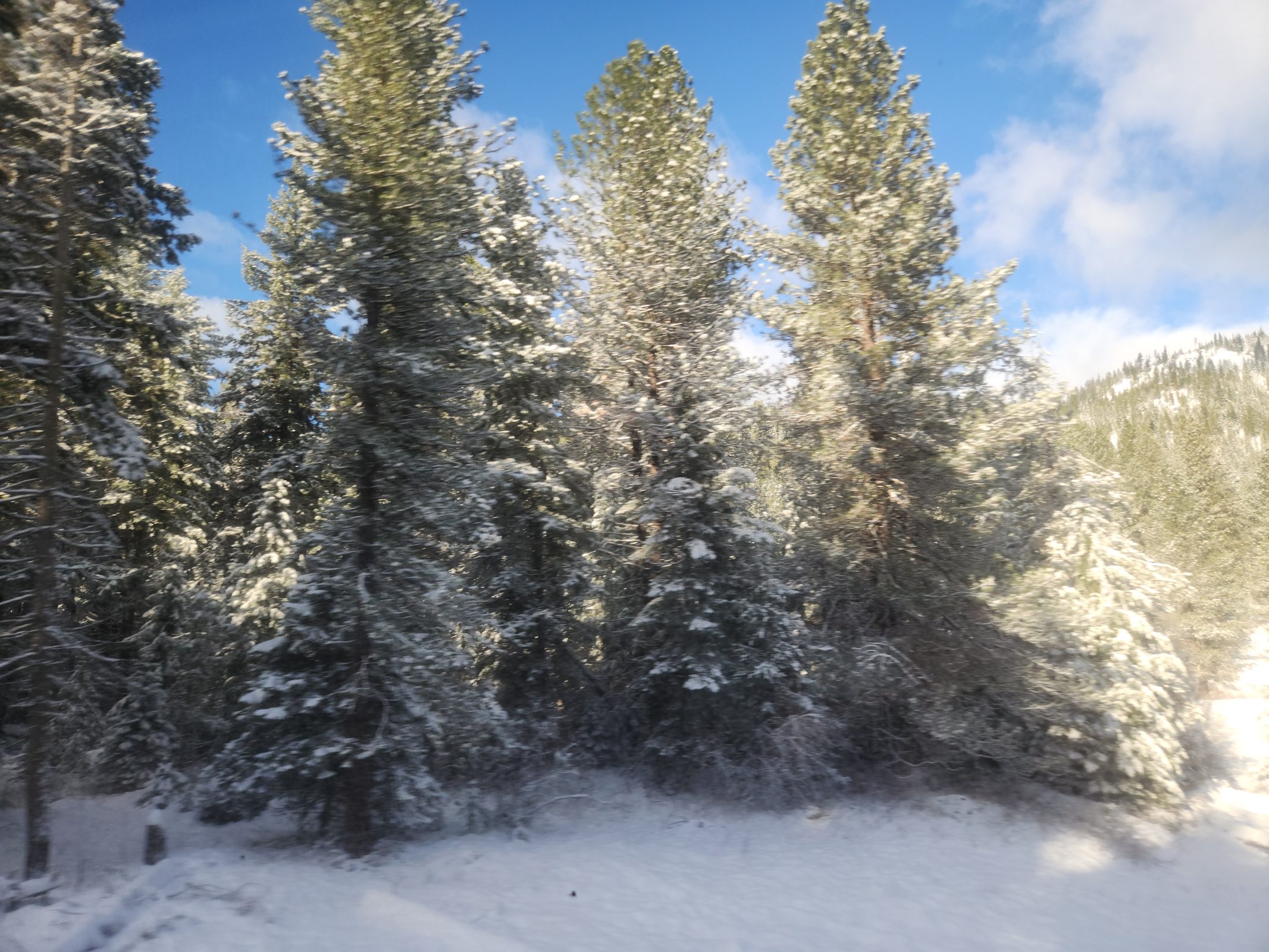
We did the same thing in reverse on our way back, with a far more scenic shuttle ride because it snowed in the mountains overnight. We experienced some of that snow at our Mission Ridge Ski Resort dinner the previous night, but on a clear, sunny day, the snow was sparkling and gorgeous! The higher we went over the pass in the Cascade Mountains, the deeper the snow became. At the top, it was at least a foot deep. Every view seemed more beautiful than the last.
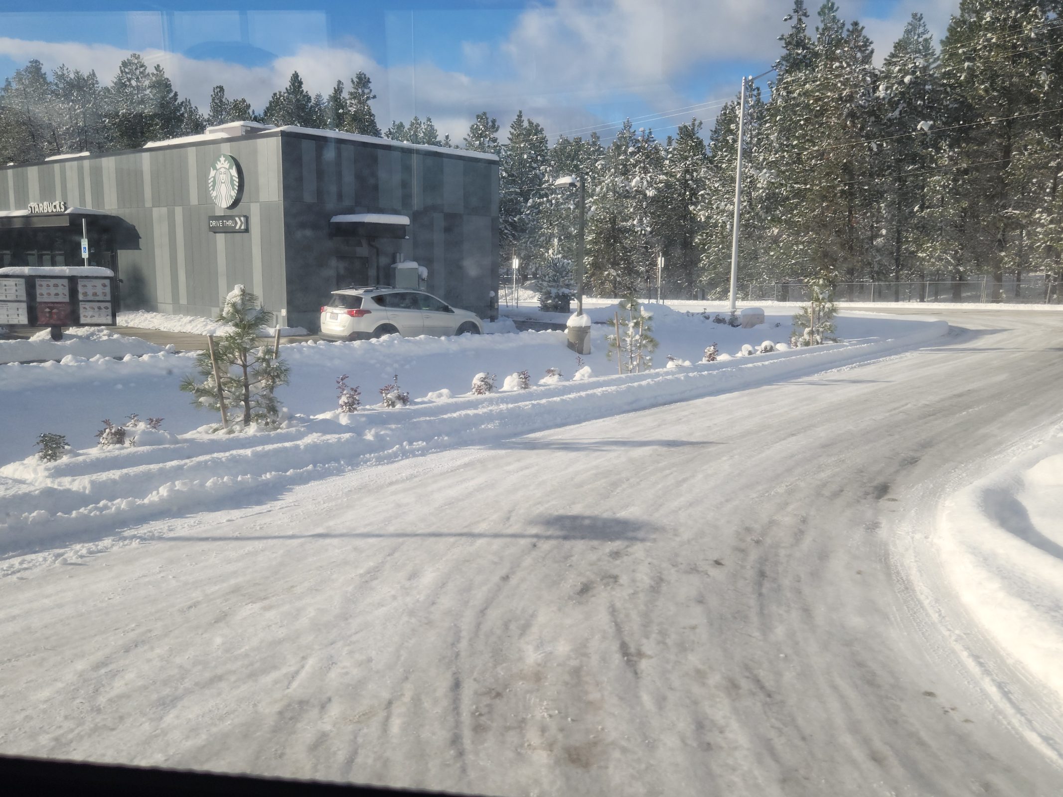
The shuttle makes a rest stop in Cle Elum. You can see in my photo below that the snow was deep enough to require plowing the roads. Ted and I had brought a sack lunch to eat on the shuttle drive. At the rest stop, Ted returned to the shuttle with a surprise dessert: A Milky Way Midnight candy bar for each of us. I don’t remember when I last had a candy bar, but Ted knows that Milky Way Midnight is my favorite. It was delicious!
Note: The same candy bar was called “Forever Yours” when I was a child, and it was my favorite then, too. Mars stopped making “Forever Yours” in 1979 and didn’t bring out the “Milky Way Midnight” until 1989. I missed it for every one of those 10 years!
After the rest stop, the beautiful shuttle ride continued.
As the shuttle descended to Seattle at sea level, the snow decreased, then disappeared to be replaced by a gloomy, cloudy city. After another layover at Sea-Tac, we had a non-stop flight home and parked in our garage around 1:00 a.m. Another long travel day, but a wonderful holiday spent with the Wenatchee branch of our family.
Naturally, we’ve seen Thom, Katie, Sefton, and Hadley over the years, but we usually visit back and forth during nice weather so that we can enjoy outdoor activities. Their family spent Christmas 2022 at our house, but we haven’t spent Christmas at Thom’s house since 2009–before he was married and had Sefton and Hadley! Ted and I decided to spend Christmas 2025 in Wenatchee.
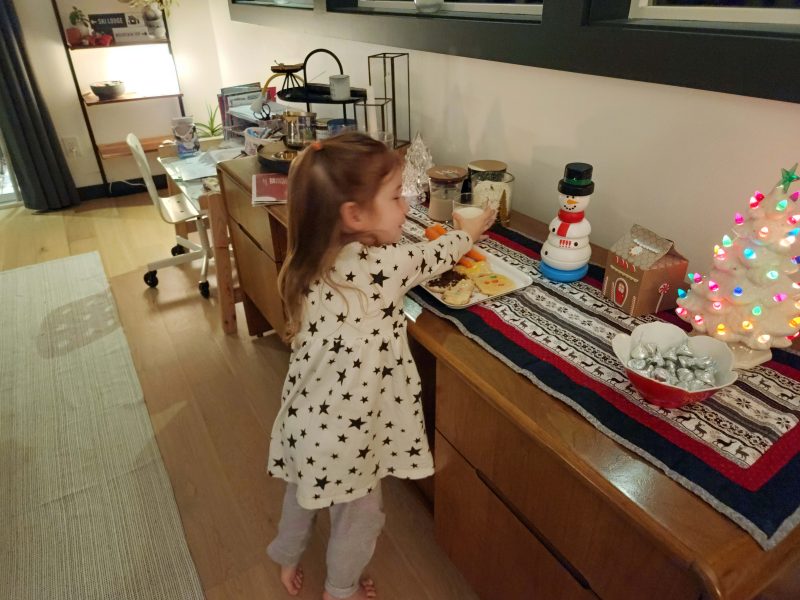
Hadley is such a sweetheart! She has all the exuberance of a four-year-old and wanted to share all of her age-appropriate activities with Grandma and Grandpa. We attended parties for her stuffies in her room, and here’s a picture of me coloring unicorns (her favorites) with her.
The weather was cold (duh! winter!), but sunny and calm, so on Christmas Eve afternoon, we took a walk through downtown Wenatchee. We admired the holiday decorations and went into a few stores to browse. Thom recently accepted a different job, so he gave us a tour of his “new” downtown office suite. Thom didn’t have his office key with him, so I won’t tell you how we got inside, except to say, “Thanks, Katie–you had the skills we needed!”
Here’s Thom’s personal office and workstation, located on the right side of the hallway in the above photo.
Trust Thom to have a camera nearby and trust him to have an–even cooler–Lego camera on his desk.
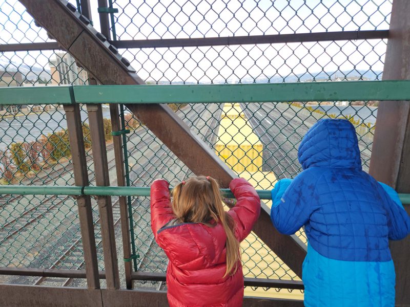
We decided to walk from downtown to a nearby city park and had to cross a bridge over the train tracks. A train was approaching, so Sefton and Hadley were thrilled to have the train (yellow boxcars) pass beneath them.
Here’s Hadley playing at the park.
Ted took a group photo of us. Note that I’m all bundled up in my 800-fill down jacket, Katie is wearing her 900-fill down jacket, and Thom is wearing his down jacket zipped to the neck. In the same weather, Hadley’s jacket is unzipped, and Sefton was too warm to even wear his! (Ted had his down-filled jacket on too. Zipped.) What keeps kids so warm when we adults need to bundle up??
When we got back home, it was snack time for the kids.
It was Christmas Eve, so before bedtime, Hadley put out Santa’s food–milk and cookies for Santa and carrots for his reindeer.
Both kids stayed up later than usual and we watched Elf together.
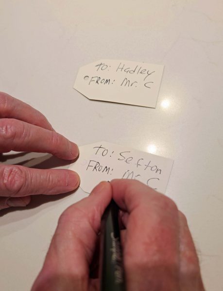
After the kids went to bed, we needed someone whose handwriting they wouldn’t recognize, so Grandpa filled in for Santa.
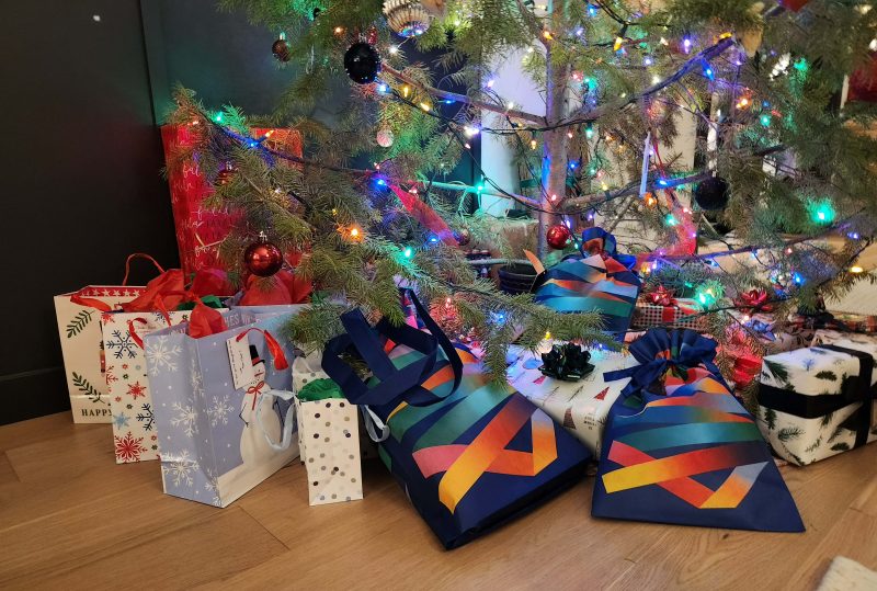
The presents are under the tree, . . .
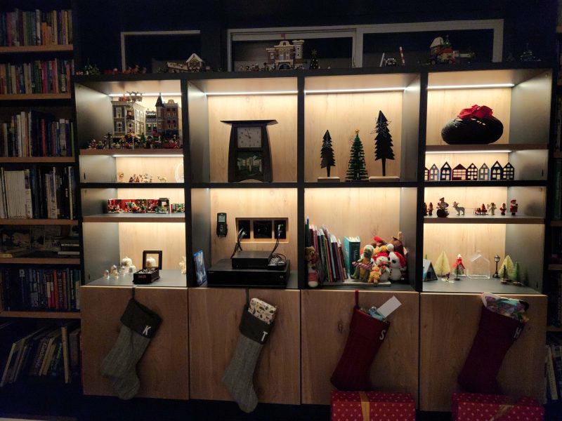
. . . and the stockings are hung on the bookcase with care.
On Christmas morning, Ted and I had a wonderful experience: Christmas with young children. What fun! Sefton is 8, and Hadley is 4, so Sefton read the gift tags and Hadley helped him distribute the gifts.
Christmas love and joy need to be shared.
We adults were fortunate to have Hadley present, because she helped all of us open every one of our gifts. The excitement of young children at Christmas is such fun!
Hadley wanted Dad to try on her red nose.
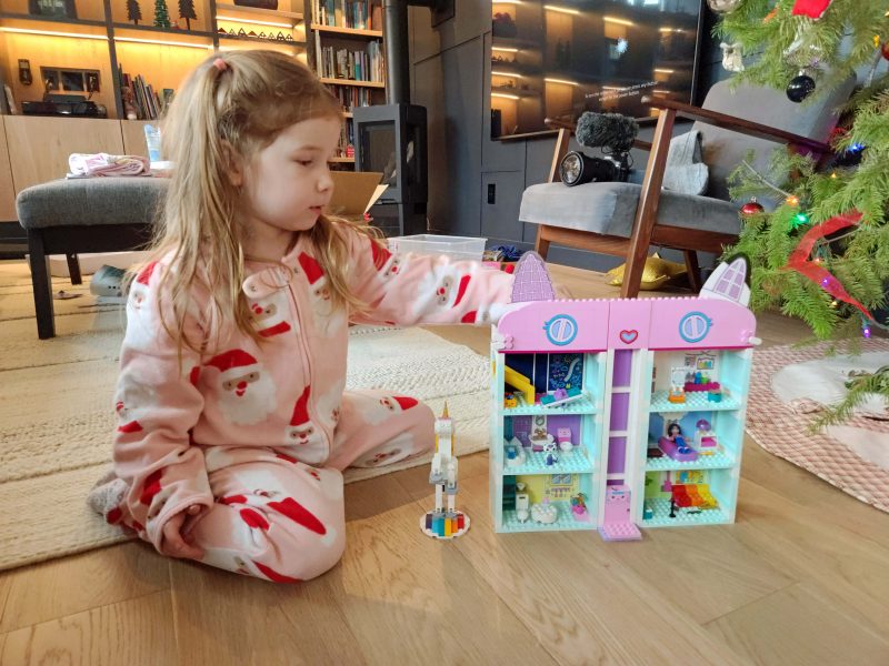
Here’s Hadley with her favorite gift–brought by Santa. The white Lego figure on the left side of the house is a unicorn, her favorite figure.
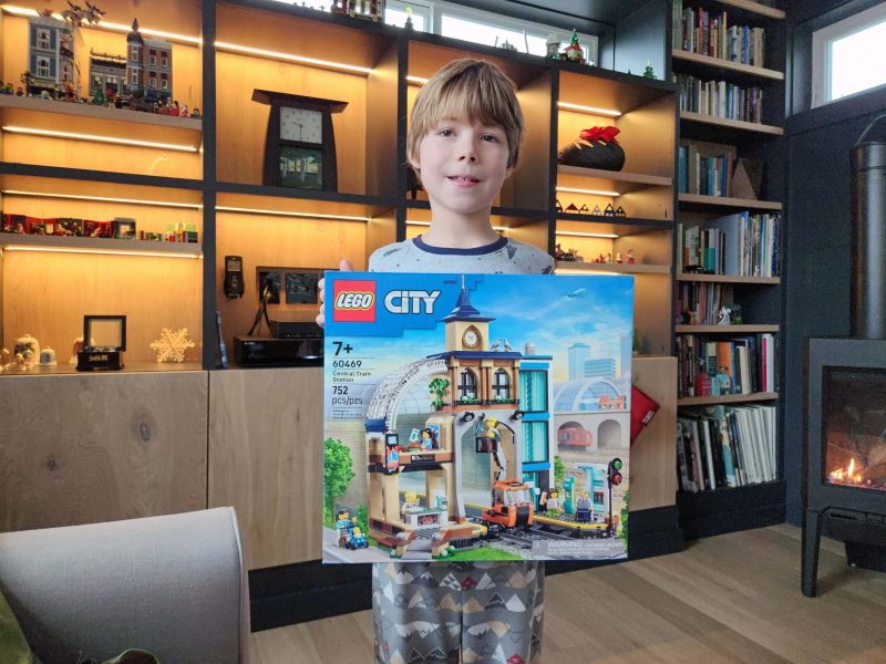
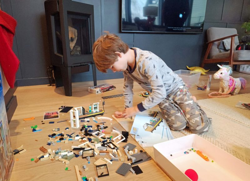
Sefton repeatedly reminded us that he asked Santa for a Lego City Central Train Station Building Kit. (He always included the full name of the set when he mentioned it, much like Ralphie [A Christmas Story] when he said he wanted an “official Red Ryder, carbine action, 200-shot, range model air rifle, with a compass in the stock and this thing that tells time.”) When Sefton discovered that Santa brought that set to him, he showed unbounded excitement. I took this picture after he finished repeating how awesome it was and settled down a little bit. This might be the only moment he stood still until he finished assembling it.
As soon as he opened the Lego set, Sefton announced that he was going to work on it all day until he finished it. With time out to open his other gifts and to eat meals, that’s exactly what he did.
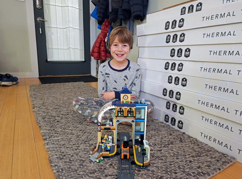
He finished building the train station before bedtime. It was exactly what he wanted for Christmas! Look at that smile!
This is exactly what I wanted for Christmas–time with our two youngest grandchildren.
When Hadley had to get up for some reason, she trusted me to hold all of her stuffies and to keep them safe until she returned.
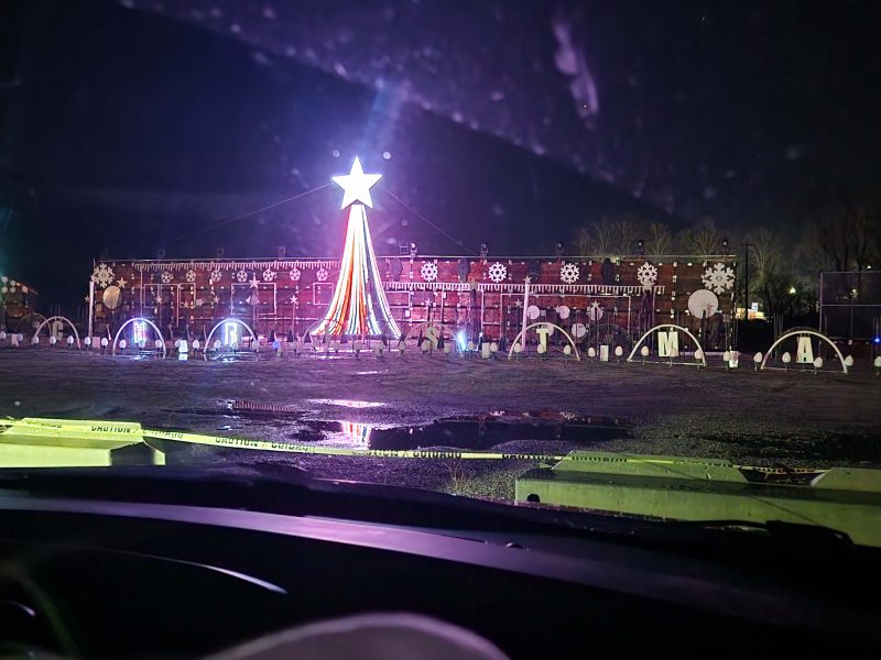
The following day–our last day in Wenatchee–Thom and Katie took us to a local Christmas light show. We parked in the front row and had a great view. The show lasted about 45 minutes before it recycled and started again. It was a lot more fun to watch than my pictures show because all the lights were moving in patterns and changing colors all the time. In addition, there was a soundtrack of holiday music that we could listen to on the car radio. My photos literally capture only a moment in time during the light show.
From the light show, we headed to Mission Ridge, where Thom and Katie treated us to dinner at a ski resort. As we climbed the road to the ridge and got above 3,000 feet, it began to snow. At the top (4,500+ feet elevation), it was like a blizzard, but a lot of people were skiing, even though the wind was blowing so hard that some of the ski lifts were closed. The road back to Wenatchee was downhill, curvy, and slick with snow until we reached a lower elevation. Thom used his winter driving skills to bring us safely down.
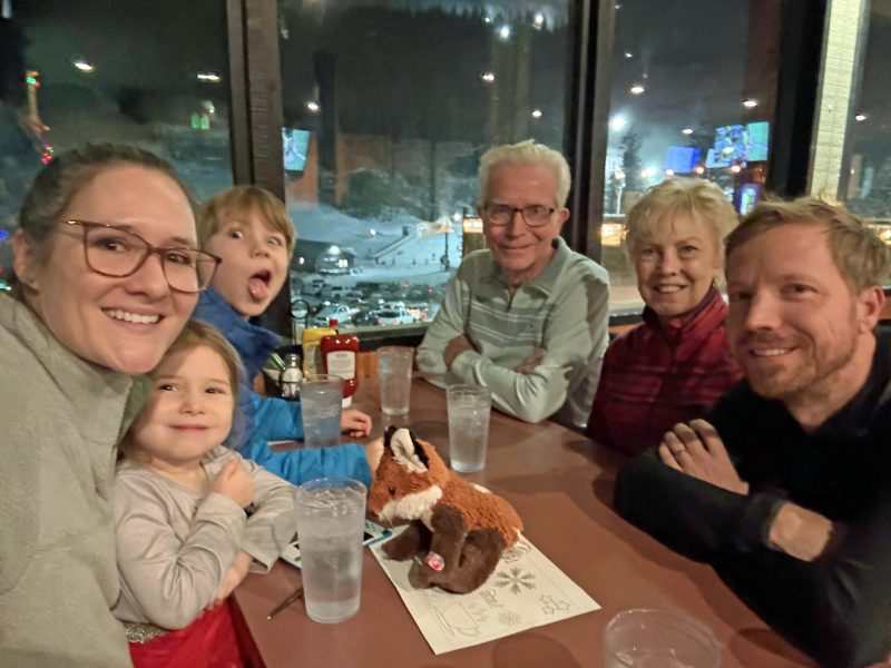
Katie took a picture of us while we waited for our delicious food to arrive. It looks like Sefton has spent a lot of time with Uncle Cosmo when pictures are being taken. 🙂
Before he went to bed that evening, Ted and I gave Sefton our gift for his ninth birthday, coming up in early January. We’ve never been with him on his birthday (see above, where I mentioned we usually visit during warmer weather), so it was fun to share even this little bit of his birthday with him.
He giggled while he tried it out, so we think he liked it.
The next day, it was time for us to leave, but Hadley sent gifts with us to enjoy at home. It was wonderful to celebrate Christmas in Wenatchee. We wish we lived closer and could see this family more often, but that doesn’t diminish the joy of our visits with them. Merry Christmas and Happy New Year to all !
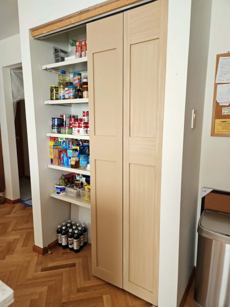
Ted and I are finally finished with the contractor jobs we needed to update the interior of our house. We started in August 2022 and finished in November 2025. We never believed it would take this long, but life got in the way and we put things off until–in frustration–we just said, “Let’s get it finished!” And that was all it took. Sometimes, you just have to bite the bullet, or whatever.
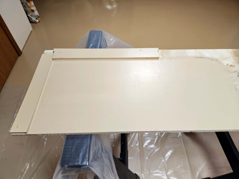
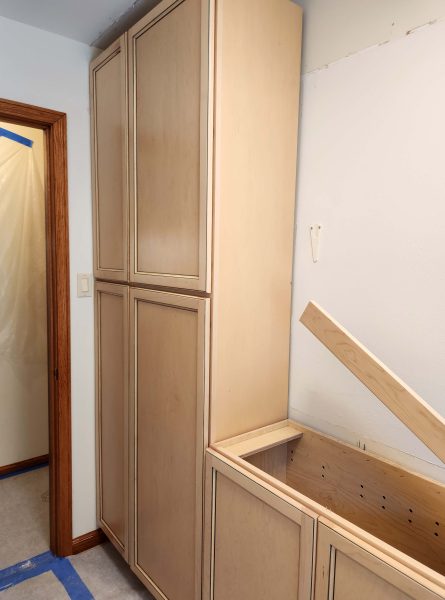
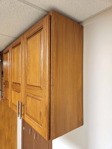
Here are the 46-year-old pantry doors that came with our new house back in the 20th century. They’re “builder grade,” but held up well. Still, 46 years! It’s time for a change.
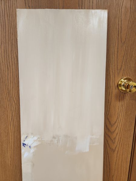
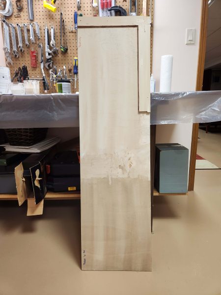
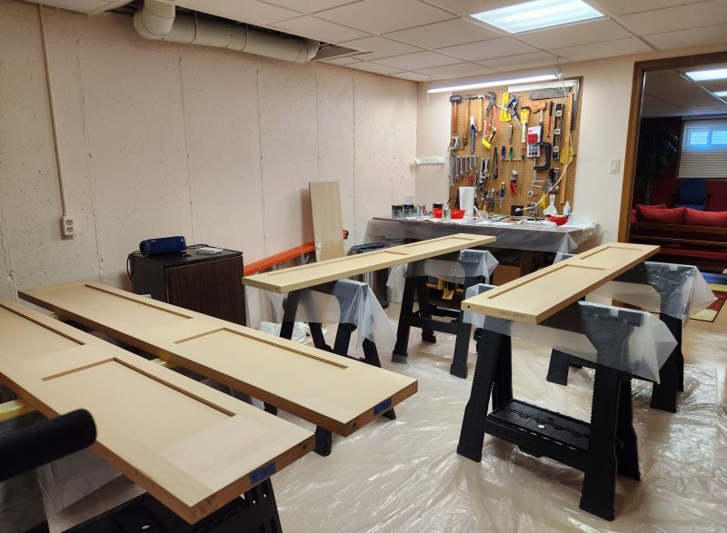
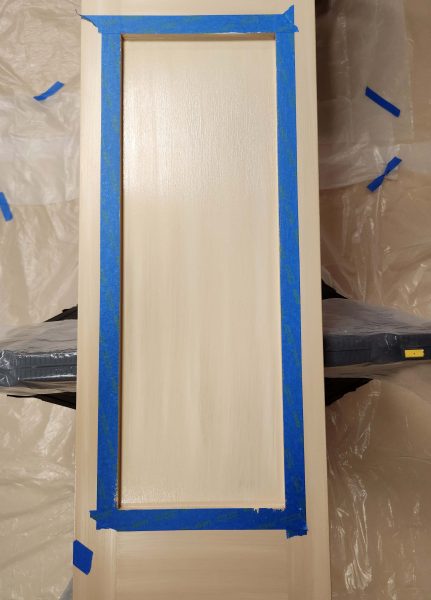
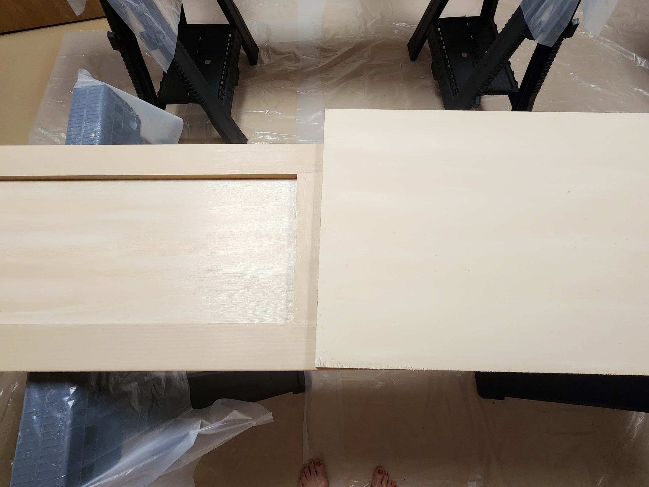
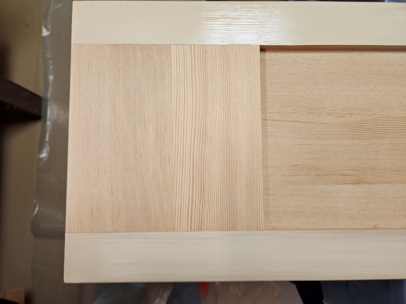
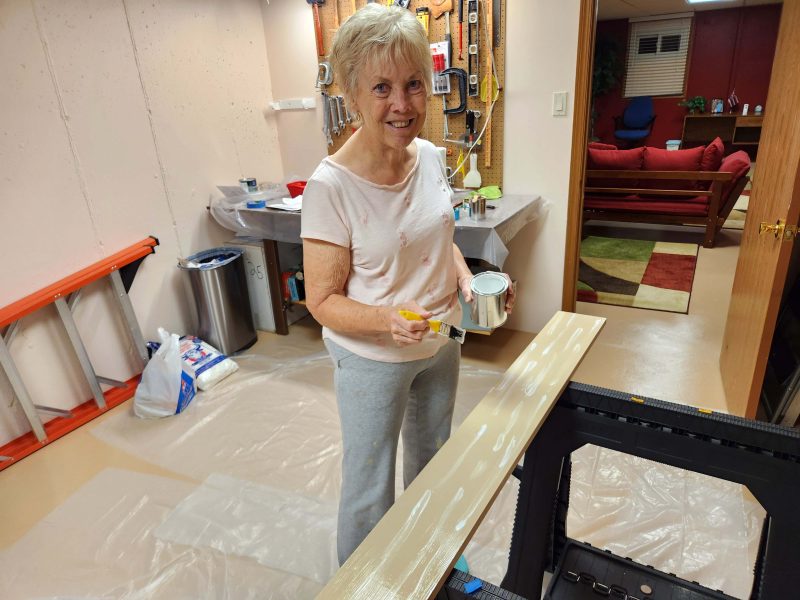
If you read my colorwashing story, you might remember that, when we finished colorwashing our new pantry doors, we set them up in the basement and marked them 1, 2, 3, and 4 with blue tape in the order we wanted them hung in the kitchen. We knew the doors were one inch too high for the pantry opening, so we painted the tops with the base color and left the bottoms bare because we knew they were going to be sawn off. In addition, I added a strip of blue tape with a message to “cut excess length from bottom.”
Sadly, good intentions can go awry. What’s wrong with this picture? I’ll give you a chance to look closely before you read on.
If you didn’t see the problems, look again and you’ll notice that (1) they are hung upside-down; and (2) the one on the left is hung backward with the plain side, rather than the colorwashed side, facing outward. I felt sick when I saw this.
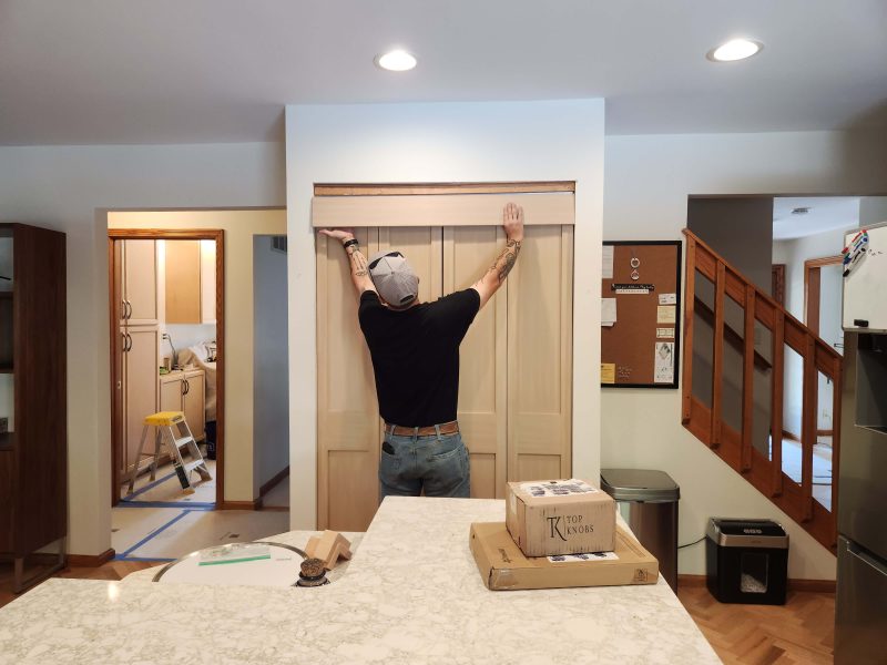
Before speaking to Mike, the carpenter, about the problems, I went online and looked up all kinds of door images. Just as I thought, when there is trim on a door, the wider piece of the trim is always on the bottom. Confident I was right, I said to Mike, “You know they’re upside-down, right?” His response was a puzzled, “They are?” Then I mentioned that one was also backward, and he was equally mystified. To compound the error, he’d already cut off the extra inch in height at the tops of the doors, because he thought those were the bottoms.
The doors were shipped to us in pairs and were already hinged together. We removed the hinges to colorwash them. Mike must not have noticed the holes where the hinges could be re-attached, because he drilled new holes on the opposite side of each door to fasten them in this order. Now each door had three sets of hinge-holes (my term) on both sides. Since we’d had the doors standing as they should be installed, lots of nasty thoughts were running through my mind, but I managed to keep them to myself.
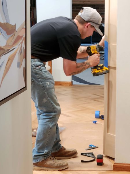
The problem was that Mike had only been working for Jimmy (the owner/contractor) for three months. Christopher, Mike’s more experienced mentor who was working on the laundry room cabinets, left for a short while to finish a different job, and instructed Mike to begin installing the pantry doors. Before Christopher left, he asked if Ted and I minded if they used our old door track (already installed) instead of the new one. I was puzzled, but figured, if it worked, it could be fine. Christopher went on his way and Mike kept working. Neither Ted nor I was feeling very positive at this point. In retrospect, I wonder if Christopher was trying to simplify the installation for Mike by not making him install a new track.
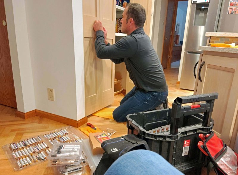
The installation was undone, the doors were turned to the right positions, the hinges were moved to where they belonged (at the original holes), and here’s Mike, drilling holes to attach the door pulls.
The final step (we thought) was to hang the door header. The edges on the lower edge were slightly rounded; the upper edges were cut square. At least Mike hung the header with the rounded edges at the bottom and didn’t have to re-do that too. (He apparently realized the value of my blue tape messages, so the arrows and words indicating “top” and “bottom” helped him this time.)
Unfortunately, the saga of errors continued.
(1) When the doors arrived at our house, all three hinges on one pair were bent. That package (a wooden crate) must have experienced trauma during the shipping process to shift the panels enough to bend the hinges. The guys couldn’t straighten the hinges, so they bought new ones. As it turned out, the replacement hinges were thicker than the original ones. When the doors were closed and the hinge plates on adjoining doors met, they made the doors too wide to function in the doorframe. The guys had to buy another set of thinner hinges. We were getting a lot of hinge-holes in our doors.
(2) The doors were not hung perfectly level, so when we opened and closed them, they rubbed against the outer walls of the opening and against each other in the center. Not only was this wrong; it was going to gradually wear down the wood and the walls at the contact points and scratch off our carefully applied colorwash on the center sides. Looking at the doors, it was easy to see a wider gap between the door and the wall at the top of one door and at the bottom of the other. It was also easy to see that one end was higher off the floor than the other.
(3) The new doors are much heavier than the old louvered ones. On the old track, the new doors opened too far and–the best I can describe it–backed up on themselves. They had to be pulled by hand from the wide-open position because the door pull had the wrong torque to do that. When they removed the old doors, the guys discarded the stoppers (spring-like things that fit inside the track). Without a stopper, the doors opened too far. The guys had also discarded the new hardware.
At this point, Jimmy brought in Tommy–a master carpenter–to see what could be done. Tommy did a better job of filling the extra hinge holes and he worked hard to level the doors. Unfortunately, to rotate the doors slightly to level them, he had to cut more off the top, which had already lost an inch that should have been removed from the bottom. Meanwhile, he was looking for something he could use that would provide a stopping point to keep the doors from opening too far, but he found nothing. Ted and I were becoming increasingly frustrated and unhappy. I was going to say, “Why don’t we just buy new hardware?” when Tommy said, “I think we should just buy new hardware.” He called Jimmy, who brought over some new hardware. Then Tommy rehung the doors, and made a few adjustments.
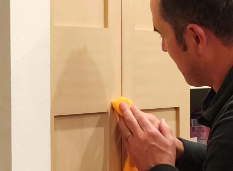
We thought the saga had ended, but the doors still didn’t work well. Jimmy came back to evaluate why they didn’t work as they should. After repeatedly opening and closing the doors using a variety of pulling/pushing touchpoints, he determined that moving the door pulls from the outer door panels to the inner panels would provide a different torque and would solve the problem. The downside: it would leave visible door pull installation holes on the outer door panels (more unnecessary holes on our doors!), but he thought he could fix that. He decided to try fixing one hole before drilling new ones. (Good idea.) Here he is, matching colors and applying them, blending them, smoothing them, etc.
In the photo below, he’s smoothing the lower hole. The upper hole is invisible, so he did a good job. It took him about an hour to get the right blend on the first hole; in another hour, he finished all three of the other holes. Twenty more minutes covered drilling new holes and re-installing the door pulls. Again, Jimmy is a good guy. He didn’t charge us for all those hours Tommy put in correcting and adjusting Mike’s errors, nor for the new door hardware. From what Tommy said (he was a talker), Christopher now knows that he should not leave a mentee alone on a job.
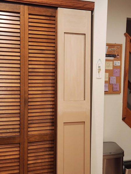
Everything works. The doors look nice. Ted and I are still disappointed with the process, but we accept the solutions. If you don’t know the saga (too late!), you won’t notice that anything was wrong. Ted and I have chosen to believe that, sometimes, things just go wrong, and this time it happened to us. Neither of us thinks it would be more fair if it had happened to someone else. Jimmy and Tommy did everything they could to make things right at the company’s expense, and it’s all good in the end. Don’t the new pantry doors look nice?
As long as we were going to have carpenters in the house, we added a little job to their list. Earlier this year, Ted and I disconnected our landline telephone. The problem: the white phone plate was still attached to the wall and it covered the hole where the phone line came in from outside. Fortunately, we have extra tiles from our 2023 kitchen backsplash update. The guys chipped out 4 tiles and replaced them.
After the grout was applied, you’d never know we had a landline on that wall, except that, out of habit, when we come home, we still look at that corner to see if the answering machine light is blinking with a message.
Ted and I are old enough to remember having the first phone installed in our parents’ homes, party lines, crank phones, dial telephones, long distance charges that were cheaper after 7:00 p.m., collect calls, person-to-person calls, pay phones, princess-style phones, wall phones, phone cards to charge instead of putting change in a pay phone, finally being able to purchase a phone instead of paying “rent” to the phone company for it every month, having more than one phone in the house (we had six before dropping our land line), answering machines, car phones, cell phones, smart phones. . . . We must be really old!
When Ted and I updated our kitchen in 2023, we replaced all the cabinets, but we kept the original 46-year-old louvered pantry doors because we didn’t know what style of new doors we wanted. (The cabinet manufacturer did not make bifold doors.) If we could see the new cabinets in place, we thought it would help us decide what kind of doors would look nice with them. Unfortunately, that didn’t help at all. Searching websites for bifold doors didn’t help either. The doors we liked were not bifold, and sliding or swinging panel doors were not an option, given the space we have to access the pantry. As time went on, the old, louvered doors looked worse and worse to us and more out of place with the new cabinets, but we still hadn’t seen anything we liked.
One night, I was reading a book and descriptions of the house in the story kept mentioning shaker doors and shaker cabinets, etc. If “shaker” was going to come up so often in the story, I needed to know what kind of picture to put in my mind while I was reading, so I searched for images of shaker doors. When I saw them, I showed the images to Ted, and bingo! They were just what we needed to complement our cabinet doors. The problem: all the doors came primed, unfinished, or finished with a color we didn’t like. Before we could move ahead and order the doors, we needed to decide how to finish them. When we pictured a uniform coat of paint, it seemed like a huge, 4×8 blank, block-like look, and we didn’t want that.
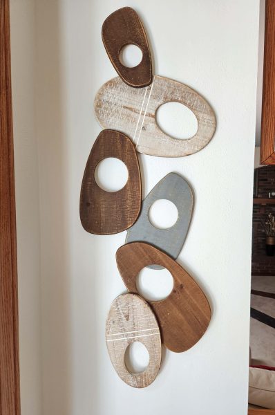
As I was looking around our kitchen one day, my eyes fell on the light parts of this wall sculpture we have, and a light bulb went off in my mind. I held the light pieces over our louvered doors and against the wall paint, then against one of the kitchen cabinets, and it looked good. Whitewash, I thought. That’s the finished look we needed! It would be more visually interesting than solid-color doors.
It wasn’t that easy. We took the sculpture with us to select paint samples that would look nice with a whitewash over them, but we didn’t like any of them. I contacted some painters for guidance–and perhaps a quote to do the job for us–but they didn’t seem to know what we were talking about. How tough is it to put on a decorative coat of paint? Did we really think we could do this?
Next, we went to an art studio for help, but they specialized in decorative glass and metal pieces, not walls or furniture. No one seemed to have any idea who else we could ask, and we didn’t want to order the doors until we knew how to finish them. Lacking in-person guidance, I went to YouTube to look for whitewashing videos, hoping for a clue. There were a lot of videos about whitewashing, but except for learning that the paints need to be diluted with water, I didn’t see any finishes that looked like what I had in mind.
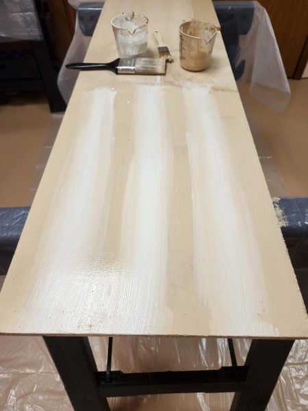
While I was searching, however, I came across a video with “colorwashing” in the title, so I clicked on it. It was closer to what I was looking for, but the lady was painting walls, and that wasn’t the look we wanted. Still, that gave me a new word to search: colorwash. Whitewashing videos far outnumber colorwashing videos, but I came across two that were doing what I knew Ted and I wanted to do. I played them, took screen shots, and made notes. (Once a student, always a student.) Feeling confident we could handle this, Ted and I ordered bifold, unfinished shaker doors. We wanted to finish the doors at least two weeks before the carpenters arrived to start our laundry room update so that the paint would be completely dry and wouldn’t chip easily if it bumped against something during the installation process. We had to get going.
And then the stress began. The doors were pretty expensive, and neither Ted nor I come close to being described as “artistic.” I can draw stick people, line outlines of a small house, and trees like first-graders draw them–a brown stem with a green cloud-like top. Ted might not be even that good, so I started getting stressed about how the responsibility of artistically finishing the doors might fall on me and how I might ruin expensive doors. Then I remembered something my mom used to say: “The only things I don’t know how to do, I just haven’t learned yet.” That’s a good axiom. I decided take Mom’s advice and to give colorwashing a try.
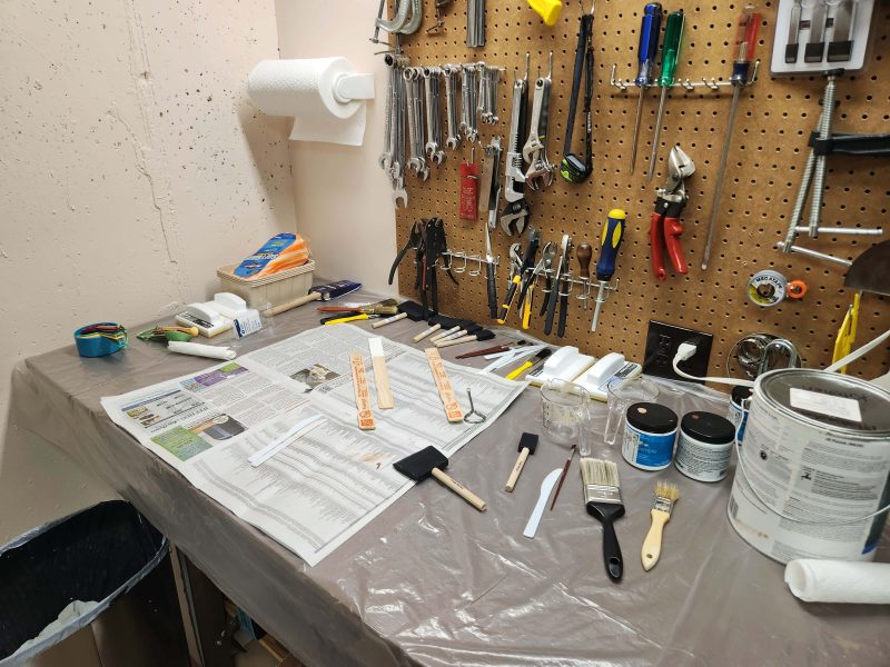
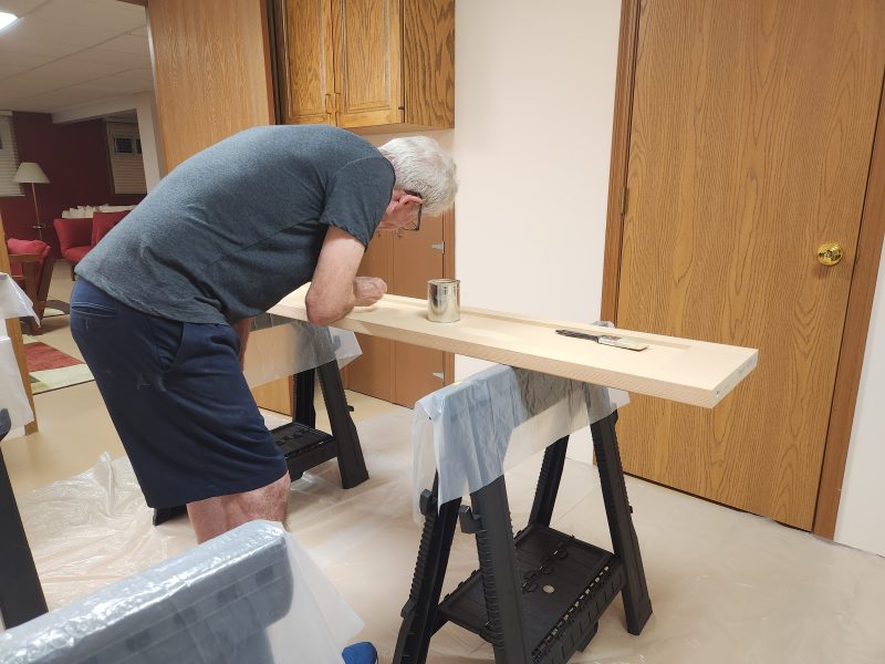
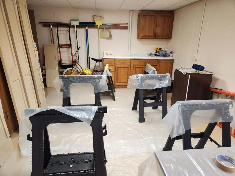
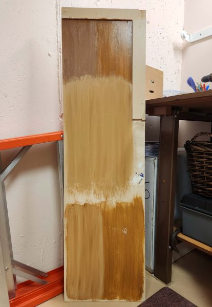
The videos mentioned that practicing before doing the real thing is a good idea. I definitely agree, so we went to Home Depot and asked where we could find a flat, naked piece of wood smaller than a 4×8 sheet of plywood. The man walked us to the back corner of the store, pulled a sheet of wood about 18 inches by 4 feet out of a large trash can, and handed it to me. There were no tags to scan, so I asked him, “How much?” All the wood in the trash can was scrap lumber, so it was free. Great!
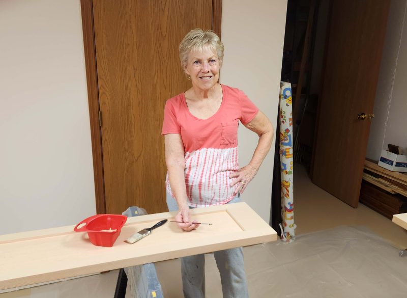
The first thing we had to do was select a color for the base paint and a color for the wash paint. We also bought the supplies the video told me we’d need: regular and feathering paint brushes, small containers to mix the paint and water, measuring cups/spoons to measure the proportion of water to paint so we could repeat it for the next batch, etc. We started with sample-size cans of paint in case we had chosen the wrong colors. (Remember, not artists.)
Spoiler alert: Step-by-step instructions of our mistakes and successes follow, just in case we forget how to do it another time in the future.
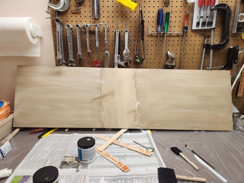
We started by putting two coats of the base color on our Home Depot practice board.
We tried different water-to-paint ratios and different brush strokes. Some on-line advice suggested a 3-to-1 ratio of paint to water, but that was too runny. After several tries, using a quarter-cup of base paint and gradually adding fractions of a teaspoon of water to the wash paint, we liked the look and the working viscosity of the paint with a wash ratio of 12 parts paint to 1 part water–a long way from 3-to-1!
When we thought we were close, we took the sample board to the kitchen to check the color match. Not good. It was far too yellow.
To get rid of the yellow cast, we decided to experiment with the extra-white ceiling paint left over from our 2022 house update. First, we brushed alternating columns of white over the dry base color.
That didn’t work because the wet paint couldn’t blend with the dry paint, so we got stripes instead of a faux wood-grain look.
Then we tried it again with a fresh coat of wet base paint.
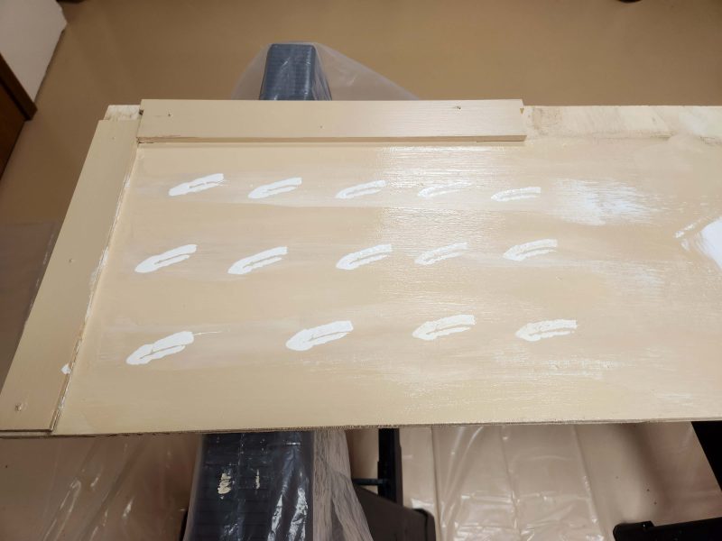
The wet-on-wet was better, but still turned out too stripe-y, so we tried dashes made by tapping the end of the paint brush on the wood.
That also looked too much like white stripes and was too white instead of evenly blended with the base color. While that paint was still wet, we dotted the white stripes with some of the base color and blended that in.
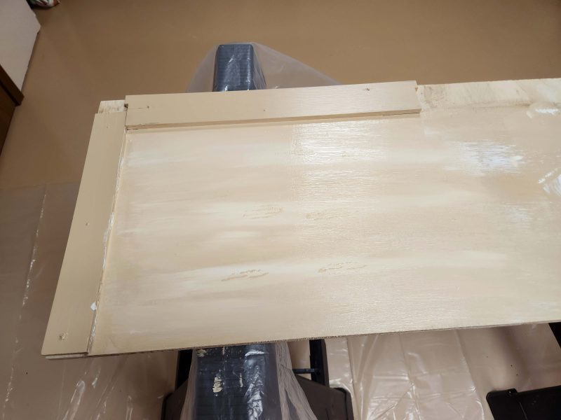
Not bad. That helped. The color looks better, but the stripes are still too visible and the finished look is too white. We went back to the practice board, re-painted it with the base color, and tried some other techniques. We soon lost count of how many coats of trial paint we applied to both sides of the practice board.
We’d been wondering if it would add visual interest to the doors if we painted the inside of the door trim edges dark brown. We found a can of brown paint left over from another project and tried it.
After days of experimenting with methods of how much to thin the paint, how much of each color to use, how to apply the wash color, and how to satisfactorily blend the two colors, we decided we were close enough to give colorwashing a go, but to be safe, we’d begin by working on the back side of one door. The only way to see the color on the back of the doors after they’re installed is to remove them and turn them around. If the colorwashing didn’t work, we could just paint over it with the base color again–our original plan for the back sides.
Good-bye, practice board. We went back to the basement and put two coats of the base color on both sides of the doors.
Working on the back side, we decided to try staggering, narrower streaks of white to avoid the striped look we’d been getting.
Staggered wet white on the wet base color is looking good. Keep blending.
There we go! Success! Just a little more blending is needed.
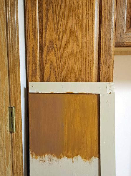
Our practice board pattern and color looked good when we compared it to the kitchen cabinet doors, and the back of this door matches it, Great!
We wanted to try the brown trim in a more realistic form than the practice board.
We only did the lower half of the door–again, because it was the back side and it was going to be re-painted in the base color anyway. We took it upstairs to see how the colorwash and the brown accent paint looked with the cabinets. The conclusion: the colorwash is satisfactory; the brown trim is a no-go.
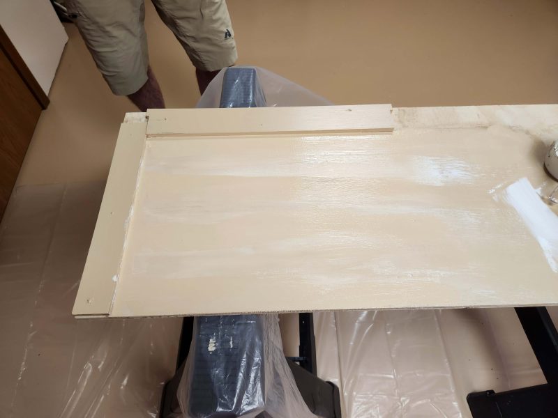
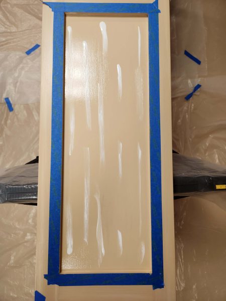
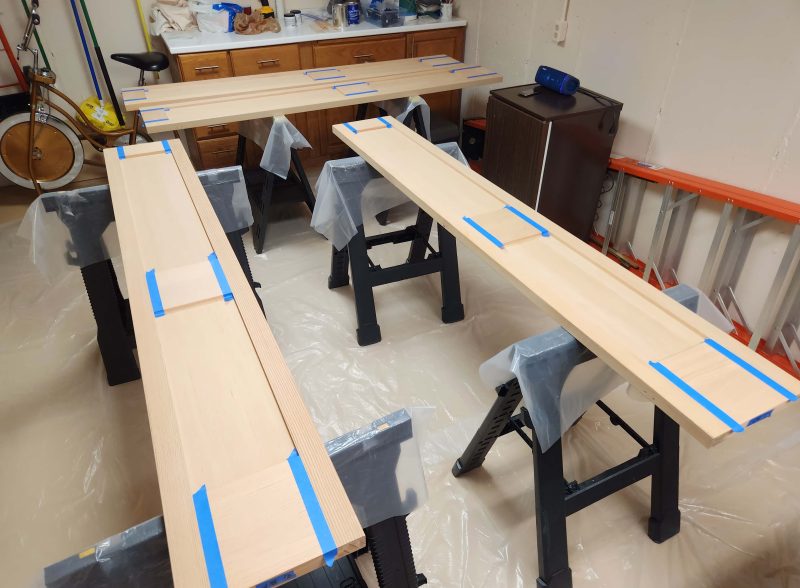
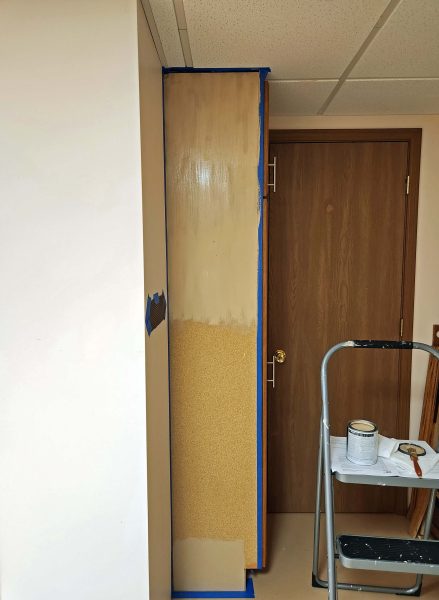
We went back to the basement to paint over that back side and to start colorwashing the front sides of all the doors. We decided to do the long, narrow outer trim strips first because we thought they’d be the easiest.
The blue tape left nice clean lines to colorwash in a horizontal direction next.
When we finished the front of one door, we pulled out one of the kitchen drawers to check our color match. Awesome!
With everything figured out and working well, we could really get moving. Here’s Ted painting the base color on the inner trim.
My job was to paint a skinny white line along that raised edge and then to blend it with Ted’s base color to colorwash the inside trim.
It took us about ten days to get from our first practice board trial to the last of the colorwash. Once we figured everything out, we averaged about an hour per door (front side only), including taping, painting, and colorwashing. We did the same thing on all four doors at once, then let the paint dry overnight so we could tape off the next section. It took three days to finish all four doors–vertical panels one day, horizontal panels the next, and inner flat surfaces last at just over an hour per day. After all the stress I suffered, what a breeze! Another thing my mom used to say was that anything you know how to do is easy. Right on, Mom!
The doors are finished. Here I am, colorwashing the header that conceals the track from which the doors are hung.
This is the finished header trim. The camera picks up every detail. It actually looks far less striped in person.
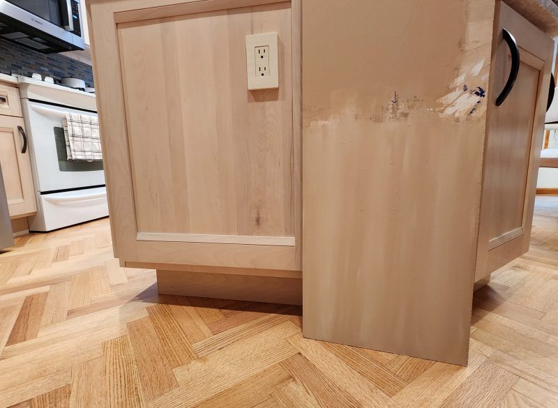
We did a (slightly) better job of colorwashing in some places than in others, so we arranged the doors in the order we wanted them hung and numbered them. That put the less-than-perfect areas in the shadow of the island and the best areas in the daylight. (Clever, huh?)
The door on the left is a back side with the base color. The door on the right is colorwashed.
We’re finished! It’s time to put away the sawbucks and the painting tools.
When everything was cleaned up, we celebrated by taking a walk along the riverfront in St. Charles and stopping for hot fudge sundaes at Kilwin’s. Mm-mm good!
As Mom said, anything you know how to do is easy. Now Ted and I know how to apply a colorwash. Need help with your project? Give us a call. 🙂
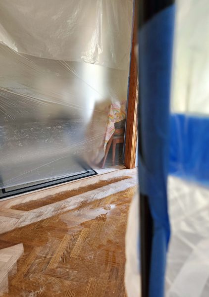
The laundry room was the last room to update in our house. We started in the usual way: empty the room and put everything in the dining room. When carpenters are working at our house, we always park our cars on the street so they can put their tool-filled trucks and their saws in the driveway. They store the supplies–and, this time, our washer and dryer–in the garage.
We wanted to extend our cabinets to the ceiling, so after removing the old cabinets, the first job was to remove the soffit. We were all surprised to see that the walls and the ceiling behind and above the soffit were already covered with drywall. That meant a discount on our cost. Yay! At the end of the first day, the carpenters, Christopher and Mike, brought one of the new cabinets indoors.
The next day, they brought in the remaining units and started installing them.
This is what our old utility cabinets looked like. One side provided storage for brooms, mops, etc.; the other side had eight drawers, most of which were filled with DVDs. We made it clear during the design process that we wanted the same design in the new cabinets, but . . .
. . . this is what we discovered when we opened the new cabinet doors. We expected two tall cabinets topped by two short cabinets. Instead, we saw four identical cabinets stacked and fastened together with an installed shelf (the wide horizontal bar) between the two units. The installed shelf made it impossible to simply remove shelves to make mop and broom space or to add additional drawers. Even if we could have done that, the doors wouldn’t align with the taller spaces in the lower units.
The left cabinet was 6-8 inches too short for brooms. (The broom is standing on the floor, not inside the cabinet.) Then we were told that manufacturers are moving away from customized cabinets. Really? It wasn’t a problem ordering our 1999 kitchen and laundry cabinets to size, nor was it a problem to order our 2023 kitchen cabinets to size within a 3-inch range (30, 33, 36 inches, etc.). Could it be that this particular manufacturer did not build custom-sized cabinets?
What to do? Jimmy, the owner/contractor sells high-quality merchandise, and we’ve always been pleased with what we’ve had him install–until now. We told Christopher and Mike that these cabinets were not what we made clear we wanted and thought we had ordered. They were useless to us because the mops and brooms wouldn’t fit, and there weren’t enough drawers for our DVDs. Without that storage space, we didn’t need these cabinets.
Christopher and Mike didn’t want to start installing cabinets if they’d just have to take them out later, so they called Jimmy. He came to the house soon after that with his master carpenter (34 years of experience), Tommy, to see what could be done to customize the unsatisfactory cabinets. The two of them talked for about 20 minutes and decided they could make us happy. We didn’t understand all the technical jargon, but the idea seemed feasible, so we gave them the go-ahead and the other carpenters went to work.
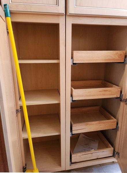
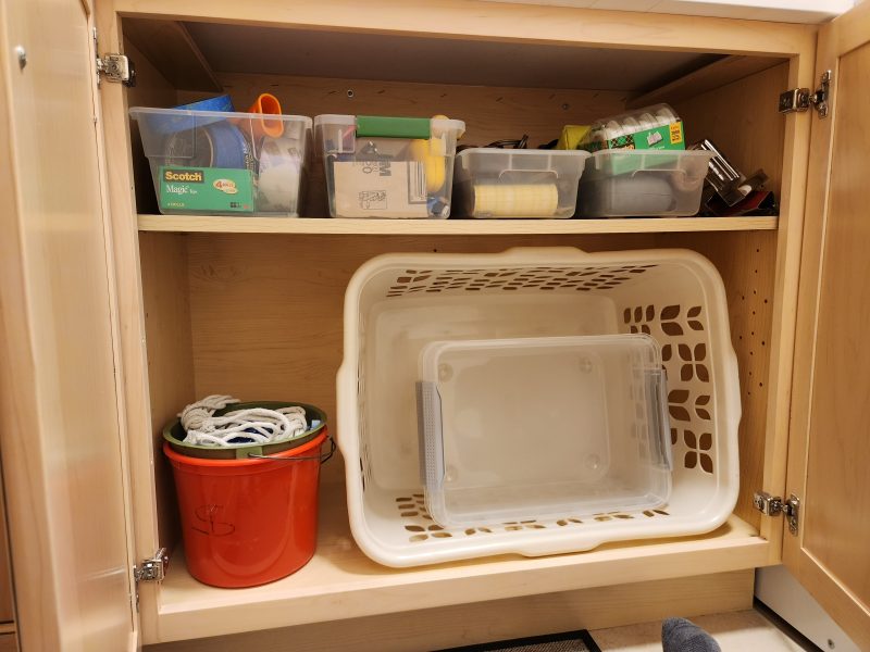
The next problem appeared when I started thinking about how I’d arrange our stuff in the cabinets with the extra room at the soffit-free ceiling. I noticed then that the cabinets only had one set of holes for shelf adjustments in the lower cabinet and only three sets of holes in the taller cabinets. Each set consisted of three holes drilled three inches apart (six-inch total distance). That meant I couldn’t store my laundry basket in the lower cabinet, where it’s always been, because the shelf adjustment holes were only in the centers of the side panels.
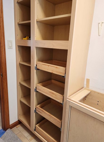
Ted and I don’t place our shelves evenly in our cabinets; we adjust the shelves according to what we store on each one. One or three sets of holes per cabinet was not good. Fortunately, the guys had a template they could use to drill holes any size and any distance apart, as desired, for shelf brackets. Go for it, guys! Now my laundry basket fits in the cabinet. Problem solved. If you zoom in, you can see the set of three holes inside at the right front of the cabinet and the strip of closer holes behind them. Note: the second plastic box from the left on the upper shelf is my “essential” toolbox.
The upper cabinets are installed. Note: This was the day of the ICE raid. Christopher, working on the upper cabinets, looked out the window and saw the law enforcement vehicles parking across the street.
Next step: install the trim at the tops of the cabinets.
Door handles and trim: installed.
And now, the challenge. First, wait for the three additional drawers that needed to be ordered. When the drawers arrived, Tommy, the master carpenter worked to customize these so-called “utility” cabinets. The process sounds simple, but doing the job well to make it as attractive as possible took time.
Tommy started by cutting out the horizontal shelving between the upper and lower cabinets. You can see the grooves in the side panels where the installed shelves used to be and the now-flush vertical scar in front of the left groove between the installed door hinges. That’s where he cut out the wide board that anchored the shelf in place and stabilized the joints between the upper and lower cabinets. Then he had to do some work to re-stabilize the cabinets. I wasn’t “snooper-vising” him, but I heard pounding.
Next, he had to uninstall the top three drawers and remove the drawer slides. The bottom drawer was already as low as it could be to operate smoothly. Ted and I had previously figured out how far apart the drawers had to be placed so that our DVDs would fit in them without wasting space between drawers (see the blue tapes). To accommodate our measurements, Tommy re-installed those three drawer slides lower and then the three additional slides above them.
When that was finished, he used matching wood–from a shelf that was removed from the lower left cabinet that we knew we’d never use–to fasten the upper and lower doors together and to cover the empty space between them. The down side of this solution is that the upper and lower doors now open and close as a single unit.
Result: We have utility cabinets with room for brooms and mops, and drawers for DVD storage. The door arrangement is unusual, but it works.
Jimmy is a good guy. We’ve never had problems with his products or service before, so we had a private talk with him about how disappointed we felt. He apologized and told us it’s hard to find skilled carpenters, so he made the decision to hire younger carpenters and pair them with his more experienced carpenters, hoping the younger ones will continue working for him. He didn’t charge us for any of the extra customizing labor.
Here are photos of the c. 2000 laundry room and the 2025 laundry room. We definitely like the lighter, brighter new look.
The cabinets are new, but we still have our 30-yer-old Maytag washer and dryer. They just won’t quit working!
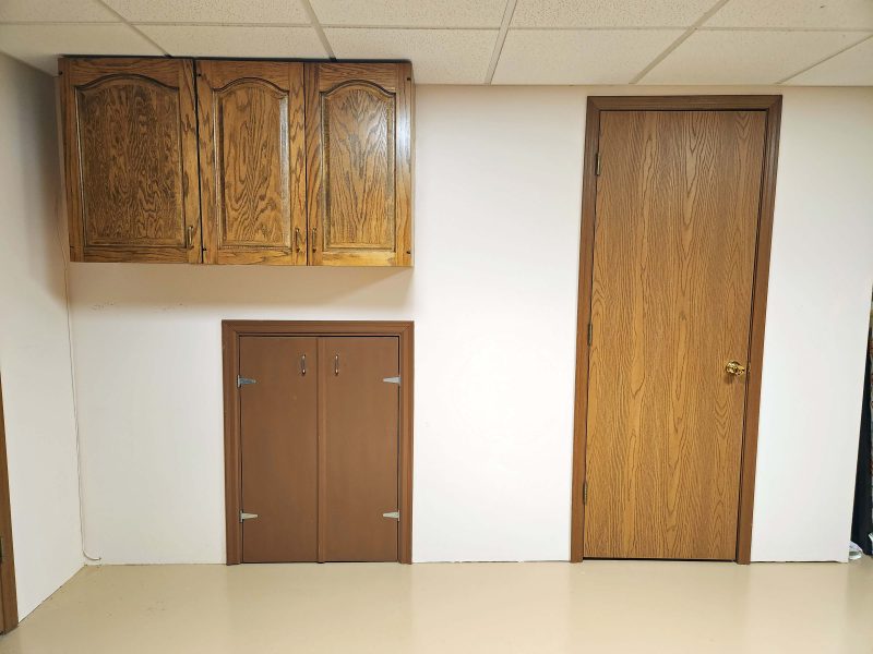
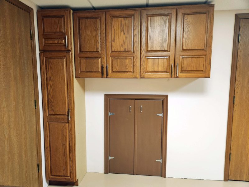
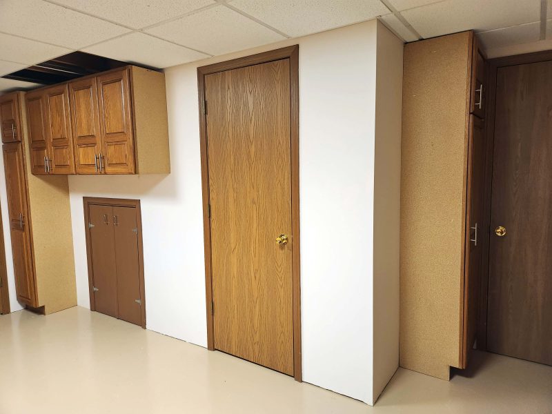
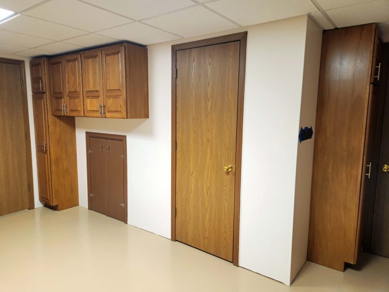
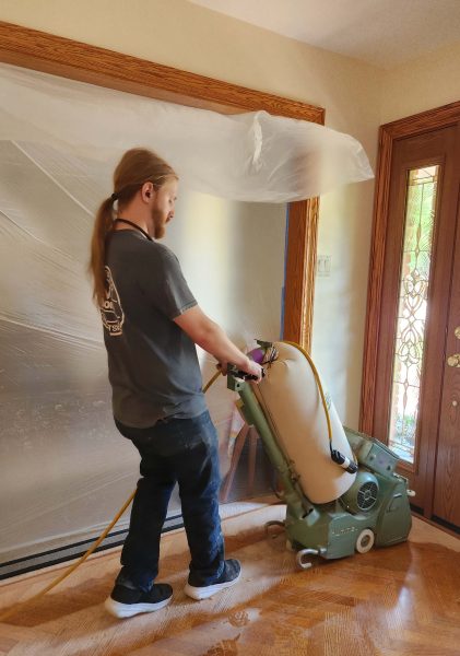
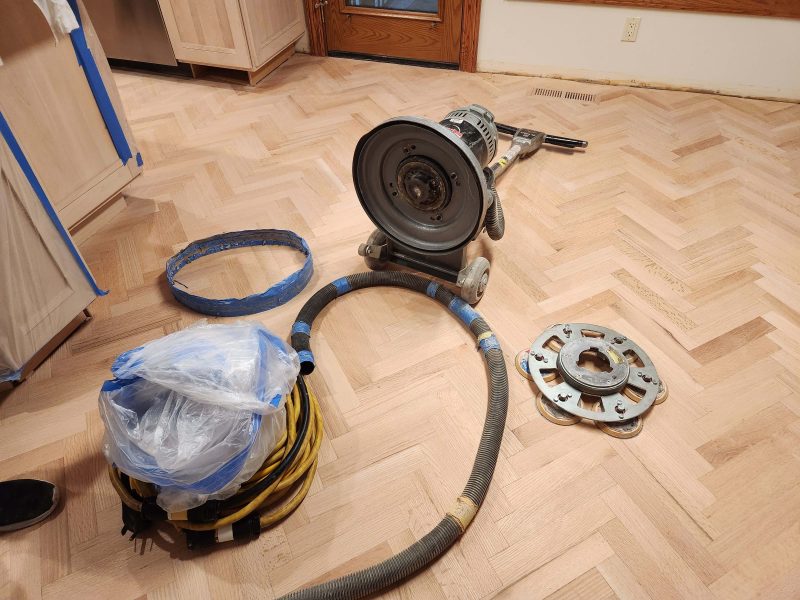
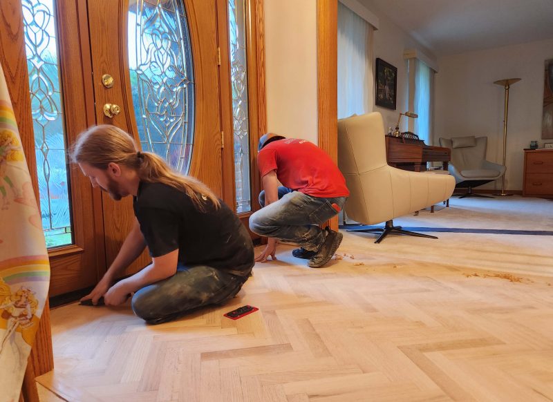
The laundry room and pantry door stories should come first, but the carpenters–who were doing all three jobs–finished the basement first, so that’s where I’m starting.
First, the basement bathroom. The sink in the next two pictures doesn’t look too bad but, in person, it had yellowed greatly and looked awful with the white tile floor, the white toilet, and the white shower. It was time for a new vanity top.
Our old sink was Corian; this time we chose quartz. While I was talking with the sales lady about the quartz top, she mentioned that the quartz used for countertops is not actually made of rock because quartz is not a rock. I tactfully did not correct her that quartz is, indeed, a real rock and that “quartz” countertops are fabricated to look like actual quartz rock. Here’s the not-real-quartz pattern we chose. It gives the bathroom a nice, fresh look.
Back in 2023, when we updated our kitchen, we had some of the old kitchen cabinets installed in our basement workshop. There weren’t enough kitchen cabinets in the sizes we wanted to finish the job, so we planned to add old cabinets from the laundry when we updated that room. These are the last of the original cabinets that came with our new house 46 years ago.
Now, those three (antique?) cabinets have been replaced with four (relatively) “new” 27-year-old overhead cabinets and a utility cabinet, plus another utility cabinet around the corner of this wall. The laundry room cabinets live on!
I didn’t like the seeing the three unfinished sides of the cabinets (they were originally against other cabinets or walls), so having learned how to colorwash (story coming up), I decided to colorwash the unfinished sides. Note: The crew replaced the missing ceiling tiles a few days later.
I got out my practice painting board, Ted and I selected paint colors that seemed to match the colors in the wood of the cabinets, and I went to work, trying a variety of styles and colors to choose which looked best. They were mostly awful!
A closer look at the top right sample on my practice board showed a possibility. The base color paint showed through the colorwash paint, creating a wood grain appearance. The idea seemed so simple after what we went through with the pantry doors (yes, coming up). Just put on two coats of the base color and paint over them with a single coat of the wash color? How easy is that?!
I had to remove a cabinet door to paint the upper strip on the utility cabinet. Then I taped all the edges and started painting.
Here you can see the start of the first coat of the base color. The second coat looked far more uniform, as second coats usually do.
Here’s the faux wood grain look of the wash color. I used a feathering brush to smooth out the streaks a bit.
And here’s the result.
The strip between the two cabinet doors in the photo below is colorwashed. I think I achieved a pretty good color match.
We like the finished look much better than those unfinished panels.
Now that the hardwood floor in the kitchen looks so nice, I decided we needed new coverings for the blind headers on the windows. Ted and I went shopping for fabric and found a piece with a design and colors that were perfect for our kitchen. There was just one problem: it was upholstery fabric, not drapery fabric. That means it was thicker, had an applied backing, and frayed more easily than drapery fabric. I’m an excellent seamstress, so I took on the challenge. I didn’t know it would turn out to be a bigger challenge than I’d expected.
Even though I only wanted to wrap the fabric around the blind headers, there were problems to solve. With drapery fabric, I’d cut a long rectangle, fold it in half lengthwise, sew that long seam together, turn over each end to sew hems, and slide the tube I’d made over the header. Upholstery fabric is a different story. One problem is that upholstery fabric is thicker so it can take the wear and tear of furniture use, where draperies and curtains simply hang against the wall–or window–and get dusty. My “wrap” (as I call it) also had to turn two corners from the front of the header onto the returns that attach the front piece to the window frame. The thicker fabric bunched up heavily at the corners and, if it fit the header, it was too tight to slide over the returns. My solution was to make the wrap slightly wider from the corners to the window frames to make it fit around the corners and the return pieces.
The wrap at the bay window was longer than the width of the fabric, so I had to match the fabric pattern at a seam. That seam was bulky where it folded over the top and bottom of the header. My solution? I notched it at the folds to allow it to bend more easily with less bulk.
Folding over a hem at each end was tricky too. I usually double-fold the ends, but that was far too thick with upholstery fabric, so I zigzagged the edges to prevent future fraying and settled for a single fold-over. The double layer of fabric at the hemlines made the wrap even tighter over the returns. That’s where my solution to make the wrap a little wider in that area really helped. My finished pieces weren’t simple rectangles; they were long rectangles with flared ends.
It didn’t surprise me that I triumphed over the challenges. I’d have given up if Ted and I hadn’t liked the fabric color and the pattern so much, and if we hadn’t agreed that a runner-up piece of drapery fabric would always be second-best. Still, making everything work was more frustrating than fun, so in the future, I’ve decided to avoid buying upholstery fabric for window hangings! That is, unless it’s this perfect for the look we want.
Here are before and after photos of the new wraps–old, then new.
We like the colors of the new wraps with the new cabinets. They look warmer and less “washed out.”
See how well that pattern matches our new light (part of the 2022 update) and the colors in the wall sculpture? I couldn’t say “no” and I’m glad it worked out.
Ted and I started updating the interior of our house in 2022. We made electrical changes (halo lights in the ceilings, a light wall in the family room, etc.), we had all the walls painted, and we replaced all the carpeting. In 2023, we updated the kitchen. After that, the only remaining jobs were to refinish the hardwood floor, update the laundry room, and get some new pantry doors. Our current pantry doors were in the house when we bought it new 46 years ago. They held up well, but their age was showing.
We started by going to our favorite contractor to start planning the laundry room update. Of course, working with his designer, making choices from samples, selecting the cabinet style we wanted, etc. all takes time. Then the stuff has to be ordered and the contractor has to find a place in his schedule to do the job for us. Meanwhile, we decided to get started on refinishing the hardwood floors, which would take less time. In fact, they did the job a week after I called and finished it in four days. Wow!
We started by emptying the pantry and the closets so the team could work on those floors.
We knew everything would get dusty from sanding the floor so, as long as we were taking down the blinds, we decided to wash them. There was lots of floor space to do it.
Everything got piled in the dining room, where it would be out of our way during the project.
We moved the kitchen table to the family room and took out the leaves to make it smaller. That gave us a window view while we ate meals during the work time.
Then the team of two arrived to start working. They spent a block of time protecting as much as possible from the dust they were going to create. They wrapped the refrigerator doors separately to allow us access to the refrigerator. We could also use the microwave.
The stove was moved to the family room.
They covered the doorways with plastic and wrapped one vertical edge of the plastic at each doorway around a spring tension rod. That allowed us to use other rooms–we just had to move the rod aside far enough to squeeze through, then put it back against the door frame.
Then the mess began. “Dusty” isn’t a strong enough word, although the plastic coverings helped a lot. After the entire job was finished, Ted and I cleaned the entire house, including wiping down the walls.
This is a view of the bottom of the sander. The large disk on the floor spins and each of the six smaller disks on it also spins. All that action prevents sanding strokes from showing on our herringbone floor pattern.
The edges and corners needed to have the old stain and varnish scraped off and sanded by hand. You can see some of the scrapings on the floor in the center right of the photo below.
When everything was sanded, it looked so light and clean that we hated to put a colored stain on it. It felt really smooth too, compared to our 27-year-old pre-refinished floor.
From an array of stain colors, we were allowed to choose four to be applied to the floor to help us select the one we wanted. From our four choices, we went for “natural,” the lightest one.
For the finish coat, we chose a low-sheen finish, rather than a gloss.
When the guys finished the job, they left a little gift for us–wood floor cleaner and a Bono mop.
The following are before and after pictures of the floor. We can’t believe how much depth and color are revealed with the lighter stain! It’s even better than the clean, sanded look.
This floor extends to every exterior door and to every first floor room, as well as to the stairways for access to the basement and to the second floor. On the day the finish coat was applied, we needed to leave the house for a few hours to let the finish dry enough to walk on it with socks, so we went out to dinner.
On our way home, we saw a rainbow–a good sign for a successful, beautiful project.
When I was a child (elementary school) growing up in Wisconsin, my friends and I often went ice skating or sled riding at night. One night, while we were sledding, I remember seeing the Northern Lights in the sky. I watched them for a little while, then went back to sledding with my friends. It was pretty, but I didn’t realize at the time what a remarkable event I had just witnessed.
The last time the Northern Lights were visible in this area was May 2024, but Ted and I were not able to see them. Thanks to a major sun storm this week, the Northern Lights were visible again as far south as Missouri. This time, we joined a crowd at a nearby park and saw a beautiful light show.
After leaving the park, we drove to the top of a hill in our subdivision and we could see the Northern Lights from there as well. Surprisingly (to us), no one in the neighborhood was outside looking at them.
On one of his weather-related websites, Ted found these pictures of rare white Northern Lights that were seen in Alaska during this solar event. Beautiful!
Jeff and La came from their Montana home for a visit at our Missouri home and–no surprise–we had a great time together. The weather was nice, so a bike ride was on the menu.
Because I know that La likes puzzles, I showed her the puzzle Kathy gave me for Christmas last year. It has the most unusual pieces I’ve ever seen. There are letter-shaped pieces (LOVE) and pieces shaped like hearts, bunnies, flowers, leaves, butterflies, animals, etc. The edges are irregular, so there are no “edge pieces” to start with. I’m not that addicted to puzzles, so I put it away.
When La saw the pieces, she started looking for ways to put them together. It wasn’t long before Jeff and I were helping her. It was challenging at first because the picture of the puzzle was printed on a larger scale than the finished puzzle, making it hard to judge the perspective of where a particular piece should be placed. (Compare the small group of tiny pieces on the table with the large picture in the photo below.) With three of us working on it, I think it only took about an hour to finish the puzzle.
Look for those specially-shaped pieces in this close-up of the finished puzzle.
We spent the following day at Kari’s house with her family. Theo’s girlfriend, Lizzy, joined us and we all had a good time playing some games together.
To stretch our legs, we went to a nearby park and followed a circular path (1-2 miles) around the park.
Ted took a picture of our group.
One day, about a month before Jeff and La’s visit, I wanted to use my laptop computer, but when I turned it on, I saw a screen filled with (to me) gibberish. I tried all my (limited) tricks for rebooting a computer, but nothing worked, so I took it to the Geek Squad. The Geek’s verdict was that either the hard drive or the battery was kaput. My laptop could be fixed, but the cost of a newer laptop would be comparable to the cost of the repair. I decided to replace my 9-year-old laptop with a new one.
Ted and I had an exceptionally full schedule, so I had to fit loading my new laptop with my own software and files in between all the other things that were going on. It seemed to take forever, so I just decided to wait for Jeff to come, hoping that he could show me a faster way to get the job finished. He helped me with that and suggested I give up my (also aging) PC tower and simply connect my larger monitor, my keyboard, and my mouse to the laptop. I liked that idea and I like working with my new setup.
While Jeff and La were visiting, Jeff spent some time having lunch and catching up with friends one day. While he was gone, La, Ted, and I enjoyed a delicious salad lunch. We also had family gatherings that included Kari’s family at two of Ted’s and my favorite restaurants–Fratelli’s and Dewey”s.
The federal government was shut down during Jeff and La’s visit, and there were a lot of airline delays. The day before they left, Jeff and La learned that their flight home had been cancelled, but they were able to reserve seats on another flight. They had a class to teach in the evening and didn’t want to miss it, so they needed to choose the early morning flight that required us to leave for the airport at 4:30 a.m. None of us was thrilled about that, but it worked. Ted and I went back to bed after we returned from the airport, Jeff and La had a safe flight home, and they taught their class that evening.
I love family visits. Here’s a photo Jeff took of all of us.
My dad was an outstanding mechanic. His gifts to me when I left for college were a flathead and a phillips screwdriver, a hammer, a pliers, and a 6-inch adjustable wrench. Unusual gifts for a college woman, to say the least.* I must have exhibited enough interest in helping Dad with little jobs and watching him work that he realized I’d want to keep my things in working order after I left home. I quickly discovered that those tools were some of the most useful things I brought to college, and I still have them. (Dad didn’t buy low-quality tools.)
Word got around, and my dormmates often came to me, asking to borrow one tool or another. The same thing happened when I worked in an office. Loose drawer handle? Picture to hang? My staff knew I had some tools, and they knew it was faster and easier to borrow my tools than to put in a maintenance order.
Ted has tools stored on the shelf below the workbench in our basement workroom as well as in some of the cabinets in that room. He’s less adept–but stronger–with tools than I am (his dad was not a mechanic), so I often say that I’ve bought him all the tools I need. All of Ted’s tools are useful, but many aren’t used very often. For those little fixer-up jobs that need attention, I keep a toolbox (actually, a plastic shoebox) handy in our laundry room so that I don’t have to go to the basement to get a hammer or a screwdriver for a two-minute job. My toolbox/shoebox is stocked with “essential” tools for little jobs. It has small, medium, and large flathead and phillips screwdrivers; a hammer; a level; a 4-inch and a 6-inch adjustable wrench; a 12-inch ruler and a pencil; a 25-foot steel tape measure; two sets of allen wrenches (metric and English); etc.
My toolbox/shoebox was getting pretty full, and it shouldn’t be (see “essential”), so I dumped it out one day to sort out my essential tools and those that could be stored with Ted’s for occasional use. During the sorting process, I discovered a second hammer that I don’t remember having. The hammer is small–only about 8.5 inches long.
But, . . . it comes apart and provides 2 flathead and 2 phillips screwdrivers as well. It’s a semi-essential tool kit in one unit. Nifty!
I can’t believe I didn’t remember that I had something this useful. Sometimes, you don’t know what you have until you find it!
* Dad was not a demonstrative man (huge understatement). On the day Mom drove me to college, Dad said, “I love you,” with the tools and with the words “Don’t get involved in any of those ‘Students for Lincoln’ or whatever clubs.” Translation: Those were the days of large, sometimes violent, student protests against Dow Chemical Company–the maker of agent orange–and against the Vietnam War. Members of the SDS (Students for a Democratic Society) were the most violent protesters. UC Berkeley and UW Madison were among the most active and vocal protesting colleges in the nation with large SDS memberships. Dad was worried that I’d be hurt in a demonstration and/or be put in jail like so many of the protesters.
Jeff was playing with an AI app one day and decided to make his dream of being in a band come true. He actually played the drum for a short while in elementary school. Look how far he’s come.
If his dreams can come true, I asked him to fulfill my dream of becoming a super model. He did it.
One day, while I was sitting on the patio, I saw the brightest-colored caterpillar I’d ever seen.
I searched “neon-yellow caterpillar” online and learned that it’s a Polyphemus moth caterpillar, a member of the giant silk moth group. The moth is one of the largest moths found in Missouri.
I don’t remember ever seeing a moth that looks like this, but I admit that I don’t generally spend my outdoor time looking for moths. Still, it’s good to learn something new every day and now, if I ever see a spotted moth like this, I’ll know its origin. If I catch one, maybe I can make silk. 🙂
A few days ago, Ted and I were shopping at Lowe’s. It was hard to know which seasonal decorations we should place in our yard–Hallowe’en on the right or Christmas on the left.
On another day, we were shopping at @Home and saw the largest display of Christmas decorations we’ve ever seen. @Home is a huge warehouse store and everything we could see from the entrance (this view) was on aisles that extended nearly to the back wall ahead of us and to the the outer wall on the right. Is this The Land of Plenty or what??
Jeanette was the first staff member I hired when I became an administrator at the community college. It was a great choice! She and I have been good friends since we first met. Other staff members used to joke that we shared a brain because our ways of doing things were so similar. Although she’s Hispanic and I’m blonde, we often came to work wearing the same colors–not something you’d expect from people with such different coloring.
Two years ago, Jeanette had a double-lung transplant. It was a tough recovery (h-u-u-u-ge understatement), but she’s doing well and, except for still tiring easily and wearing a mask outdoors to avoid contaminants in her lungs, she’s back to normal. We’ve been meeting for lunch since she became strong enough to do that, and we had a recent get-together at Panera’s.
We missed the third member of our trio, Gail, who moved to Virginia two years ago. We were “tres buenos amigas.”
Family and friends are the greatest gifts in life.
Kari invited me to an event at the library that sounded like fun. Two local women recently published cookbooks–one on soups and one on pastries–and were the guests at a book signing event.
The moderator had excellent questions and the two women had interesting answers. The hour-long event went by too quickly. Both women have always loved cooking. The “pastry lady” has a local bakery; I don’t remember if the soup lady works at a restaurant or not. Some of the interesting things they said in the interview portion of the evening included the following:
–When people ask me how long it took to write my cookbook, I tell them “30 years.” It only took 4 months to get the book published, but she had perfected her recipes over a 30-year period.
–When you write a cookbook that you want people to use, you have to be very clear in your directions. You cannot assume their knowledge of cooking matches yours, so you need to define terms like “simmer,” “cream,” “fold,” “dice,” etc. If they don’t understand your directions, their end result will not be successful and they’ll never open the cookbook again.
–You can’t take a recipe you’ve made at the bakery in a batch that yields 5 dozen pastries and divide it by 6 to yield only 10 pastries for a home cook. The proportions of the ingredients change with the size of the batch of dough.
–When asked which ingredient they could never do without, the two women looked at each other, laughed, and simultaneously said, “Butter!”
Kari and I each bought a soup cookbook and had the author (pink sweater) sign our copies.
As you can see, I’ve already selected the first 5 soup recipes I want to try.
A few days later, Kari was shopping and saw the pastry book on display (“Made. by Lia”).
It was a fun night out and we’re both looking forward to some new items on our home menus.
For many years, Ted and Kari have observed two fall traditions: (1) they wax her car together; and (2) they mulch her leaves together. 2025 was no exception.
This year, however, Ted added an event–he invited Theo to come over for a car waxing afternoon.
Ted also waxed our cars and mulched the leaves in our yard. The car waxing event repeats in the spring. If Theo participates again, that will count as a new tradition. Long live family car waxing and leaf-mulching!
For years, our friends and family members have been telling us how much they love their toaster ovens, so Ted and I finally decided that we ought to buy one. It wasn’t hard to find one we like (Breville), and it didn’t cost a fortune, so we drove to Target, picked it up, and joined the toaster-oven crowd–just like that!
Our excuse for not buying a toaster oven sooner was that we don’t have enough empty counter space for it. That problem was solved by rearranging a few things in one of our island cabinets. Now we can simply pull out the drawer, lift the (not heavy) toaster oven up, plug it in on the side of the island, and do any of the 10 functions we choose. It’s definitely faster than heating the oven, and it doesn’t warm the kitchen as much.
It’s been very convenient to bake just a few cookies at a time and to eat them fresh and warm. Although we’ve already used our toaster oven for a lot of things, this is the first thing we made.
It was delicious! All those people were right: a toaster oven is a good thing to have. What took us so long to get one?!
The northern states seem to have only two seasons annually: winter and road construction. Ted and I hit a lot of road construction on our way from visiting Ted’s brother to seeing our grandson in Rockford, IL. As a result, we arrived about an hour later than we’d planned. It was fun to see Sky’s Star Wars-themed apartment. If there’s Star Wars merch, Sky (named Anakin Sky) probably has it. Ted took a picture of Sky and me. Check out the coffee table–and underneath the coffee table–and the helmet on the right. And this was just the beginning of the themed décor.
We had a nice visit with Sky and then went out for dinner together and visited some more. We arrived later than we’d expected, and stayed longer than we’d expected, so it’s all good. I love having independent adult grandchildren who stay in touch and welcome visits from Grandma and Grandpa.
After dinner with Sky, Ted and I headed for I-39 and home. At a rest stop, we saw this truck with a very long load. The big question: How does it turn corners? Surely it needs an escort vehicle.
When we arrived at home, the first thing we saw was a pretty “Welcome home” garden bouquet from Kari.
As I was putting away our “real” Wisconsin cheese, there were more welcome home items. We didn’t have to go to the grocery store first thing in the morning–we had hamburger for our hard rolls, bread and fruit for lunch, cookies for fun, and milk to go with them.
You know you did more right than wrong when you were raising your kids when they grow up to be as thoughtful as this. It was wonderful to spend time with some of our friends and family, and it was good to be home again. Long live the American road trip!
When Ted and I visited Jeff and La in El Centro, CA last spring, we saw what used to be the World’s Tallest Flagpole in Calipatria, CA. A little while after that, I accidentally learned that the tallest freestanding flagpole in North America is now on the Acuity Insurance campus near Sheboygan, WI–right along our route to visit Ted’s brother.
Calipatria is 184 feet below sea level, and its flagpole is 184 feet tall, so the top of the flagpole is at sea level. The flagpole on the Acuity Insurance campus, dedicated in June 2014, is 400 feet tall. It is billed as the World’s Tallest Symbol of Freedom. (The tallest freestanding flagpole in the world is in Cairo, Egypt.) The flagpole is anchored in 680 cubic feet of concrete reinforced with steel rods and weighs 420,000 pounds. The flag is 70 feet by 140 feet (9,800 square feet) and weighs 250 pounds. Each stripe is over 5 feet high, and each star is over 3 feet across. While driving on I-43, you can see the flag for about 10 minutes before you reach the site. At least 5 people are needed to safely lower the flag and to keep it from touching the ground. Acuity keeps six flags on hand at any given time.
Ok, been there, seen that.
We continued on to Ted’s brother’s home and spent several days visiting with him. You probably have to be from Wisconsin to know how to play sheephead, and you’d have to be a member of our family to know that I’m a pretty decent player, but I get a greatly unfair number of horrible hands dealt to me, and I usually lose. Well, this time was different! On our first evening together, I was the big winner! I had at least one queen in every hand, and several hands with three or four queens. Awesome! It’s almost embarrassing that it’s so rare for this to happen to me that Ted felt the need to immediately text the kids to let them know that I was the winner. Also, maybe embarrassing that they were probably all surprised. I guess I proved it could be done–just not very often. Things evened out, which is good. Ted won on the second evening, and Gary won on the third evening.
In addition to playing cards, we also spent time in conversation and exchanging/sharing family news. For meals, we visited some of our favorite restaurants in the area. Here’s a photo of the brothers.
Of course, Ted and I took time to pick up some real cheese from a local cheese factory (enough of Missouri’s grocery store cheese!) and some of our favorite pastries and hard rolls from a local bakery.
Again, you might have to be from Wisconsin to know what “hard rolls” are. When Ted and I lived in Maryland, we asked bakeries and grocery stores for hard rolls. Most just said, “No, we don’t have them,” but one grocer told us he thought they had some buns left from the day before, if we wanted them. Let me just say that “hard” is not equivalent to “stale.” In fact, the rolls are quite soft, so I don’t know where the name came from. They are made without eggs and become stale (hard?) very quickly, but they are perfect with hamburgers.
The next morning, we packed our luggage and bakery into the car and met Gary for one more lunch together. We all ordered breakfast, and it was delicious, as usual.
On the way out of the restaurant, I noticed this decorated tree in the lobby. It looks fall-themed, so I’m guessing they let it stand in the corner all year and change the decorations seasonally.
After our lunchtime breakfast, Ted and I headed south toward our home and Gary went north toward his. We had another good family visit.
I always look forward to getting together with my college friends. During my first three years of college, I became good friends with four members of the future Orchard Street Gang (OSG). Three of us (Eileen, Lin, and I) and a friend of Eileen’s (Lin), decided to live together off campus during the summer following our junior year. During that summer, we made plans to move to a larger house (located on Orchard Street) for our senior year, and we needed two more people to cover the rent, so Barb (another dormmate) and Carol were added to our group. Can you believe we each paid $50/month in rent and chipped in $5/week for groceries and the telephone?! We had a free subscription to the campus newspaper, but that’s an undercover story that I can’t tell here. We paid $150/semester for tuition, and books ran about $50/semester. The minimum wage at the time was $1.25/hour and an annual starting salary of $5,000–more, if you were lucky–was good pay, but even so, I can’t believe how much college costs now!
Only Lin had a car, and we all grocery shopped together. I have trouble now picturing six of us with a shopping cart, but that’s what we did. If we had money left over (more often than you would think), we stopped at Dunkin’ Donuts for a treat on our way home from the grocery store. The food we bought was for us and for our guests. Breakfast, lunch, and weekends were on our own for cooking and kitchen clean-up, and we had a rotating schedule to cook dinner Monday-Thursday. If you didn’t cook, you were on a rotating team of two to do the dishes. We each cleaned our own bedrooms (two of us per bedroom) and rotated cleaning the kitchen, dining room, living room, and two bathrooms. It was a great system, and we never had an argument or a fight. We all married our senior-year college sweethearts within a year of graduation, so we were well-acquainted with each other’s husbands too.
As young marrieds, with small children, we kept in touch, but we didn’t see each other in person as a group until 2018, 49 years later, when we met in Madison. Eileen suggested a group reunion and addressed her email to the “Orchard Street Gang”–and that’s how the OSG was officially formalized. I had seen Eileen and Leila several times because they live in WI where Ted and I regularly visit our families, but I hadn’t seen Lin or Carol in all those years. None of us was surprised that it felt like we’d just left college. We were still BFFs, and we laughed when we learned that we all used the Orchard Street cooking/cleaning rotation with our children as they grew up. Here’s our 2018 reunion photo.
Barb lived in FL, and I didn’t see her until 2020, when four of the OSG members had a Zoom reunion.
Leila, Eileen, and I have met in Madison a number of times–together or in pairs–since our college graduation, and we planned to do so again this year. Fortunately, Lin, who lives in MT, was in WI at the time, attending a workshop for two weeks, and could join us; unfortunately, Leila, who has Parkinson’s disease, was unexpectedly hospitalized for a minor Parkinson’s-related issue, so she couldn’t meet with us. Lin, Eileen, and I had a wonderful time together for a few hours, and here are the OSG-25 reunion attendees in the big chair outside the Great Dane restaurant. (See the logo on the chair back.) It goes without saying–but I’m going to say it anyway–that we’re looking forward to our next get-together.
It was nice to have an open day on Ted’s and my visit to Wisconsin. We slept late, had lunch followed by those fabulous desserts, and because the weather was so beautiful, we decided to stop in Wisconsin Dells for a boat tour. We’ve been there several times over the years, but the Dells boat tour is always beautiful. (Full disclosure: Several people and groups we wanted to spend time with were only available on certain days during our visit, so we had to schedule around them, giving us one extra day. This was it.)
The city of Wisconsin Dells is a huge and kitschy tourist trap with a lot of hotels and resorts, each of which features some tacky thing to make your kids want to stay there. For example, here’s some information about and a photo of one of the hotels. (Another source mentioned that it takes 10 minutes to tour the “White House.”) I saw these transformer figures at a different hotel, so they were probably added to the upside-down White House photo.
If you skip the tourist trap area like we did and go directly to the river docks on the “quiet side” of the city, you can take a peaceful, leisurely two-hour cruise through the Dells, a unique area on the Wisconsin River. No transformers included.
The dells (originally the “dalles”) were created when a huge glacial lake in central Wisconsin breached its ice dam about 11,000 years ago. The water rushed free in a catastrophic flood, and the force of the water and the sediment it carried and dropped formed the dells in less than a week–perhaps in as little time as three days. It is hypothesized that the noise of the fiercely rushing water could have been heard as far away as in the five surrounding states.
George Crandall’s family moved to the dells area in 1892. Over the years, whenever farmers wanted to sell their land, the family bought it, tore down the barns, and planted trees. It is said they planted over 37,000 trees in the area. The family failed in their effort to make the riverbank a national park, but they turned the land over to a foundation, which later sold it to the state DNR on the condition that it will never be developed. As a result, 11,000 years after the ice dam broke, Ted and I spent a wonderful two hours enjoying the beautiful scenery in the Wisconsin Dells.
Here’s the dock where the Dells tour begins and that’s our boat in the center.
While we were waiting to board the boat, this woman sat beside me, and I asked her if I could take a picture of her shirt. She told me she bought it when she went to Ben & Jerry’s in Vermont.
This was the beginning of our tour.
This rock formation is called “Black Hawk’s Profile.” Surprise! It’s also informally called “The Old Man of the River”–maybe by those who don’t know who Black Hawk was and can’t remember his name.
This is Witches’ Gulch, the first of two shore stops on the boat tour. Gulches like this were quickly carved by tributaries rushing out of the glacial lake when the ice dam broke. Deep in the gulch, we saw “Witches’ Falls” that empty into a pool named “Witches’ Bathtub.” Witches’ Gulch is a popular place for evening ghost tours.
Some of the rock formations were very narrow.
We felt pretty relaxed on our extra day.
As we walked back to our boat, the sun created a pretty scene in the gulch.
The second land stop on our boat tour was at Stand Rock. That would be the tower-like rock on the left in my photo. Stand Rock is 46 feet tall.
H.H. Bennett owned a photography studio near Wisconsin Dells. Due to the low demand for portraits, he decided to do landscape photography, and he took numerous pictures of the sandstone formations in the dells. He didn’t think two-dimensional pictures did justice to the scenery, so he started making stereoscopes. He sold them nationally, and that led to large numbers of people who wanted to visit the dells in person.
Meanwhile, Bennett worked on inventing a stop action shutter to take clear pictures of moving objects. His best-known stop action photo is an 1886 image of his son jumping across the Stand Rock formation. The gap between the two rocks is about five-and-a-half feet. It took 17 tries before Bennett successfully captured his son mid-air between the rock formations. When Boston audiences saw the photo below, they gasped!
The cost of insurance became too high to have humans jump between the rocks for tourists, so a dog makes the jump now. Rescue dogs are specially trained to do this, and you can see the net below that will catch the dog, if necessary. The dog does only one jump–right to left and then back, where his human counterpart has a treat for him. The dog is fast!!! He jumps over, turns around, and jumps back in only a few seconds. I cut this frame from my video. Those who tried to catch the dog mid-air on their stop action cameras missed it.
The dells come to an abrupt end and look like an ordinary riverbank beyond Stand Rock. This was the end point for our boat tour, so we headed back to the dock where we boarded the boat.
This is how the riverbank looks if you turn your head to the right of the above photo. We’re heading back into the dells.
On our way from the boat to our car, we saw this Corvette in a free parking lot. I told you it’s a kitschy tourist town.
It was a lovely, relaxing afternoon. We had a light dinner before leaving Wisconsin Dells and then we headed for Madison, our next stop.
The first stop on Ted’s and my visits to friends and family was the GC 25 event; the second scheduled stop was a visit with my Aunt Ruth. She lives in the LaCrosse area near her daughters, Lara and Linda, who are two of the six GCs (girl cousins), so Ted and I were loosely following Lara and Linda across the entire state from the east to the west. Aunt Ruth had a busy Sunday, but said she’d be happy to see us Monday afternoon.
Lara had to go back to work on Monday, but Linda was available to spend some extra time with us. We met her at her new house, and she gave us a tour. It’s a beautiful home in a brand-new subdivision. It’s so new that her yard is not yet sodded and her retaining wall is still under construction. It’s instantly obvious that, unlike Ted and me, she is a talented home decorator. After the home tour, we went to a local restaurant for lunch. Look at the delicious food we ordered.
After lunch, Linda went home, and Ted and I went to visit Aunt Ruth. She has always been my favorite aunt–maybe because she’s the aunt closest to my age. My mother was the oldest of six children, and Aunt Ruth was the youngest. She was 12 years younger than my mother and is only 13 years older than I am. Uncle Ken, Aunt Ruth’s husband, was always my favorite uncle too. I remember when they became engaged. He was movie-star handsome, and I was thrilled that she was going to marry someone like him. Sadly, Uncle Ken died 2 years ago at the age of 98.
Jessie, one of Aunt Ruth’s granddaughters, visited her at the same time we were there, so she took some pictures of us.
Aunt Ruth recently moved from her house to an assisted living facility where she has a very nice apartment, including 2 bedrooms, a living room, and a full kitchen and bathroom. She showed me her bedroom with the bedspread that was always on Grandma and Grandpa’s bed. Grandma crocheted the bedspread and now Aunt Ruth has it. Look at the detailed crochet work Grandma did. She loved doing what she called “handwork”–embroidery, crochet, knitting, etc. I wonder how long it took her to finish this piece of handwork.
After our visit with Aunt Ruth, Ted and I went to a local Italian restaurant for dinner. Ted’s lasagna, my spaghetti, and the desserts–cheesecake for Ted and spumoni ice cream for me–were out of this world! We had the entire following day to ourselves before we had to be in Madison for my Orchard Street Gang reunion (upcoming post) so, just for fun, we decided to stick around for a light lunch and then go back to the Italian restaurant for dessert. Neither of us could decide if we wanted the same thing again or if we wanted to order the opposite. Our final choice was to order one of each and split them so that we could both enjoy two great flavors. The waitress said that she was fully in tune with customers who ordered only dessert, and she insisted that it was easier to put the ice cream in two bowls than to have us split one. Doesn’t the picture below make your mouth water? This was the best spumoni ice cream and the best cheesecake either of us has ever had.
We ate every bite and had to remember our manners to keep from licking the dishes clean. 🙂
From LaCrosse to Madison is only a two-and-a-half hour drive, so we decided to stop in Wisconsin Dells for a boat tour along the way. Vacations with open schedules and family/friend visits are great!
There are six girl cousins on my mother’s side of the family. I’ve never heard of the six boy cousins getting together as a group, nor do they all attend every family event, but we girls have so much fun together that we go to extended family events and plan getaways just to see each other. In fact, we identify ourselves as the GCs. Here we are at Lara’s wedding in 1991. (A few of the boy cousins were present, but not all of them.)
Our next full-group gathering was at Aunt Katy and Uncle Gibby’s 50th wedding anniversary party in 1999. (Only two boy cousins were at this family event.)
Although we each see each other at various times, the next time the GCs gathered as a full group was in 2013 when we spent a weekend in Door County Wisconsin. We planned this getaway for the six of us because, as our extended family ages and people move to different parts of the country, large family events don’t happen as often as we’d like to see each other. Not to mention that all of our children were grown up and didn’t need us at home. Here we are on the hallowed ground of Lambeau Field in Green Bay. Go Packers!
While we were shopping in Egg Harbor (Door County), Lara found “our” sign.
Our most recent gathering was this one in early September–the GC-25, which stands for Girl Cousins-2025. Donna and her sister, Nancy, hosted us at Donna’s house in Lake Geneva, WI. On Friday evening we were greeted by the most beautiful charcuterie board I’ve ever seen, arranged by Nancy, who is the definition of “the hostess with the mostess.” She loves hosting parties and making gorgeous food displays. Even better, she’s good at both.
With a glass of wine and charcuterie to eat, the next order of business was to take a group photo. Judi is missing because she took the photo. While we ate, Nancy (waving at the end of the table) kept us laughing with a few party games and the weekend was off to our usual start–lots of chatter and even more laughter!
We started Saturday morning with brunch at Donna’s house and then–what else?–went shopping on the main street of Lake Geneva. The street is lined with boutique shops.
Nancy is deliberately picking her nose to photo-bomb my picture (above). Linda is not in the photo because she’s trying on a pair of jeans. She bought several articles of clothing and, as she tried things on and modeled them, we always took a group vote to decide whether or not she should buy the item. Linda won the prize for most purchases. On Saturday afternoon, she purchased so many things that a shopkeeper asked her if she’d like a large shopping bag that would hold all of her smaller bags. Then, before leaving, we had to return to two stores where she had left purchases that were larger than she wanted to carry for several hours.
Actually, Linda started shopping before she arrived at Donna’s house. As she and Lara (they are sisters and live near each other) were driving from their homes near LaCrosse, WI to Lake Geneva, Linda saw a car at a dealership along the way and stopped to buy it! She has/had two cars–a high-end Porsche and a Mercedes–but a driver made an illegal left turn as Linda was approaching an intersection and the other driver hit her Mercedes, totaling it. She’s been looking for a replacement vehicle, and the BMW caught her eye, so she bought it. She’s widowed, but says she needs two cars because the Porsche tires are over $1,500 each, so she doesn’t like to wear them out on long trips. (The rest of us have never had that problem.) Lara drove the new car the rest of the way to Donna’s house and Linda drove her Porsche.
But back to the shopping . . . We went into a candy store that featured freeze-dried gummies. I took a picture of one. They are very light and fragile. The shopkeeper offered to let us try one and it was delicious! They immediately dissolved in our mouths, leaving the sweet flavor of the gummy. I wanted to buy a bag to bring home, but the shopkeeper said they won’t travel well, which I believe, given how fragile they are and the fact that that were in cellophane bags.
After about two hours of walking, we were ready for a break, so we stopped for a beverage. Left to right, that’s Judi, Nancy, Linda, Donna, me, and Lara. Pay attention to how happy we all look in all of our pictures. We have so-o-o-o much fun together!
Nancy is a hoot and is probably the only one of us who would want her photo taken with a flag-draped bear. We all agree that Donna, Lara, and I are the “good” cousins. The other three–Linda, Nancy, and Judi–are the “bad” cousins. They don’t do anything illegal or immoral, but they are far more daring and extroverted than the “good” cousins. If any of us ever needs to be bailed out of jail, it will be one (or more) of the “bad” cousins. We “good” cousins have agreed to post bail if necessary. Together, the six of us are in perfect balance.
The downtown streets of Lake Geneva are punctuated with hanging flower baskets. Lake Geneva has been a retreat for extremely wealthy Chicagoans since the Gilded Age. One of them (I don’t remember his name) regularly hosted well-known celebrities. Donna (our resident cousin) said that, before the man died, you could be anywhere in town and say, “Is that a look-alike, or is it really Fill-in-the-Blank?” and it was really Fill-in-the-Blank. That man also hosted theme parties and sometimes invited members of the community to attend them. One party had a Wizard of Oz theme, complete with costumes and a yellow brick road. He hired little people to play the role of munchkins. For all of his life, the man was a philanthropist, contributing large sums of money to a variety of community needs. When he died, the man also left a large sum of money to the city, designated to purchase flower baskets like these every year for the central area of the city.
The shopping district ended at the shore of Lake Geneva (yes, the name of the city and of the lake), and we needed another group photo to add to our collections.
Here’s a picture of part of the lakefront. Oh, how I miss the glaciated sand-bottom lakes and rivers of Wisconsin! I never swam in a mud- or rock-bottomed lake until I moved away from Wisconsin. There’s no comparison.
I found a plethora of humorous signs along the sidewalks and in the stores. Here are some of them.
I guess every state needs something to brag about.
It’s no longer true, but when I was growing up in Wisconsin, the legal age for drinking beer was 18, and the legal age for drinking alcohol was 21. As a result, there were “teen bars” for the 18-20-year-olds. Once you aged out to 21, you didn’t go back to the teen bars. You were far too “adult” for that–and you can buy beer in a “21” bar if you want it. The teen bars were rowdy and, on the weekends, were usually filled to the fire code limit with standing room only and a waiting line to enter. The first time I was in a “21” bar, I was amazed at the nice seating (no one standing) and the quiet (you could converse without shouting).
After our shopping expedition, we attended a magic show. As you can see at the stage, there were smoke and mirrors and bright flashing lights. Naturally, we recognized that these are distractions so the audience doesn’t watch the magician’s hands. The theater was built by the magician and his wife (also his assistant when he needs someone to cut in half) and is small by design–only about 150 seats, with no bad seat in the house. It was a very good show, and the magician had a constant engaging patter of talk. Audience members participated in some of the tricks.
Yet another group picture of the GCs. The empty seat is Nancy’s.
After the show, the magician (left) and his assistant wife (right) go to the lobby to sign autographs and to stand for pictures with audience members.
Then it was time for dinner, including Jon and Ted.
Linda, Lara, Judi, and Nancy all traveled alone for the weekend, but Donna’s husband, Jon, lives at her house and Ted was with me for a nine-day trip to visit Wisconsin and Illinois friends and family. Jon and Ted enjoy each other’s company, so they spent the weekend time together. I’m sure they enjoyed that a lot more than listening to the GCs’ constant chatter and laughter. We all have (or had–two of the GCs are widowed) great husbands who like each other. We were talking about our wonderful mates at dinner and decided we needed a toast. We raised our glasses and said, “To our men!”
It was a long and fun-filled day so after dinner, it was time to relax.
The constant talk and storytelling continued, and we definitely exemplified Judi’s belief that “nobody knows your crazy family better than your cousins.” There were so many hilarious stories to tell! My favorites were those about Grandma Drott, Nancy’s and Donna’s other grandma. We all knew Grandma Drott because we all grew up within about 15 miles of each other, and Grandma Drott lived within that radius and was a regular visitor to Nancy and Donna’s home.
At one point, we started talking about the magic show and tried to figure out how the magician did some of the tricks. This is one of them and we had lots of suggestions about how to do it.
I surprised myself by figuring it out, and then we needed a teaching session. Nancy didn’t believe it and started searching Google. I thought magicians’ secrets were never, never, ever shared, but somebody tattled to Google, and the trick worked exactly as I said. Yay for me! Now I know how to perform one magic trick. We also figured out how to do three of the magician’s other tricks–even without Google’s help.
Everyone except Ted and me stayed at Donna’s house. Donna (a “good” cousin) told me she and Jon went to bed after Ted and I left to go to our motel (at past 1:00 a.m.), but the other four had a pajama party before they went to sleep.
From the time Ted and Jon joined the GCs, the two of them hardly said a word because, as I’ve mentioned, the GCs together don’t stop talking or laughing. I apologized to Ted for his having to endure the entire evening with “my” group, but he said it was actually fun to watch us in action. I told Donna this the next morning, and she said the same thing about her and Jon. Yes, we all found wonderful husbands.
We had brunch at Donna’s house again on Sunday morning, and then it was time to leave–but not before taking another group photo.
As all of us were gathering up our things and heading for our cars (Donna and Jon were going to their granddaughter’s soccer game), I heard Jon tell Ted, “Now comes the Lorenzen farewell and that’ll be another half-hour.” Yes, that’s true. (Jon and Ted have been married to Donna and me for many years, and have been through these farewells many times.) Good-bye hugs were followed by more family stories, which then required another round of good-bye hugs followed by another round of stories, followed by . . . You get the picture. It took about a half-hour, spot-on for Jon’s timing, before we got into our cars. As each car left, the driver gave two quick horn toots in memory of Grandpa, who always tooted his horn twice after he backed out of the driveway and started down the road.
We have so much fun together and we look forward to our group gatherings so eagerly that we decided to do this more often. The consensus was that two years will be good, with hostess duties rotating. I was chosen as the next hostess and I’ve already been given a list of activities that the others want to do at GC-27–STL. What a wonderful group we are! Let’s hear it for the GCs!